108 COSTA STREET
MIDDLESBROUGH, MIDDLESBROUGH, MIDDLESBROUGH TS1 4PL
£395 pcm
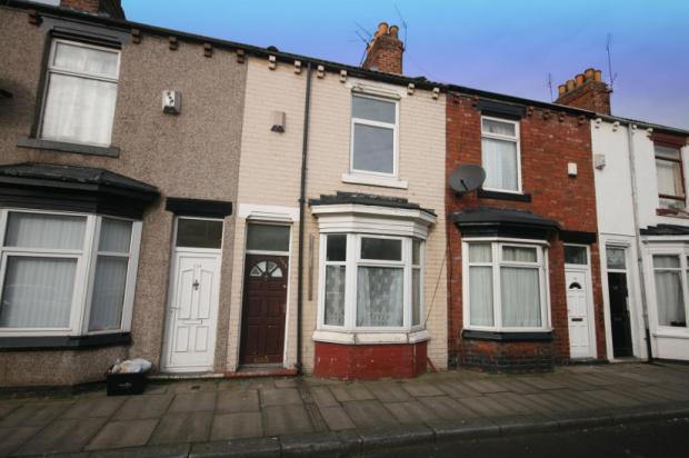
Photo 1
/ 1
Property details
Floor area
73 m²
Deprivation
Decile 1 (43 of 33,755)
Street crime
791 incidents within 1 mile (Apr 2026)
Additional details
- Garden
- Yes
Description
Bond: £530
DSS Welcome
Smokers Welcome
Students Welcome
No Pets
Children Welcome
Listed by
Middlesbrough
Michael Poole
Reference: 33187723
EPC Rating & Upgrade Cost
Fetching EPC data… Refresh this page in a moment.
Flood risk
Zone: 1
Risk: Low
Job (default Low)
Rental Range
Estimated market rent for Middlesbrough. Low = conservative, Realistic = average, Optimistic = best case.
Based on Local Authority from postcode lookup → Middlesbrough.
LHA (30th percentile) floor for Teesside: £474/mo (Apr 2025 – Mar 2026)
Location
Nearby
Nearest stations, universities and amenities (distance from property).
| Type | Name | Distance |
|---|---|---|
| Shop | Budgens | 0.1 miles |
| Shop | Crescent Road Post Office | 0.1 miles |
| Bus stop | Parkside Gardens | 0.2 miles |
| University | Teesside University | 0.6 miles |
| Hospital | Carter Bequest Hospital, Middlesbrough | 0.8 miles |
| Train station | Middlesbrough | 1.0 miles |
| Hospital | Tees Valley Hospital | 1.4 miles |
| Train station | James Cook | 1.9 miles |
| University | Durham University, Queen's Campus | 2.0 miles |
Street-level crime
| Category | Count |
|---|---|
| Violence and sexual offences | 257 |
| Anti-social behaviour | 130 |
| Shoplifting | 97 |
| Public order | 68 |
| Criminal damage and arson | 56 |
| Other theft | 40 |
| Burglary | 34 |
| Vehicle crime | 32 |
| Drugs | 25 |
| Robbery | 17 |
| Other crime | 16 |
| Possession of weapons | 7 |
| Bicycle theft | 6 |
| Theft from the person | 6 |
| Total incidents | 791 |
Within 1 mile during Apr 2026. Source: data.police.uk (England & Wales).
Schools nearby
Nearest open schools with Ofsted ratings (England). Closed schools are not shown. Data from Get Information about Schools and Ofsted.
| Name | Type | Distance | Ofsted |
|---|---|---|---|
| Sacred Heart Primary School | Primary | 0.1 miles | Good — 9 Jun 2024 |
| Ayresome Primary School | Primary | 0.2 miles | Good — 9 Jul 2023 |
| Archibald Primary School | Primary | 0.4 miles | Good — 6 Oct 2011 |
| Newport Primary School | Primary | 0.4 miles | Good — 18 May 2023 |
| Linthorpe Community Primary School | Primary | 0.5 miles | Outstanding — 29 Apr 2024 |
Rental Comparables
Loading rental comparables for this postcode. Refresh in a few minutes.