93A
MANOR PARK ROAD, LONDON, LONDON, GREATER LONDON NW10 4JU
£220,000
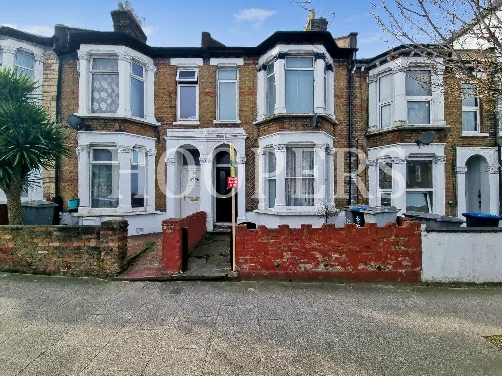
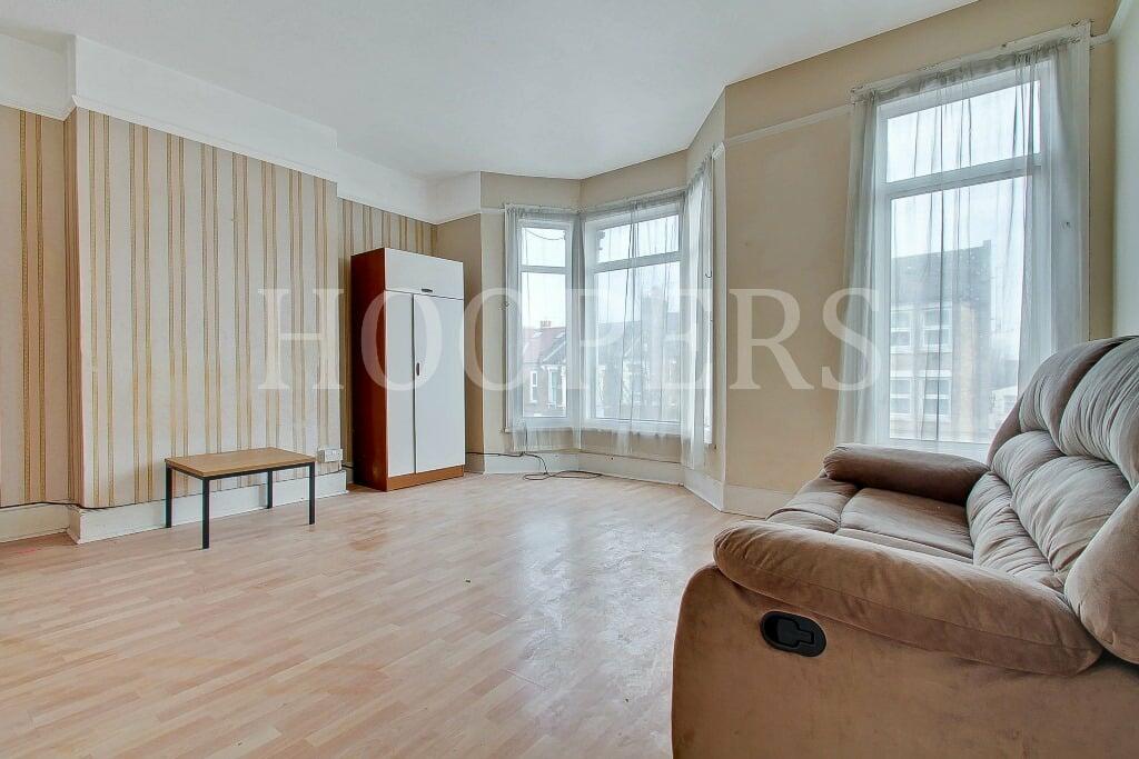
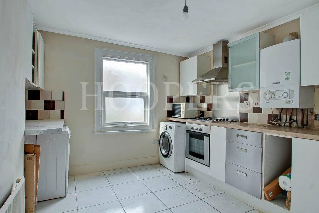
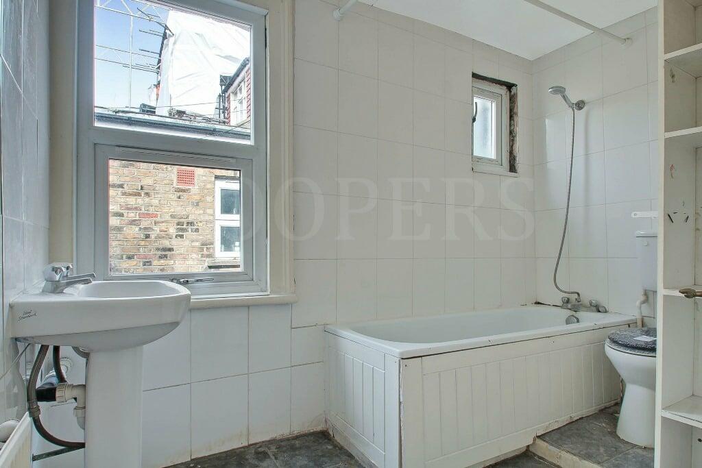
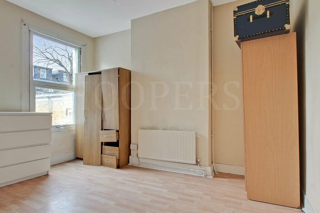
Photo 1 Photo 2 Photo 3 Photo 4 Photo 5
/ 5
Property details
Tenure
LEASEHOLD
Floor area
62 m²
Council tax band
C
EPC rating
D
Year built
England and Wales: before 1900
Last sold
£165,000 Mar 2004
Price per m²
£3,548/m²
Local average
£400,782 (-45.1%)
Deprivation
Decile 1 (799 of 33,755)
Street crime
824 incidents within 1 mile (Apr 2026)
Key features
- • CASH BUYERS ONLY
- • Gas central heating
- • Double glazed windows
- • Spacious lounge
- • Chain free sale
- • Local shopping facilities at Neasden are within a few hundred yards
- • Gross internal floor area (excluding loft space) of 656 sq ft (61 sq m) approximately
Additional details
- Listed property
- No
- Restrictions
- No
- Required access
- No
- Rights of way
- No
- Flooded in last 5 years
- No
- Flood defences
- No
Description
The property will be SOLD AS SEEN. All services/appliances have not and will not be tested.
The nearest stations are Harlesden or Willesden Junction (Bakerloo and overground services).
Listed by
Neasden
Hoopers
Reference: 145266461
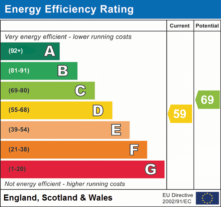
EPC Rating & Upgrade Cost
Current rating: D
Potential rating: C
Inspection date: 18/01/2024
Expiry date: 17/01/2034
Current heating cost: £1,051/year
Potential heating cost: £730/year
Est. upgrade cost to C: £10,175
Recommendations
- Flat roof or sloping ceiling insulation (£850 - £1,500)
- 50 mm internal or external wall insulation (£4,000 - £14,000)
Flood risk
Zone: 1
Risk: Low
Job (default Low)
Floorplans
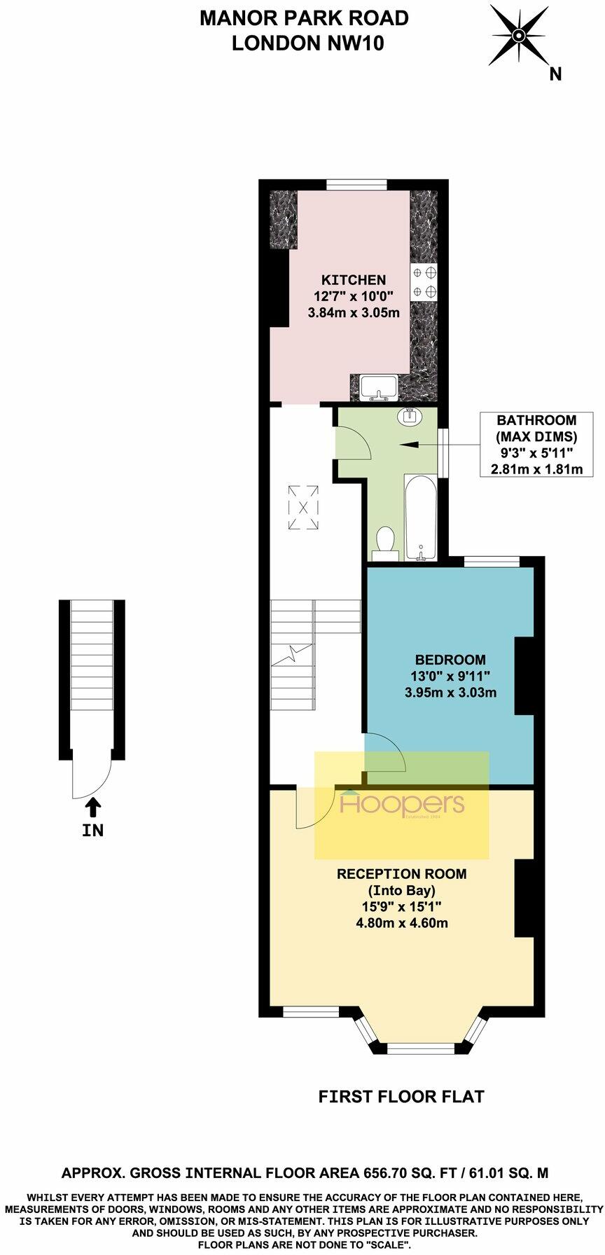
Floorplan 1
EPC Graphs
EPC 1
Price history
166% since 1998
| Event | Date | Price | % change |
|---|---|---|---|
| Sold | 12/03/2004 (22 years ago) | £165,000 | +68.4% |
| Sold | 17/01/2003 (23 years ago) | £98,000 | +58.1% |
| Sold | 30/04/1998 (28 years ago) | £62,000 | — |
Source: HM Land Registry Price Paid Data. Crown copyright.
Sold Comparables
Same street and nearby sales within 0.25 miles (last 5 years). Data from Land Registry Price Paid.
| Address | Price | Date | Type |
|---|---|---|---|
| 57 GROUND FLOOR FLAT MANOR PARK ROAD, LONDON, BRENT, GREATER LONDON, NW10 4JY | £280,000 | 19/12/2025 | Flat |
| Same street 93B MANOR PARK ROAD, LONDON, BRENT, GREATER LONDON, NW10 4JU | £285,000 | 18/08/2025 | Flat |
| 29B CHARLTON ROAD, LONDON, BRENT, GREATER LONDON, NW10 4BE | £150,000 | 25/02/2025 | Flat |
| 21A CHARLTON ROAD, LONDON, BRENT, GREATER LONDON, NW10 4BE | £247,000 | 15/01/2025 | Flat |
| 10 CHARLTON ROAD, LONDON, BRENT, GREATER LONDON, NW10 4BD | £255,000 | 10/12/2024 | Flat |
| 8A CHARLTON ROAD, LONDON, BRENT, GREATER LONDON, NW10 4BD | £260,000 | 05/12/2023 | Flat |
| 160 - 162 FLAT A MANOR PARK ROAD, LONDON, BRENT, GREATER LONDON, NW10 4JT | £180,000 | 28/11/2023 | Flat |
| 160 - 162 FLAT B MANOR PARK ROAD, LONDON, BRENT, GREATER LONDON, NW10 4JT | £275,000 | 28/11/2023 | Flat |
| 160 - 162 FLAT C MANOR PARK ROAD, LONDON, BRENT, GREATER LONDON, NW10 4JT | £280,000 | 28/11/2023 | Flat |
| ELLERY COURT FLAT 8 JUBILEE CLOSE, LONDON, BRENT, GREATER LONDON, NW10 9DZ | £375,000 | 28/09/2023 | Flat |
| 3 FLAT 2 NICOLL ROAD, LONDON, BRENT, GREATER LONDON, NW10 9AX | £350,000 | 29/03/2023 | Flat |
| Same street 89B MANOR PARK ROAD, LONDON, BRENT, GREATER LONDON, NW10 4JU | £343,000 | 13/01/2023 | Flat |
| 6A ST JOHNS AVENUE, LONDON, BRENT, GREATER LONDON, NW10 4EE | £385,000 | 01/12/2022 | Flat |
| 36 ST JOHNS AVENUE, LONDON, BRENT, GREATER LONDON, NW10 4EE | £360,000 | 01/11/2022 | Flat |
| 16 NICOLL ROAD, LONDON, BRENT, GREATER LONDON, NW10 9AB | £350,000 | 14/10/2022 | Flat |
| 12A CHARLTON ROAD, LONDON, BRENT, GREATER LONDON, NW10 4BD | £325,000 | 06/10/2022 | Flat |
| Same street GWALIA WORKING MENS CLUB MANOR PARK ROAD, LONDON, BRENT, GREATER LONDON, NW10 4JU | £2,070,000 | 26/08/2022 | Other |
| 45 FIRST FLOOR FLAT BURNS ROAD, LONDON, BRENT, GREATER LONDON, NW10 4DT | £380,000 | 08/04/2022 | Flat |
| 29A BURNS ROAD, LONDON, BRENT, GREATER LONDON, NW10 4DT | £325,000 | 27/08/2021 | Flat |
| 10 ST JOHNS AVENUE, LONDON, BRENT, GREATER LONDON, NW10 4EE | £354,000 | 29/07/2021 | Flat |
| 28A NICOLL ROAD, LONDON, BRENT, GREATER LONDON, NW10 9AB | £325,000 | 14/07/2021 | Flat |
Street average: £899,333 (3 sales)
Area average: £303,111 (18 sales)
Capital growth trend
Land Registry outcode average: last 12 months vs 5y and 10y ago (from sold prices).
House Price Index (HM Land Registry — official index, not sold-price averages): Brent. Series: Flats and maisonettes. As of March 2026.
Rental Range
Estimated market rent for Brent. Low = conservative, Realistic = average, Optimistic = best case.
Based on Local Authority from postcode lookup → Brent.
Location
Nearby
Nearest stations, universities and amenities (distance from property).
| Type | Name | Distance |
|---|---|---|
| Shop | Housewife Cash & Carry | 0.0 miles |
| Shop | Unknown | 0.0 miles |
| Bus stop | St Mary's Road | 0.1 miles |
| Bus stop | Tavistock Road | 0.1 miles |
| Train station | Harlesden | 0.4 miles |
| Train station | Willesden Junction | 0.5 miles |
| University | Scale Space White City | 2.0 miles |
| University | Kennet West Skills Centre | 2.2 miles |
| Hospital | The Portland Hospital | 4.6 miles |
| Hospital | Sleep & Health Clinic | 4.8 miles |
Street-level crime
| Category | Count |
|---|---|
| Anti-social behaviour | 223 |
| Violence and sexual offences | 213 |
| Vehicle crime | 82 |
| Criminal damage and arson | 47 |
| Other theft | 44 |
| Drugs | 41 |
| Burglary | 38 |
| Public order | 35 |
| Robbery | 26 |
| Shoplifting | 18 |
| Theft from the person | 18 |
| Possession of weapons | 17 |
| Bicycle theft | 11 |
| Other crime | 11 |
| Total incidents | 824 |
Within 1 mile during Apr 2026. Source: data.police.uk (England & Wales).
Schools nearby
Nearest open schools with Ofsted ratings (England). Closed schools are not shown. Data from Get Information about Schools and Ofsted.
| Name | Type | Distance | Ofsted |
|---|---|---|---|
| John Keble CofE Primary School | Primary | 0.1 miles | Good — 26 Jul 2023 |
| Saint Claudine's Catholic School for Girls | Secondary | 0.1 miles | Good — 3 Oct 2013 |
| Maple Walk School | Other | 0.1 miles | — (No rating) |
| Harlesden Primary School | Primary | 0.3 miles | Good — 20 Jul 2022 |
| Newfield Primary School | Primary | 0.3 miles | Good — 4 Jul 2019 |
Rental Comparables
Residential lets from OpenRent and Rightmove for the area (same bedroom count). Use to validate rent estimates. Student lets are excluded.
| Title | Rent | Beds | Distance | As seen on |
|---|---|---|---|---|
| Studio Flat, High Street, NW10 | £1,340/mo | 1 | 0.08 miles | OpenRent |
| Studio Flat, Connaught Rd, NW10 | £800/mo | 1 | 0.17 miles | OpenRent |
| Studio Flat, Park Parade, NW10 | £1,000/mo | 1 | 0.23 miles | OpenRent |
| Studio Flat, Buckingham Road, NW10 | £1,230/mo | 1 | 0.23 miles | OpenRent |
| 1 Bed Flat, Fortune Gate Road, NW10 | £1,695/mo | 1 | 0.31 miles | OpenRent |
| Studio Flat, Station Road, NW10 | £950/mo | 1 | 0.35 miles | OpenRent |
| Studio Flat, Craven Park, NW10 | £1,250/mo | 1 | 0.35 miles | OpenRent |
Average rent: £1,181/mo (7 listings)
Rent-driven metrics
Based on OpenRent comparables.
- Rent ratio — Monthly rent ÷ purchase price (1% rule). 1%+ = strong, 0.8–1% = okay, <0.8% = weak for cashflow.
- Max investor price — Rent ÷ 0.8%; the price at which rent would be 0.8% of price (Stoke-style target).
- Target investor price — Rent ÷ 1%; the price at which rent would be 1% of price (strong cashflow band).
- Gross yield — Annual rent as % of purchase price (no costs).
- Cost-to-rent — Price ÷ annual rent (from OpenRent comparables). Under 14× = strong, 14–16× = acceptable, 17×+ = compressed.
- Cashflow — Rent minus mortgage, 10% maintenance, £25/mo compliance. Assumes 75% LTV, 3.95% APR (5yr fixed), 25yr term.
- ROI — Annual profit ÷ cash in (deposit + 4% purchase costs).