3 MAGPIE AVENUE
BEDFORD, STEWARTBY, BEDFORDSHIRE MK43 9NP
£400 pcm
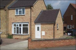
Photo 1
/ 1
Property details
Floor area
180 m²
EPC rating
E
Year built
England and Wales: 1950-1966
Deprivation
Decile 5 (15,216 of 33,755)
Street crime
8 incidents within 1 mile (Apr 2026)
Description
Listed by
Bedford
Leaders and Romans Group
Reference: 5891070
EPC Rating & Upgrade Cost
Current rating: E
Potential rating: D
Inspection date: 02/03/2020
Expiry date: 01/03/2030
Current heating cost: £1,426/year
Potential heating cost: £1,336/year
Est. upgrade cost to C: £6,000
Recommendations
- Floor insulation (suspended floor) (£800 - £1,200)
- Solar water heating (£4,000 - £6,000)
Flood risk
Zone: 1
Risk: Low
Job (default Low)
FENSA Certificates
This property has 1 FENSA certificate(s) on record, indicating window/door installations by FENSA-approved installers.
FENSA Certificate #15130742 Recent
Property Details
Street: 3 Magpie Avenue
Town: Stewartby
Postcode: MK43 9NP
Installation Details
Items: 2 doors
Certificate Issued: 03/04/2022
Work Completed: 28/02/2022
This certificate data was retrieved from FENSA's database
What is FENSA? FENSA (Fenestration Self-Assessment Scheme) is a government-authorised scheme that monitors building regulation compliance for replacement windows and doors. Certificates indicate that work was completed by FENSA-approved installers.
Rental Range
Estimated market rent for Bedford. Low = conservative, Realistic = average, Optimistic = best case.
Based on Local Authority from postcode lookup → Bedford.
LHA (30th percentile) floor for Bedford: £648/mo (Apr 2025 – Mar 2026)
Location
Nearby
Nearest stations, universities and amenities (distance from property).
| Type | Name | Distance |
|---|---|---|
| Shop | Unknown | 0.3 miles |
| Train station | Stewartby | 0.6 miles |
| Bus stop | Stewartby Turn | 0.6 miles |
| Bus stop | How End Bus Stop | 1.0 miles |
| Train station | Kempston Hardwick | 1.5 miles |
| Hospital | Steppingley Hospital | 4.1 miles |
| Hospital | Bedford Hospital SDEC - Same Day Emergency Care | 4.2 miles |
| University | Cranfield University | 5.1 miles |
| University | University of Bedfordshire Polhill Campus | 5.7 miles |
Street-level crime
| Category | Count |
|---|---|
| Shoplifting | 3 |
| Anti-social behaviour | 2 |
| Violence and sexual offences | 2 |
| Criminal damage and arson | 1 |
| Total incidents | 8 |
Within 1 mile during Apr 2026. Source: data.police.uk (England & Wales).
Schools nearby
Nearest open schools with Ofsted ratings (England). Closed schools are not shown. Data from Get Information about Schools and Ofsted.
| Name | Type | Distance | Ofsted |
|---|---|---|---|
| Broadmead Lower School | Primary | 0.2 miles | Good — 17 Sep 2023 |
| Marston Vale Middle School | Primary | 0.2 miles | — (Inspected (no overall grade)) |
| Kimberley 16 - 19 Stem College | Other | 0.8 miles | — (No rating) |
| Houghton Conquest Lower School | Primary | 1.5 miles | Good — 1 Jul 2024 |
| Marston Moreteyne VC School | Primary | 1.9 miles | Good — 6 May 2024 |
Rental Comparables
Loading rental comparables for this postcode. Refresh in a few minutes.