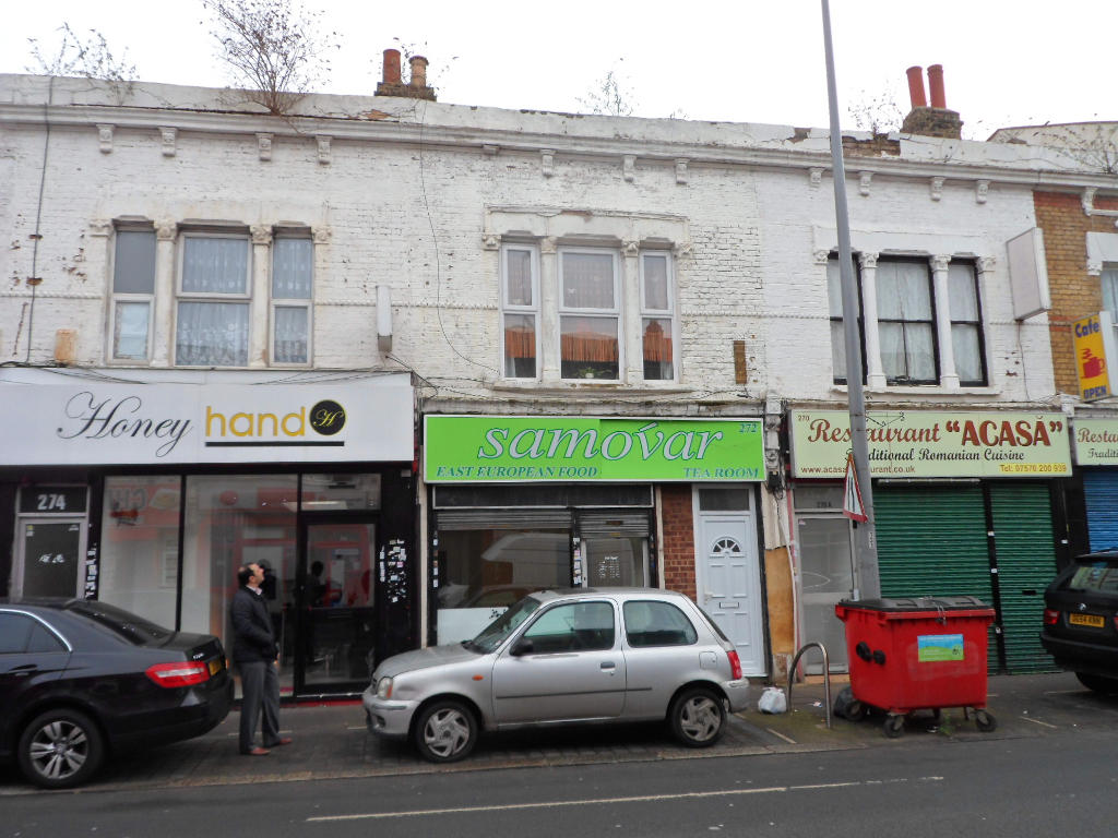
272 HIGH ROAD LEYTONSTONE
LONDON, LONDON, GREATER LONDON E11 3HS
£917 pcm
Property details
Last sold
£250,000 Feb 2007
Local average
£1,880,100 (-100%)
Deprivation
Decile 4 (10,531 of 33,755)
Street crime
1141 incidents within 1 mile (Apr 2026)
Key features
- Popular local parade and available on a "low" rent
- Fronts busy main road - parking available on local roads
- Is approx equal distance between Maryland Point and Leytonstone High Road Stations
- Suitable for variety of uses subject to planning consent
Additional details
- Parking
- Yes
Description
Situated on the eastside of High Road Leytonstone and close to its junction with Ranelagh Road, in a busy retail and residential area. Nearby occupiers include independent retailers and take-away's along High Road Leytonstone which is a busy thoroughfare connecting to Stratford in the South and the Green Man/A12 junction in the north. Both Leytonstone High Road Network Rail Station and Maryland Station are approximately of equal distance and numerous bus routes serve the A106 High Road Leytonstone leading through Leytonstone Road into Stratford.
Description:
An extended lock up shop. The property has been refurbished and suitably located to suit a variety of businesses. The shop is of a regular shape and offers the following accommodation: - Main Retail: 264.79 sq ft/ 24.6m2 - Rear Office (1): 153.38 sq ft/ 14.25 m2 - Rear Office (2): 68.88 sq ft/ 6.4 m2 (includes plumbed in sink and access to WC) - Rear Office (3): 171.79 sq ft/ 15.96 m2 (includes tea point with access to WC)
Listed by
London
Dobbin & Sullivan
Reference: 50004292
Flood risk
Zone: 1
Risk: Low
Job (default Low)
Price history
| Event | Date | Price | % change |
|---|---|---|---|
| Sold | 28/02/2007 (19 years ago) | £250,000 | — |
Source: HM Land Registry Price Paid Data. Crown copyright.
Sold Comparables
Same street and nearby sales within 0.25 miles (last 5 years). Data from Land Registry Price Paid.
| Address | Price | Date | Type |
|---|---|---|---|
| Same street 328A - 328B HIGH ROAD LEYTONSTONE, LONDON, WALTHAM FOREST, GREATER LONDON, E11 3HS | £235,000 | 27/11/2025 | Other |
| Same street 306 HIGH ROAD LEYTONSTONE, LONDON, WALTHAM FOREST, GREATER LONDON, E11 3HS | £377,000 | 11/10/2024 | Flat |
| 174A HIGH ROAD LEYTONSTONE, LONDON, WALTHAM FOREST, GREATER LONDON, E11 3HU | £495,000 | 18/11/2022 | Other |
| ALFRED APARTMENTS, 33 19 UNION CLOSE, LONDON, WALTHAM FOREST, GREATER LONDON, E11 4GU | £3,712,362 | 24/01/2022 | Other |
| 190 - 192 GROUND FLOOR SHOP HIGH ROAD LEYTONSTONE, LONDON, WALTHAM FOREST, GREATER LONDON, E11 3HU | £400,000 | 14/01/2022 | Other |
| 200 UPPER MEZZANINE FLAT HIGH ROAD LEYTONSTONE, LONDON, WALTHAM FOREST, GREATER LONDON, E11 3HU | £315,840 | 06/09/2021 | Other |
| 200 FLAT 1 HIGH ROAD LEYTONSTONE, LONDON, WALTHAM FOREST, GREATER LONDON, E11 3HU | £178,000 | 06/08/2021 | Other |
| Same street 294 HIGH ROAD LEYTONSTONE, LONDON, WALTHAM FOREST, GREATER LONDON, E11 3HS | £327,500 | 16/07/2021 | Flat |
Street average: £313,167 (3 sales)
Area average: £1,020,240 (5 sales)
Capital growth trend
Land Registry outcode average: last 12 months vs 5y and 10y ago (from sold prices).
House Price Index (HM Land Registry — official index, not sold-price averages): Waltham Forest. Series: All dwelling types. As of March 2026.
Company ownership
Registered legal owner is a company.
Company: PHLEX INVESTMENTS LIMITED (4163571)
Rental Range
Estimated market rent for Waltham Forest. Low = conservative, Realistic = average, Optimistic = best case.
Based on Local Authority from postcode lookup → Waltham Forest.
LHA (30th percentile) floor for Outer East London: Apr 2025 – Mar 2026
Location
Nearby
Nearest stations, universities and amenities (distance from property).
| Type | Name | Distance |
|---|---|---|
| Shop | Gospodina Magazin Românesc | 0.0 miles |
| Bus stop | Ranelagh Road | 0.0 miles |
| Shop | Barber Shop | 0.1 miles |
| Bus stop | Harrow Green | 0.1 miles |
| Train station | Leyton | 0.5 miles |
| Train station | Leytonstone High Road | 0.5 miles |
| University | University of East London | 0.9 miles |
| University | Arden University Stratford Campus | 1.2 miles |
| Hospital | Rainbow Ward | 2.6 miles |
| Hospital | A&E Department | 2.6 miles |
Street-level crime
| Category | Count |
|---|---|
| Anti-social behaviour | 302 |
| Violence and sexual offences | 234 |
| Shoplifting | 121 |
| Other theft | 91 |
| Vehicle crime | 76 |
| Theft from the person | 59 |
| Public order | 58 |
| Burglary | 55 |
| Drugs | 46 |
| Criminal damage and arson | 45 |
| Robbery | 20 |
| Possession of weapons | 17 |
| Other crime | 9 |
| Bicycle theft | 8 |
| Total incidents | 1141 |
Within 1 mile during Apr 2026. Source: data.police.uk (England & Wales).
Schools nearby
Nearest open schools with Ofsted ratings (England). Closed schools are not shown. Data from Get Information about Schools and Ofsted.
| Name | Type | Distance | Ofsted |
|---|---|---|---|
| The Jenny Hammond Primary School | Primary | 0.1 miles | Good — 23 Apr 2012 |
| Downsell Primary School | Primary | 0.2 miles | Good — 29 Jan 2024 |
| Mayville Primary School | Primary | 0.3 miles | Good — 12 Jun 2024 |
| Acacia Nursery | Nursery | 0.4 miles | Outstanding — 24 Jul 2023 |
| Buxton School | Other | 0.4 miles | Good — 12 Dec 2017 |
Rental Comparables
Residential lets from OpenRent and Rightmove for the area. Bedroom counts vary — use the Beds column to compare like-for-like lets. Student lets are excluded.
| Title | Rent | Beds | Distance | As seen on |
|---|---|---|---|---|
| 3 Bed Flat, South Birkbeck Road, E11 | £2,250/mo | 3 | 0.14 miles | OpenRent |
| 1 Bed Flat, High Road Leytonstone, E11 | £1,650/mo | 1 | 0.17 miles | OpenRent |
| 3 Bed Terraced House, Cheneys Road, E11 | £3,930/mo | 3 | 0.18 miles | OpenRent |
| 1 Bed Flat, High Road Leytonstone, E11 | £1,500/mo | 1 | 0.19 miles | OpenRent |
| 1 Bed Flat, High Road Leytonstone, E11 | £1,500/mo | 1 | 0.19 miles | OpenRent |
| 2 Bed Flat, High Road Leytonstone, E11 | £1,800/mo | 2 | 0.2 miles | OpenRent |
| Studio Flat, High Road Leytonstone, E11 | £1,100/mo | 1 | 0.21 miles | OpenRent |
| 2 Bed Flat, Borthwick Road, E15 | £2,050/mo | 2 | 0.24 miles | OpenRent |
| 2 Bed Flat, Crownfield Road, E15 | £2,350/mo | 2 | 0.25 miles | OpenRent |
| 2 Bed Flat, Crownfield Road, E15 | £2,350/mo | 2 | 0.25 miles | OpenRent |
| 2 Bed Flat, Arundel Close, E15 | £2,250/mo | 2 | 0.29 miles | OpenRent |
| 4 Bed Semi-Detached House, Calderon Road, E11 | £2,500/mo | 4 | 0.35 miles | OpenRent |
Average rent: £2,103/mo (12 listings)
Rent-driven metrics
Based on OpenRent comparables.
- This street — Gross yield for this street only (Land Registry sales + rental comparables, same postcode + street).
- Rent ratio — Monthly rent ÷ purchase price (1% rule). 1%+ = strong, 0.8–1% = okay, <0.8% = weak for cashflow.
- Max investor price — Rent ÷ 0.8%; the price at which rent would be 0.8% of price (Stoke-style target).
- Target investor price — Rent ÷ 1%; the price at which rent would be 1% of price (strong cashflow band).
- Gross yield — Annual rent as % of purchase price (no costs).
- Cashflow — Rent minus mortgage, 10% maintenance, £25/mo compliance. Assumes 75% LTV, 3.95% APR (5yr fixed), 25yr term.
- ROI — Annual profit ÷ cash in (deposit + 4% purchase costs).