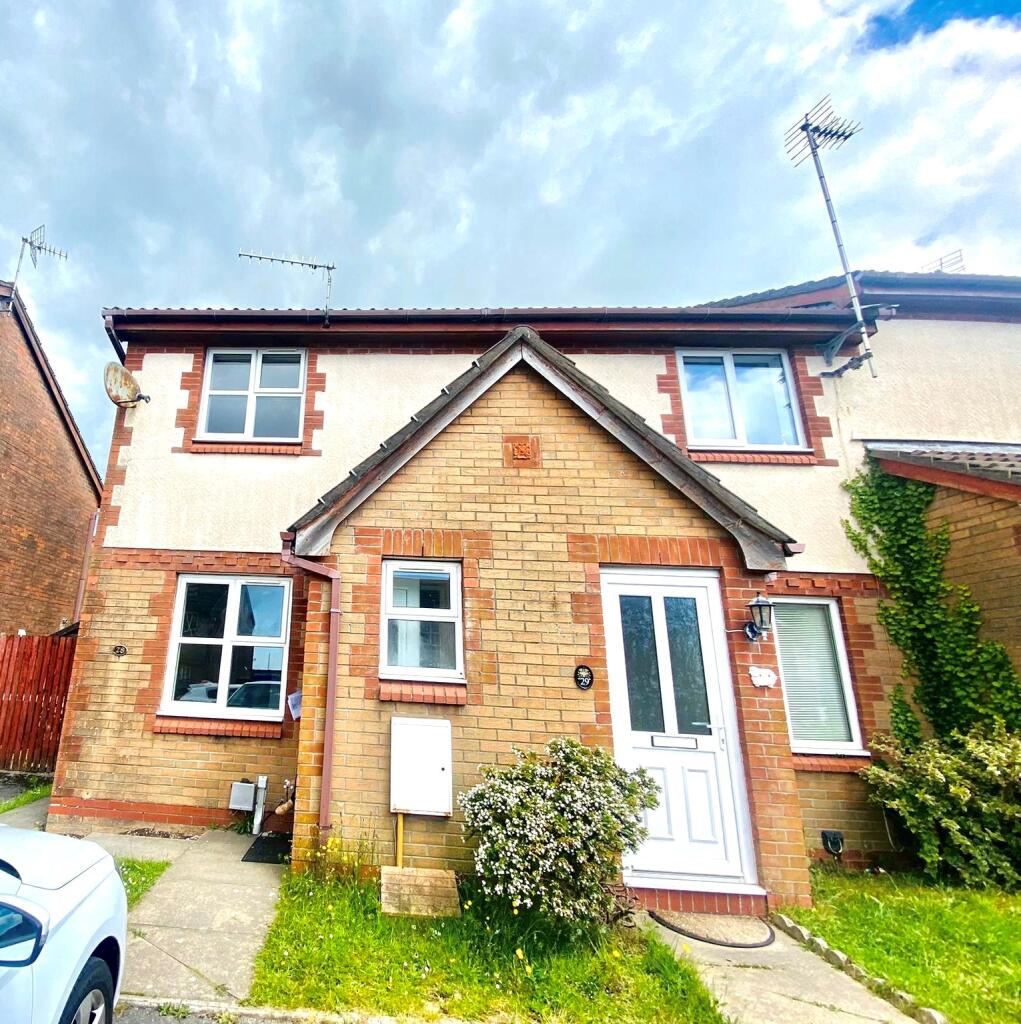
28 MAES LLAN
BRIDGEND, KENFIG HILL, BRIDGEND CF33 6DX
£875 pcm

Property details
Floor area
55 m²
Council tax band
B
Street crime
51 incidents within 1 mile (Apr 2026)
Key features
- 2 bedroom property
- Drive way parking
- Lovely location
Additional details
- Parking
- Yes
Description
COMING SOON
DESCRIPTION
COMING SOON
While every reasonable effort is made to ensure the accuracy of descriptions and content, we should make you aware of the following guidance or limitations.
(1) MONEY LAUNDERING REGULATIONS – prospective tenants will be asked to produce identification documentation during the referencing process and we would ask for your co-operation in order that there will be no delay in agreeing a tenancy.
(2) These particulars do not constitute part or all of an offer or contract.
(3) The text, photographs and plans are for guidance only and are not necessarily comprehensive.
(4) Measurements: These approximate room sizes are only intended as general guidance. You must verify the dimensions carefully to satisfy yourself of their accuracy.
(5) You should make your own enquiries regarding the property in respect of things such as furnishings to be included/excluded and what facilities are/are not available.
(6) Before you enter into any tenancy for one of the advertised properties, the condition and contents of the property will normally be set out in a tenancy agreement and inventory. Please make sure you carefully read and agree with the tenancy agreement and any inventory provided before signing these documents.
Listed by
Porthcawl
Peter Alan - Connells
Reference: 172720091
EPC Rating & Upgrade Cost
Fetching EPC data… Refresh this page in a moment.
Flood risk
Zone: 1
Risk: Low
Job (default Low)
EPC Graphs
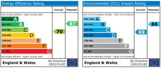
EPC
Rental Range
Estimated market rent for Bridgend. Low = conservative, Realistic = average, Optimistic = best case.
Based on Local Authority from postcode lookup → Bridgend.
Location
Nearby
Nearest stations, universities and amenities (distance from property).
| Type | Name | Distance |
|---|---|---|
| Shop | theFringe | 0.2 miles |
| Bus stop | Commercial Street (NE) | 0.3 miles |
| Shop | Spar | 0.3 miles |
| Bus stop | Unknown | 0.8 miles |
| Train station | Pyle | 1.0 miles |
| Hospital | Porthcawl Medical Centre | 3.1 miles |
| University | Union School of Theology | 3.4 miles |
| Train station | Tondu | 3.7 miles |
| University | Swansea University Bay Campus | 10.8 miles |
Street-level crime
| Category | Count |
|---|---|
| Violence and sexual offences | 26 |
| Criminal damage and arson | 9 |
| Anti-social behaviour | 7 |
| Public order | 4 |
| Other theft | 3 |
| Burglary | 1 |
| Drugs | 1 |
| Total incidents | 51 |
Within 1 mile during Apr 2026. Source: data.police.uk (England & Wales).
Schools nearby
Nearest open schools with Ofsted ratings (England). Closed schools are not shown. Data from Get Information about Schools and Ofsted.
| Name | Type | Distance | Ofsted |
|---|---|---|---|
| Cynffig Comprehensive School | Other | 0.2 miles | — (No rating) |
| Pil Primary School | Other | 0.7 miles | — (No rating) |
| Cefn Cribwr Primary School | Other | 1.2 miles | — (No rating) |
| Afon-Y-Felin Primary School | Other | 1.2 miles | — (No rating) |
| Ysgol Y Ferch O'r Sger | Other | 1.3 miles | — (No rating) |
Rental Comparables
Rental comparables are temporarily unavailable while listing-site fetches are paused. Try again later.