211A
LATCHMERE ROAD, LONDON, BATTERSEA, GREATER LONDON SW11 2LA
£2,275 pcm
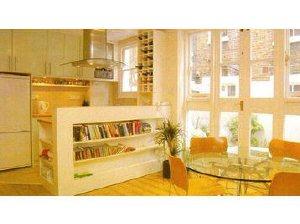
Photo 1
/ 1
Property details
Floor area
96 m²
Deprivation
Decile 7 (22,890 of 33,755)
Street crime
853 incidents within 1 mile (Apr 2026)
Key features
- Clapham
- Flat
- 3 Bedrooms
- 1 Receptions
- Furnished Property
Additional details
- Garden
- Yes
Description
Listed by
Balham
Belvoir
Reference: 18224673
EPC Rating & Upgrade Cost
Fetching EPC data… Refresh this page in a moment.
Flood risk
Zone: 1
Risk: Low
Job (default Low)
Company ownership
Registered legal owner is a company.
Company: 211 LATCHMERE ROAD LIMITED (9605866)
Rental Range
Estimated market rent for Wandsworth. Low = conservative, Realistic = average, Optimistic = best case.
Based on Local Authority from postcode lookup → Wandsworth.
LHA (30th percentile) floor for Stevenage & North Herts: £1,247/mo (Apr 2025 – Mar 2026)
Location
Nearby
Nearest stations, universities and amenities (distance from property).
| Type | Name | Distance |
|---|---|---|
| Shop | Costcutter | 0.0 miles |
| Shop | The Print Design | 0.0 miles |
| Bus stop | Battersea Arts Centre | 0.0 miles |
| Bus stop | Lavender Hill Police Station | 0.1 miles |
| Train station | Clapham Junction | 0.4 miles |
| Hospital | Bridge Lane Health Centre | 0.6 miles |
| Train station | Queenstown Road | 1.0 miles |
| University | National Heart and Lung Institute | 1.6 miles |
| University | BIMM Institute London | 1.8 miles |
| Hospital | King's College Hospital Emergency Department | 3.0 miles |
Street-level crime
| Category | Count |
|---|---|
| Anti-social behaviour | 228 |
| Violence and sexual offences | 170 |
| Vehicle crime | 91 |
| Other theft | 70 |
| Shoplifting | 65 |
| Burglary | 54 |
| Public order | 36 |
| Criminal damage and arson | 31 |
| Bicycle theft | 28 |
| Drugs | 24 |
| Robbery | 23 |
| Theft from the person | 19 |
| Other crime | 8 |
| Possession of weapons | 6 |
| Total incidents | 853 |
Within 1 mile during Apr 2026. Source: data.police.uk (England & Wales).
Schools nearby
Nearest open schools with Ofsted ratings (England). Closed schools are not shown. Data from Get Information about Schools and Ofsted.
| Name | Type | Distance | Ofsted |
|---|---|---|---|
| Shaftesbury Park Primary School | Primary | 0.3 miles | Good — 29 Nov 2013 |
| Sacred Heart Catholic Primary School, Battersea | Primary | 0.4 miles | Good — 26 Sep 2023 |
| Parkgate House School | Other | 0.4 miles | Outstanding — 28 Apr 2022 |
| Belleville Wix Academy | Primary | 0.5 miles | Good — 2 Dec 2019 |
| John Burns Primary School | Primary | 0.5 miles | Good — 6 Feb 2018 |
Rental Comparables
Residential lets from OpenRent and Rightmove for the area (same bedroom count). Use to validate rent estimates. Student lets are excluded.
| Title | Rent | Beds | Distance | As seen on |
|---|---|---|---|---|
| 3 Bed Maisonette, Sabine Road, SW11 | £3,500/mo | 3 | 0.24 miles | OpenRent |
| 3 Bed Flat, St. John's Road, SW11 | £2,500/mo | 3 | 0.36 miles | OpenRent |
| 3 Bed Terraced House, Dunston Road, SW11 | £3,500/mo | 3 | 0.48 miles | OpenRent |
Average rent: £3,167/mo (3 listings)