21 WRENBURY STREET
LIVERPOOL, LIVERPOOL, MERSEYSIDE L7 2PU
£56,212
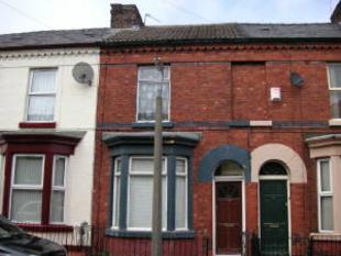
Photo 1
/ 1
Property details
Last sold
£74,950 Mar 2008
Local average
£145,904 (-61.5%)
Deprivation
Decile 1 (2,756 of 33,755)
Street crime
635 incidents within 1 mile (Apr 2026)
Key features
- Ownplace Scheme
- Eligible Buyers Receive
- Massive 25% Discount
- Terms & Conditions Apply
- Www.Ownplace.Org
Description
Listed by
Bromborough
Brennan Ayre O'Neill
Reference: 15979217
EPC Rating & Upgrade Cost
Fetching EPC data… Refresh this page in a moment.
Flood risk
Zone: 1
Risk: Low
Job (default Low)
FENSA Certificates
This property has 2 FENSA certificate(s) on record, indicating window/door installations by FENSA-approved installers.
FENSA Certificate #6232380
Property Details
Street: 21 Wrenbury Street
Town: LIVERPOOL
Postcode: L7 2PU
Installation Details
Items: 4 windows
Certificate Issued: 23/12/2008
Work Completed: 15/10/2008
This certificate data was retrieved from FENSA's database
FENSA Certificate #6310791
Property Details
Street: 21 Wrenbury Street
Town: LIVERPOOL
Postcode: L7 2PU
Installation Details
Items: 1 door
Certificate Issued: 02/02/2009
Work Completed: 20/11/2008
This certificate data was retrieved from FENSA's database
What is FENSA? FENSA (Fenestration Self-Assessment Scheme) is a government-authorised scheme that monitors building regulation compliance for replacement windows and doors. Certificates indicate that work was completed by FENSA-approved installers.
Price history
| Event | Date | Price | % change |
|---|---|---|---|
| Sold | 14/03/2008 (18 years ago) | £74,950 | — |
Source: HM Land Registry Price Paid Data. Crown copyright.
Sold Comparables
Same street and nearby sales within 0.25 miles (last 5 years). Data from Land Registry Price Paid.
| Address | Price | Date | Type |
|---|---|---|---|
| Same street 2 WRENBURY STREET, LIVERPOOL, MERSEYSIDE, L7 2PU | £162,000 | 19/12/2025 | Terraced |
| 93 CAMERON STREET, LIVERPOOL, MERSEYSIDE, L7 0EN | £120,000 | 19/12/2025 | Terraced |
| 39 NEEDHAM ROAD, LIVERPOOL, MERSEYSIDE, L7 0EE | £120,000 | 17/12/2025 | Terraced |
| 33 COTSWOLD STREET, LIVERPOOL, MERSEYSIDE, L7 2PY | £107,000 | 20/11/2025 | Terraced |
| 4 ODSEY STREET, LIVERPOOL, MERSEYSIDE, L7 0EB | £120,000 | 14/11/2025 | Terraced |
| 26 COTSWOLD STREET, LIVERPOOL, MERSEYSIDE, L7 2PZ | £125,000 | 10/09/2025 | Terraced |
| 61 NEEDHAM ROAD, LIVERPOOL, MERSEYSIDE, L7 0EF | £167,500 | 06/05/2025 | Terraced |
| 25 TOFT STREET, LIVERPOOL, MERSEYSIDE, L7 2PS | £90,000 | 19/03/2025 | Terraced |
| 84 HOLT ROAD, LIVERPOOL, MERSEYSIDE, L7 2PR | £225,000 | 17/02/2025 | Terraced |
| Same street 15 WRENBURY STREET, LIVERPOOL, MERSEYSIDE, L7 2PU | £103,000 | 23/02/2024 | Terraced |
| 130 FLAT 1 EDGE LANE, EDGE HILL, LIVERPOOL, MERSEYSIDE, L7 5NA | £200,000 | 13/11/2023 | Terraced |
| 113 NEEDHAM ROAD, LIVERPOOL, MERSEYSIDE, L7 0EF | £185,000 | 31/10/2023 | Terraced |
| 57 COTSWOLD STREET, LIVERPOOL, MERSEYSIDE, L7 2PY | £210,000 | 27/10/2023 | Terraced |
| 17 DIAL STREET, LIVERPOOL, MERSEYSIDE, L7 0EH | £320,000 | 27/10/2023 | Terraced |
| 19 ODSEY STREET, LIVERPOOL, MERSEYSIDE, L7 0EB | £125,000 | 10/10/2023 | Terraced |
| 39 FELL STREET, LIVERPOOL, MERSEYSIDE, L7 2QB | £38,130 | 25/09/2023 | Terraced |
| 4 FROST STREET, LIVERPOOL, MERSEYSIDE, L7 0EL | £72,000 | 19/09/2023 | Terraced |
| 72 FELL STREET, LIVERPOOL, MERSEYSIDE, L7 2QD | £126,000 | 25/08/2023 | Terraced |
| 24 COTSWOLD STREET, LIVERPOOL, MERSEYSIDE, L7 2PZ | £225,000 | 08/08/2023 | Terraced |
| Same street 13 WRENBURY STREET, LIVERPOOL, MERSEYSIDE, L7 2PU | £100,000 | 01/08/2023 | Terraced |
| 49 DEANE ROAD, LIVERPOOL, MERSEYSIDE, L7 0ES | £130,000 | 14/07/2023 | Terraced |
| 7 FROST STREET, LIVERPOOL, MERSEYSIDE, L7 0EL | £110,000 | 30/06/2023 | Terraced |
| 3 DIAL STREET, LIVERPOOL, MERSEYSIDE, L7 0EH | £210,000 | 14/06/2023 | Terraced |
| Same street 18 WRENBURY STREET, LIVERPOOL, MERSEYSIDE, L7 2PU | £203,650 | 26/11/2021 | Terraced |
| Same street 34 WRENBURY STREET, LIVERPOOL, MERSEYSIDE, L7 2PU | £265,000 | 24/06/2021 | Terraced |
Street average: £166,730 (5 sales)
Area average: £151,282 (20 sales)
Capital growth trend
Land Registry outcode average: last 12 months vs 5y and 10y ago (from sold prices).
House Price Index (HM Land Registry — official index, not sold-price averages): Liverpool. Series: Terraced. As of March 2026.
Rental Range
Estimated market rent for Liverpool. Low = conservative, Realistic = average, Optimistic = best case.
Based on Local Authority from postcode lookup → Liverpool.
LHA (30th percentile) floor for Greater Liverpool: £593/mo (Apr 2025 – Mar 2026)
Location
Nearby
Nearest stations, universities and amenities (distance from property).
| Type | Name | Distance |
|---|---|---|
| Shop | DKK Flowers ltd | 0.0 miles |
| Shop | Retro Hair Lounge | 0.0 miles |
| Bus stop | HOLT ROAD/EDGE LANE | 0.1 miles |
| Bus stop | Unknown | 0.1 miles |
| Train station | Edge Hill | 0.5 miles |
| Hospital | Paddington Community Diagnostic Centre | 0.5 miles |
| Hospital | Royal Liverpool University Hospital | 0.7 miles |
| University | University of Liverpool | 0.8 miles |
| Train station | Wavertree Technology Park | 1.0 miles |
Street-level crime
| Category | Count |
|---|---|
| Violence and sexual offences | 279 |
| Public order | 66 |
| Drugs | 57 |
| Other theft | 46 |
| Criminal damage and arson | 44 |
| Shoplifting | 34 |
| Anti-social behaviour | 29 |
| Burglary | 20 |
| Other crime | 15 |
| Possession of weapons | 14 |
| Vehicle crime | 13 |
| Robbery | 10 |
| Bicycle theft | 5 |
| Theft from the person | 3 |
| Total incidents | 635 |
Within 1 mile during Apr 2026. Source: data.police.uk (England & Wales).
Schools nearby
Nearest open schools with Ofsted ratings (England). Closed schools are not shown. Data from Get Information about Schools and Ofsted.
| Name | Type | Distance | Ofsted |
|---|---|---|---|
| Kensington Primary School | Primary | 0.1 miles | Good — 13 May 2024 |
| Marydale Lodge Sch | Other | 0.2 miles | — (No rating) |
| Harmonize Academy AP Free School | Other | 0.3 miles | Outstanding — 27 Apr 2015 |
| St Sebastian's Catholic Primary School and Nursery | Primary | 0.4 miles | — (Inspected (no overall grade)) |
| New Park Primary School | Primary | 0.5 miles | Outstanding — 27 Jan 2015 |
Rental Comparables
Rental listings exist nearby, but none matched the 2-bedroom count for this property.
Rent-driven metrics
Based on Area rent estimate.
- Rent ratio — Monthly rent ÷ purchase price (1% rule). 1%+ = strong, 0.8–1% = okay, <0.8% = weak for cashflow.
- Max investor price — Rent ÷ 0.8%; the price at which rent would be 0.8% of price (Stoke-style target).
- Target investor price — Rent ÷ 1%; the price at which rent would be 1% of price (strong cashflow band).
- Gross yield — Annual rent as % of purchase price (no costs).