Flat A
10, ABERDEEN ROAD, LONDON, GREATER LONDON N5 2UH
£2,383 pcm

Property details
Floor area
73 m²
Year built
England and Wales: before 1900
Deprivation
Decile 5 (15,558 of 33,755)
Street crime
1614 incidents within 1 mile (Apr 2026)
Key features
- Newly Refurbished
- Two Bedroom Apartment
- Private Garden
- Great Location
Additional details
- Garden
- Yes
Description
Quick Viewing Highly Recommended
Listed by
Islington
Campions - Chestertons
Reference: 114717395
EPC ratings on this postcode
We don't have a matched EPC for this property yet. Below are efficiency scores and details for other addresses on this postcode.
| Address | Current | Potential | Floor area | Age band | Type |
|---|---|---|---|---|---|
| 10a, Aberdeen Road, LONDON | 66 | 78 | 58 m² | England and Wales: before 1900 | Flat |
| 18A Aberdeen Road, LONDON | 69 | 80 | 91 m² | England and Wales: 1900-1929 | Flat |
| 20c Aberdeen Road, LONDON | 56 | 76 | 71 m² | England and Wales: 1900-1929 | Flat |
| 24b Aberdeen Road, LONDON | 74 | 80 | 45 m² | England and Wales: 1900-1929 | Flat |
| 26a Aberdeen Road, LONDON | 70 | 80 | 79 m² | England and Wales: before 1900 | Flat |
| 2c Abeerdeen Road, LONDON | 73 | 79 | 72 m² | England and Wales: before 1900 | Flat |
| 34, Aberdeen Road, LONDON | 53 | 68 | 47 m² | England and Wales: before 1900 | Flat |
| 34, Aberdeen Road, LONDON | 57 | 66 | 47 m² | England and Wales: before 1900 | Flat |
| 34, Aberdeen Road, LONDON | 51 | 68 | 47 m² | England and Wales: before 1900 | Flat |
| 34, Aberdeen Road, LONDON | 72 | 75 | 39 m² | England and Wales: before 1900 | Flat |
| 34, Aberdeen Road, LONDON | 73 | 80 | 53 m² | England and Wales: before 1900 | Flat |
| 4a, Aberdeen Road, LONDON | 63 | 76 | 80 m² | England and Wales: before 1900 | Flat |
| 4a, Aberdeen Road, LONDON | 60 | 79 | 103 m² | England and Wales: 1930-1949 | Flat |
| 4b Aberdeen Road, LONDON | 64 | 78 | 33 m² | England and Wales: 1900-1929 | Flat |
| 4c Aberdeen Road, LONDON | 56 | 79 | 42 m² | England and Wales: before 1900 | Flat |
Flood risk
Zone: 1
Risk: Low
Job (default Low)
EPC Graphs
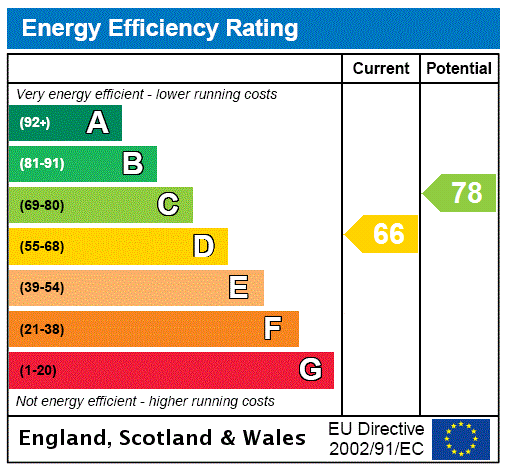
EPC Rating Graph
Rental Range
Estimated market rent for Islington. Low = conservative, Realistic = average, Optimistic = best case.
Based on Local Authority from postcode lookup → Islington.
LHA (30th percentile) floor for Cambridge: £947/mo (Apr 2025 – Mar 2026)
Location
Address
Aberdeen Road
Nearby
Nearest stations, universities and amenities (distance from property).
| Type | Name | Distance |
|---|---|---|
| Bus stop | Balfour Road / Lexfield House | 0.1 miles |
| Bus stop | Balfour Road / Athenaeum Court | 0.1 miles |
| Shop | Da Mario | 0.1 miles |
| Shop | La Fromagerie | 0.1 miles |
| Train station | Canonbury | 0.4 miles |
| Train station | Drayton Park | 0.5 miles |
| Hospital | Moorfields at Hoxton | 1.4 miles |
| University | University of Wales Trinity Saint David London | 1.4 miles |
| University | Paris Dauphine University - London Campus | 1.6 miles |
| Hospital | Medlabs Diagnostics | 2.4 miles |
Street-level crime
| Category | Count |
|---|---|
| Anti-social behaviour | 362 |
| Violence and sexual offences | 348 |
| Theft from the person | 184 |
| Public order | 115 |
| Shoplifting | 109 |
| Other theft | 104 |
| Drugs | 77 |
| Burglary | 75 |
| Criminal damage and arson | 64 |
| Robbery | 55 |
| Vehicle crime | 52 |
| Bicycle theft | 41 |
| Other crime | 20 |
| Possession of weapons | 8 |
| Total incidents | 1614 |
Within 1 mile during Apr 2026. Source: data.police.uk (England & Wales).
Schools nearby
Nearest open schools with Ofsted ratings (England). Closed schools are not shown. Data from Get Information about Schools and Ofsted.
| Name | Type | Distance | Ofsted |
|---|---|---|---|
| Highbury Quadrant Primary School | Primary | 0.1 miles | Requires improvement — 17 Sep 2023 |
| The London Screen Academy | Other | 0.2 miles | — (No rating) |
| St Joan of Arc RC Primary School | Primary | 0.2 miles | Good — 1 Sep 2014 |
| Highbury Fields School | Secondary | 0.3 miles | Outstanding — 10 Nov 2016 |
| City of London Academy Highbury Grove | Secondary | 0.3 miles | Good — 20 Jun 2022 |
Rental Comparables
Residential lets from OpenRent and Rightmove for the area (same bedroom count). Use to validate rent estimates. Student lets are excluded.
| Title | Rent | Beds | Distance | As seen on |
|---|---|---|---|---|
| 2 Bed Flat, Avenell Road, N5 | £3,240/mo | 2 | 0.48 miles | OpenRent |
Average rent: £3,240/mo (1 listing)
Enter House Number
Enter the house number to help us retrieve more accurate pricing history and property data.
Please log in to submit or correct the house number for this listing.
Log in to continue