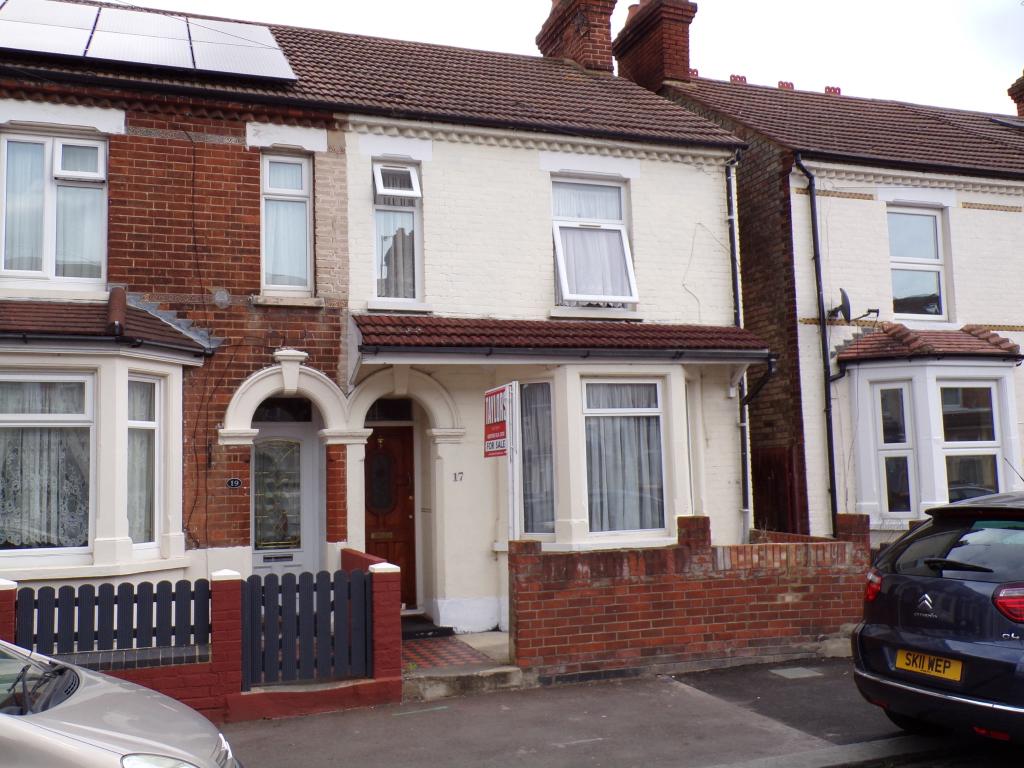
17 WHITBREAD AVENUE
BEDFORD, BEDFORD MK42 9DY
£220,000
Property details
Tenure
FREEHOLD
Floor area
88 m²
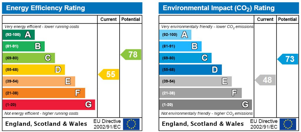
EPC rating
D
Year built
England and Wales: 1900-1929
Last sold
£220,000 Sep 2021
Price per m²
£2,500/m²
Local average
£284,039 (-22.5%)
Deprivation
Decile 3 (8,740 of 33,755)
Street crime
660 incidents within 1 mile (Apr 2026)
Key features
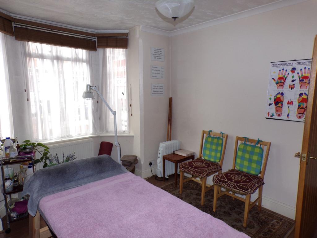
- Three bedrooms
- Bay fronted
- End of terrace
- Separate reception rooms
- Fitted kitchen
- Double glazing
- Radiator heating
- Ideal first time buy
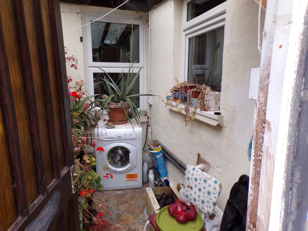
- Is in need of some updating and modernisation
- Walking distance to the river
Additional details
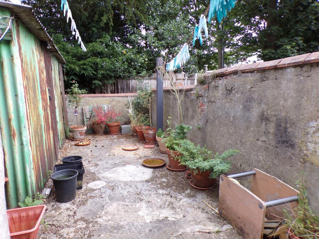
- Garden
- Yes
Description
Located on the south side of Bedford on Whitbread Avenue in between Kempston and Bedford.
Listed by
Bedford
Countrywide UK Sales - Connells
Reference: 63613620
EPC Rating & Upgrade Cost
Current rating: D
Potential rating: C
Inspection date: 28/06/2018
Expiry date: 27/06/2028
Current heating cost: £882/year
Potential heating cost: £630/year
Recommendations
- 50 mm internal or external wall insulation (14,000)
- Floor insulation (suspended floor) (1,200)
- Low energy lighting for all fixed outlets (35)
- Solar water heating (6,000)
- Solar photovoltaic panels, 2.5 kWp (8,000)
Flood risk
Zone: 1
Risk: Low
Job (default Low)
Floorplans
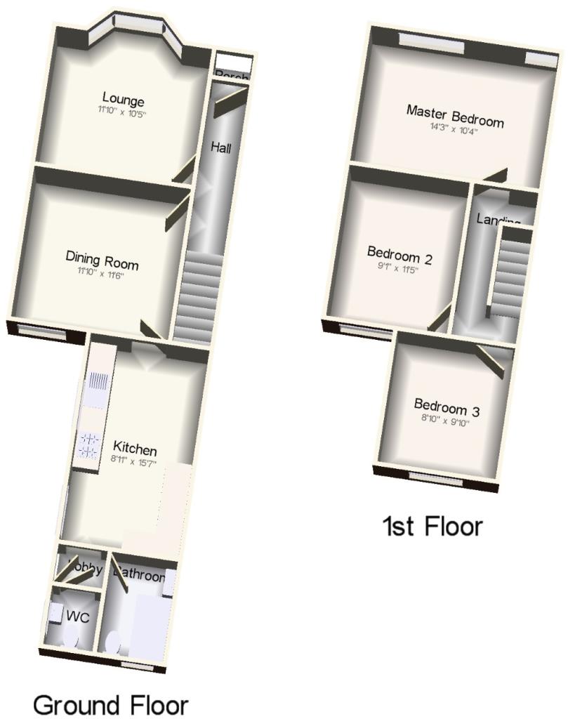
CWQuickSketch.jpg
EPC Graphs

EPC

Energy Certificate
Energy Certificate
Price history
| Event | Date | Price | % change |
|---|---|---|---|
| Sold | 03/09/2021 (4 years ago) | £220,000 | — |
Source: HM Land Registry Price Paid Data. Crown copyright.
Sold Comparables
Same street and nearby sales within 0.25 miles (last 5 years). Data from Land Registry Price Paid.
| Address | Price | Date | Type |
|---|---|---|---|
| 24 STAFFORD ROAD, BEDFORD, MK42 9EA | £290,000 | 17/07/2025 | Terraced |
| Same street 35 WHITBREAD AVENUE, BEDFORD, MK42 9DY | £200,000 | 28/02/2025 | Other |
| 51 EDWARD ROAD, BEDFORD, MK42 9DR | £239,000 | 20/12/2023 | Terraced |
| 14 PATTERN CLOSE, BEDFORD, MK42 9AY | £350,000 | 15/12/2023 | Terraced |
| 2 MARNE STREET, KEMPSTON, BEDFORD, MK42 8AG | £225,000 | 11/10/2023 | Terraced |
| Same street 16 WHITBREAD AVENUE, BEDFORD, MK42 9DY | £255,000 | 27/09/2023 | Terraced |
| 2 PATTERN CLOSE, BEDFORD, MK42 9AY | £330,000 | 21/09/2023 | Terraced |
| 4 STAFFORD ROAD, BEDFORD, MK42 9EA | £252,000 | 12/09/2023 | Terraced |
| 70 BEATRICE STREET, KEMPSTON, BEDFORD, MK42 8DF | £307,000 | 31/08/2023 | Terraced |
| 24 RYSWICK ROAD, KEMPSTON, BEDFORD, MK42 8SN | £230,000 | 04/08/2023 | Terraced |
| 8 EDWARD ROAD, BEDFORD, MK42 9DR | £187,500 | 16/06/2023 | Terraced |
| 4 GRANVILLE STREET, BEDFORD, MK42 9DZ | £240,000 | 04/05/2023 | Terraced |
| Same street 29 WHITBREAD AVENUE, BEDFORD, MK42 9DY | £230,000 | 28/04/2023 | Terraced |
| 7E KEMPSTON ROAD, BEDFORD, MK42 9AE | £340,000 | 17/03/2023 | Terraced |
| 11 PATTERN CLOSE, BEDFORD, MK42 9AY | £250,000 | 02/02/2023 | Terraced |
| 8 EDWARD ROAD, BEDFORD, MK42 9DR | £155,000 | 05/12/2022 | Terraced |
| 78 BEATRICE STREET, KEMPSTON, BEDFORD, MK42 8DF | £290,000 | 25/11/2022 | Terraced |
| 16 AUSTIN CANONS, KEMPSTON, BEDFORD, MK42 8AS | £328,075 | 16/11/2022 | Terraced |
| 8 KEMPSTON ROAD, BEDFORD, MK42 9DL | £350,000 | 21/10/2022 | Terraced |
| 14 AUSTIN CANONS WAY, KEMPSTON, BEDFORD, MK42 8DY | £350,000 | 15/09/2022 | Terraced |
| 42 BEATRICE STREET, KEMPSTON, BEDFORD, MK42 8AE | £300,000 | 02/09/2022 | Terraced |
| 10 CHAMPION WAY, BEDFORD, MK42 9AF | £351,000 | 25/08/2022 | Terraced |
| 18 MARLBOROUGH PARK, KEMPSTON, BEDFORD, MK42 8AN | £325,000 | 03/08/2022 | Terraced |
Street average: £228,333 (3 sales)
Area average: £284,479 (20 sales)
Capital growth trend
Land Registry outcode average: last 12 months vs 5y and 10y ago (from sold prices).
House Price Index (HM Land Registry — official index, not sold-price averages): Bedford. Series: Terraced. As of March 2026.
Rental Range
Estimated market rent for Bedford. Low = conservative, Realistic = average, Optimistic = best case.
Based on Local Authority from postcode lookup → Bedford.
LHA (30th percentile) floor for Bedford: £997/mo (Apr 2025 – Mar 2026)
Location
Nearby
Nearest stations, universities and amenities (distance from property).
| Type | Name | Distance |
|---|---|---|
| Shop | Lambert | 0.0 miles |
| Shop | Bangher Supermarket | 0.0 miles |
| Bus stop | Whitbread Avenue | 0.1 miles |
| Hospital | Bedford Hospital SDEC - Same Day Emergency Care | 0.4 miles |
| Train station | Bedford St Johns | 0.5 miles |
| Train station | Bedford | 0.6 miles |
| Hospital | The Manor | 1.6 miles |
| University | University of Bedfordshire Polhill Campus | 1.9 miles |
| University | University of Bedfordshire | 8.6 miles |
Street-level crime
| Category | Count |
|---|---|
| Violence and sexual offences | 233 |
| Anti-social behaviour | 101 |
| Shoplifting | 99 |
| Public order | 43 |
| Criminal damage and arson | 38 |
| Other theft | 31 |
| Vehicle crime | 29 |
| Drugs | 18 |
| Burglary | 13 |
| Robbery | 13 |
| Other crime | 12 |
| Bicycle theft | 11 |
| Possession of weapons | 11 |
| Theft from the person | 8 |
| Total incidents | 660 |
Within 1 mile during Apr 2026. Source: data.police.uk (England & Wales).
Schools nearby
Nearest open schools with Ofsted ratings (England). Closed schools are not shown. Data from Get Information about Schools and Ofsted.
| Name | Type | Distance | Ofsted |
|---|---|---|---|
| St John's School | Other | 0.1 miles | Good — 9 Nov 2023 |
| Cauldwell School | Primary | 0.3 miles | Good — 8 Jul 2013 |
| Peter Pan Nursery School | Nursery | 0.3 miles | Outstanding — 5 Mar 2013 |
| Bedford College | Other | 0.7 miles | — (No rating) |
| Bedford Free School | Secondary | 0.7 miles | Outstanding — 23 Mar 2020 |
Rental Comparables
Residential lets from OpenRent and Rightmove for the area (same bedroom count). Use to validate rent estimates. Student lets are excluded.
| Title | Rent | Beds | Distance | As seen on |
|---|---|---|---|---|
| 3 Bed Terraced House, The Sidings, MK42 | £650/mo | 3 | 0.68 miles | OpenRent |
| 3 Bed Semi-Detached House, Woburn Road, MK42 | £3,500/mo | 3 | 1.17 miles | OpenRent |
| 3 Bed Terraced House, Garfield St, MK41 | £1,595/mo | 3 | 1.23 miles | OpenRent |
Average rent: £1,915/mo (3 listings)
Rent-driven metrics
Based on OpenRent comparables.
- Rent ratio — Monthly rent ÷ purchase price (1% rule). 1%+ = strong, 0.8–1% = okay, <0.8% = weak for cashflow.
- Max investor price — Rent ÷ 0.8%; the price at which rent would be 0.8% of price (Stoke-style target).
- Target investor price — Rent ÷ 1%; the price at which rent would be 1% of price (strong cashflow band).
- Gross yield — Annual rent as % of purchase price (no costs).
- Cost-to-rent — Price ÷ annual rent (from OpenRent comparables). Under 14× = strong, 14–16× = acceptable, 17×+ = compressed.
- Cashflow — Rent minus mortgage, 10% maintenance, £25/mo compliance. Assumes 75% LTV, 3.95% APR (5yr fixed), 25yr term.
- ROI — Annual profit ÷ cash in (deposit + 4% purchase costs).