16 MANOR HALL AVENUE
LONDON, LONDON, GREATER LONDON NW4 1NX
£1,400,000
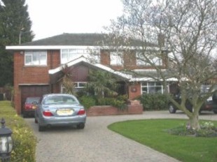
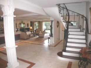


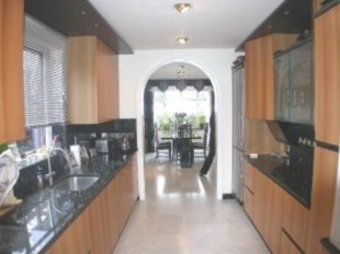

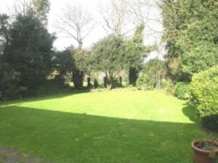
Photo 1 Photo 2 Photo 3 Photo 4 Photo 5 Photo 6 Photo 7
/ 7
Property details
Tenure
FREEHOLD
Last sold
£1,400,000 May 2007
Local average
£2,019,809 (-30.7%)
Deprivation
Decile 6 (17,271 of 33,755)
Street crime
311 incidents within 1 mile (Apr 2026)
Additional details
- Parking
- Yes
- Garden
- Yes
Description
ENT/HALL * OPEN PLAN LIVING/DINING AREA * STUDY * KITCHEN * BREAKFAST ROOM * GUEST CLOAKROOM * PRINCIPLE BEDROOM WITH EN-SUITE BATHROOM * 3 FURTHER BEDROOMS * BATHROOM * FRONT & BACK GARDENS * OSP * INTERNAL GARAGE. SOLE AGENT.
Dimensions
Bedroom 1:
Bedroom 2:
Bedroom 3:
Bedroom 4:
Reception 1:
Reception 2:
Reception 3:
Kitchen:
21 4 x 12
12 4 x 11 10
12 x 9 3
14 4 x 9 4
33 x 21
15 4 x 11 10
17 x 9 1
16 x 9 1
Listed by
Hendon
Dexters
Reference: 14590763
EPC Rating & Upgrade Cost
Fetching EPC data… Refresh this page in a moment.
Flood risk
Zone: 1
Risk: Low
Job (default Low)
FENSA Certificates
This property has 1 FENSA certificate(s) on record, indicating window/door installations by FENSA-approved installers.
FENSA Certificate #9144742
Property Details
Street: 16 Manor Hall Avenue
Town: LONDON
Postcode: NW4 1NX
Installation Details
Items: 1 window
Certificate Issued: 22/10/2012
Work Completed: 12/10/2012
This certificate data was retrieved from FENSA's database
What is FENSA? FENSA (Fenestration Self-Assessment Scheme) is a government-authorised scheme that monitors building regulation compliance for replacement windows and doors. Certificates indicate that work was completed by FENSA-approved installers.
Price history
268% since 1995
| Event | Date | Price | % change |
|---|---|---|---|
| Sold | 25/05/2007 (19 years ago) | £1,400,000 | +215.7% |
| Sold | 17/11/1995 (30 years ago) | £443,500 | +16.7% |
| Sold | 28/04/1995 (31 years ago) | £380,000 | — |
Source: HM Land Registry Price Paid Data. Crown copyright.
Sold Comparables
Same street and nearby sales within 0.25 miles (last 5 years). Data from Land Registry Price Paid.
| Address | Price | Date | Type |
|---|---|---|---|
| Same street 14 MANOR HALL AVENUE, LONDON, BARNET, GREATER LONDON, NW4 1NX | £1,640,000 | 04/07/2023 | Detached |
| Same street 26 MANOR HALL AVENUE, LONDON, BARNET, GREATER LONDON, NW4 1NX | £1,910,000 | 03/07/2023 | Semi-detached |
| CONIFER COURT, 205 FLAT 5 GREAT NORTH WAY, LONDON, BARNET, GREATER LONDON, NW4 1PN | £307,500 | 28/01/2023 | Other |
| 168 GREAT NORTH WAY, LONDON, BARNET, GREATER LONDON, NW4 1EN | £11,807,869 | 15/11/2021 | Other |
Street average: £1,775,000 (2 sales)
Area average: £6,057,685 (2 sales)
Capital growth trend
Land Registry outcode average: last 12 months vs 5y and 10y ago (from sold prices).
House Price Index (HM Land Registry — official index, not sold-price averages): Barnet. Series: All dwelling types. As of March 2026.
Rental Range
Estimated market rent for Barnet. Low = conservative, Realistic = average, Optimistic = best case.
Based on Local Authority from postcode lookup → Barnet.
LHA (30th percentile) floor for Outer North London: £2,194/mo (Apr 2025 – Mar 2026)
Location
Nearby
Nearest stations, universities and amenities (distance from property).
| Type | Name | Distance |
|---|---|---|
| Bus stop | Great North Way | 0.1 miles |
| Shop | Kwik Fit | 0.4 miles |
| Shop | Cake Create | 0.4 miles |
| Train station | Mill Hill East | 0.8 miles |
| University | Flood Hazard Research Centre | 1.0 miles |
| University | Middlesex University | 1.1 miles |
| Train station | Hendon Central | 1.1 miles |
| Hospital | Priory Hospital | 4.9 miles |
| Hospital | North London Hospice Winchmore Hill | 5.7 miles |
Street-level crime
| Category | Count |
|---|---|
| Violence and sexual offences | 86 |
| Anti-social behaviour | 71 |
| Vehicle crime | 41 |
| Other theft | 26 |
| Public order | 19 |
| Shoplifting | 15 |
| Criminal damage and arson | 14 |
| Burglary | 12 |
| Drugs | 8 |
| Other crime | 7 |
| Theft from the person | 5 |
| Bicycle theft | 3 |
| Robbery | 3 |
| Possession of weapons | 1 |
| Total incidents | 311 |
Within 1 mile during Apr 2026. Source: data.police.uk (England & Wales).
Schools nearby
Nearest open schools with Ofsted ratings (England). Closed schools are not shown. Data from Get Information about Schools and Ofsted.
| Name | Type | Distance | Ofsted |
|---|---|---|---|
| Hasmonean High School for Boys | Secondary | 0.1 miles | Good — 14 Dec 2023 |
| Kisharon School | Other | 0.3 miles | Good — 19 Mar 2023 |
| Kisharon College | Other | 0.4 miles | — (No rating) |
| Hendon Preparatory School | Other | 0.5 miles | — (No rating) |
| Nancy Reuben Primary School | Other | 0.6 miles | — (No rating) |
Rental Comparables
Residential lets from OpenRent and Rightmove for the area (same bedroom count). Use to validate rent estimates. Student lets are excluded.
| Title | Rent | Beds | Distance | As seen on |
|---|---|---|---|---|
| 4 Bed Flat, Church Road, NW4 | £3,100/mo | 4 | 0.58 miles | OpenRent |
Average rent: £3,100/mo (1 listing)
Rent-driven metrics
Based on OpenRent comparables.
- Rent ratio — Monthly rent ÷ purchase price (1% rule). 1%+ = strong, 0.8–1% = okay, <0.8% = weak for cashflow.
- Max investor price — Rent ÷ 0.8%; the price at which rent would be 0.8% of price (Stoke-style target).
- Target investor price — Rent ÷ 1%; the price at which rent would be 1% of price (strong cashflow band).
- Gross yield — Annual rent as % of purchase price (no costs).
- Cost-to-rent — Price ÷ annual rent (from OpenRent comparables). Under 14× = strong, 14–16× = acceptable, 17×+ = compressed.
- Cashflow — Rent minus mortgage, 10% maintenance, £25/mo compliance. Assumes 75% LTV, 3.95% APR (5yr fixed), 25yr term.
- ROI — Annual profit ÷ cash in (deposit + 4% purchase costs).