Oak Farm
Broxton - Lot 4, CH3 9JS
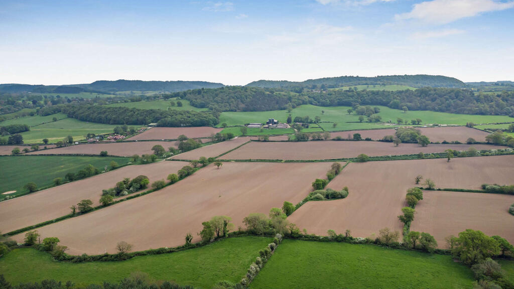
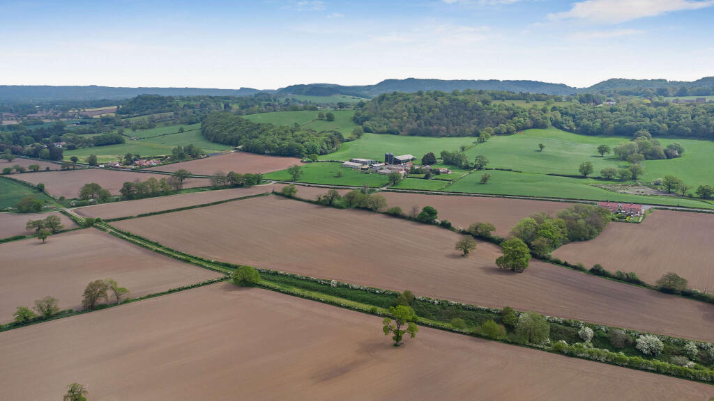
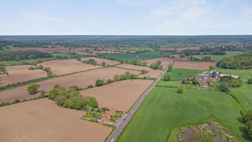
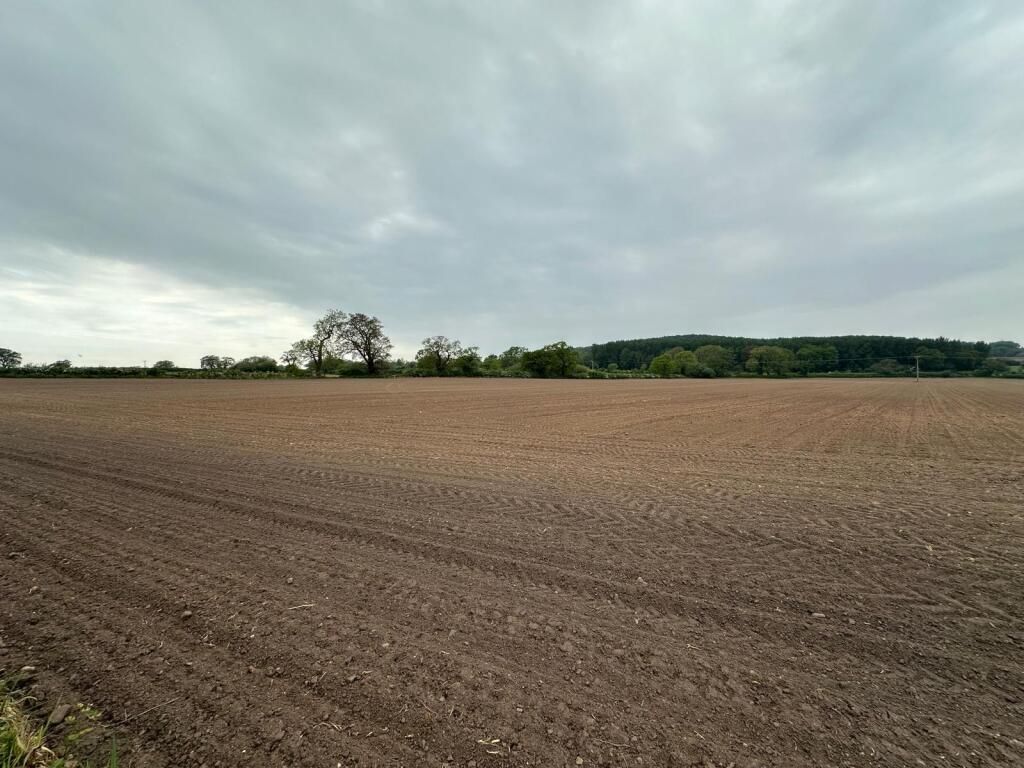
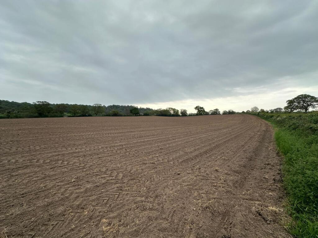
Photo 1 Photo 2 Photo 3 Photo 4 Photo 5
/ 5
Property details
Local average
£527,200 (+156.1%)
Deprivation
Decile 6 (18,516 of 33,755)
Street crime
0 incidents within 1 mile (Apr 2026)
Key features
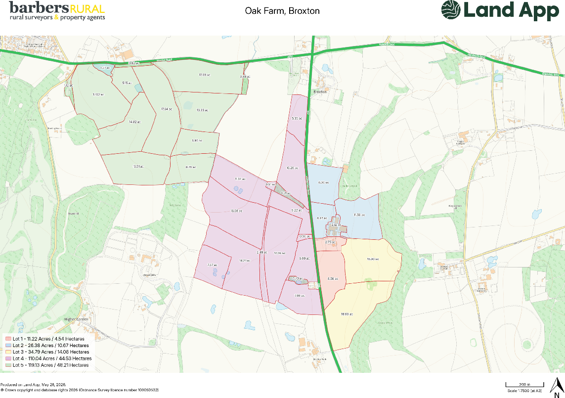
- Approximately 110.04 Acres (44.53 Ha) of agricultural land
- Productive Grade 3 land
- Accessible field parcels with frontage to the A41
- Internal access via farm track and former railway line
- Suitable for arable, livestock and general agricultural use
Description
The land is divided into a number of field parcels, several of which benefit from direct frontage to the A41, with the remainder accessed via a useful gravel farm track and former railway line that traverse the holding. The layout provides excellent accessibility for modern farming operations and ease of management.
The land is currently laid to maize and forms part of a productive agricultural unit. Classified as Grade 3 on the Soil Survey of England and Wales, the land comprises slowly permeable, slightly acid but base-rich loamy and clayey soils capable of supporting a range of agricultural enterprises.
The parcel offers opportunities for continued arable production, livestock farming, environmental schemes or strategic land investment. Its scale, accessibility and location make it suitable for both owner-occupiers and investors seeking a substantial block of productive farmland in a well-regarded farming area.
Lot Four is available as part of Oak Farm, which is offered for sale as a whole or in up to five lots.
Listed by
Market Drayton
Barbers Rural Consultancy LLP
Reference: 89711970
EPC ratings on this postcode
We don't have a matched EPC for this property yet. Below are efficiency scores and details for other addresses on this postcode.
| Address | Current | Potential | Floor area | Age band | Type |
|---|---|---|---|---|---|
| 2 Broxton Hall Mews, Whitchurch Road, Broxton, CHESTER | 65 | 83 | 81 m² | England and Wales: 1976-1982 | Terraced |
| 3 Broxton Hall Mews, Whitchurch Road, Broxton, CHESTER | 66 | 87 | 47 m² | England and Wales: 2003-2006 | Terraced |
| 3a Broxton Hall Mews, Whitchurch Road, Broxton, CHESTER | 62 | 83 | 75 m² | England and Wales: 1900-1929 | Terraced |
| 3a Broxton Hall Mews, Whitchurch Road, Broxton, CHESTER | 74 | 95 | 72 m² | England and Wales: 2003-2006 | Terraced |
| 4 Broxton Hall Mews, Whitchurch Road, Broxton, CHESTER | 71 | 94 | 76 m² | England and Wales: 1900-1929 | Terraced |
| 4 Broxton Hall Mews, Whitchurch Road, Broxton, CHESTER | 74 | 94 | 76 m² | England and Wales: 1900-1929 | Terraced |
| 4a Broxton Hall Mews, Whitchurch Road, Broxton, CHESTER | 64 | 81 | 123 m² | England and Wales: 2003-2006 | Terraced |
| 5 Broxton Hall Mews, Whitchurch Road, Broxton, CHESTER | 67 | 80 | 126 m² | England and Wales: 2003-2006 | Detached |
| 6 Broxton Hall Mews, Whitchurch Road, Broxton, CHESTER | 65 | 80 | 69 m² | England and Wales: 1996-2002 | Terraced |
| 8 Broxton Hall Mews, Whitchurch Road, Broxton, CHESTER | 68 | 87 | 41 m² | England and Wales: 2003-2006 | Terraced |
| Oak Farm, Whitchurch Road, CHESTER | 25 | 63 | 445 m² | England and Wales: before 1900 | Detached |
Flood risk
Zone: 1
Risk: Low
Job (default Low)
Floorplans
Sale Plan
Price history
| Event | Date | Price | % change |
|---|---|---|---|
| Listed for sale | — | £1,350,000 | — |
Source: HM Land Registry Price Paid Data. Crown copyright.
Sold Comparables
Sold comparables data is not available for this property.
Capital growth trend
House Price Index (HM Land Registry — official index, not sold-price averages): Cheshire West and Chester. Series: All dwelling types. As of March 2026.
Rental Range
Estimated market rent for Cheshire West and Chester. Low = conservative, Realistic = average, Optimistic = best case.
Based on Local Authority from postcode lookup → Cheshire West and Chester.
Location
Address
Whitchurch Road
Nearby
Nearest stations, universities and amenities (distance from property).
| Type | Name | Distance |
|---|---|---|
| Bus stop | Broxton, Whitchurch Road / Egerton Arms | 0.5 miles |
| Shop | The Spa at Carden | 1.3 miles |
| Shop | Unknown | 1.9 miles |
| Hospital | Tarporley War Memorial Hospital | 7.4 miles |
| Hospital | Whitchurch Community Hospital | 8.2 miles |
| Train station | Gresford (WDSME) | 8.3 miles |
| Train station | Wrenbury | 8.5 miles |
| University | University of Chester | 9.8 miles |
| University | University of Chester - Kingsway | 9.9 miles |
Street-level crime
| Category | Count |
|---|---|
| Total incidents | 0 |
Within 1 mile during Apr 2026. Source: data.police.uk (England & Wales).
Schools nearby
Nearest open schools with Ofsted ratings (England). Closed schools are not shown. Data from Get Information about Schools and Ofsted.
| Name | Type | Distance | Ofsted |
|---|---|---|---|
| Clutton Church of England Primary School | Primary | 1.1 miles | Good — 21 Sep 2022 |
| Tilston Parochial CofE Primary School | Primary | 1.9 miles | Good — 29 Apr 2014 |
| Bickerton Holy Trinity CofE Primary School | Primary | 2.2 miles | Good — 26 Jun 2024 |
| Bishop Heber High School | Secondary | 3.3 miles | Good — 12 Dec 2022 |
| Shocklach Oviatt CofE Primary School | Primary | 3.7 miles | Good — 29 Jun 2015 |
Rental Comparables
Loading rental comparables for this postcode. Refresh in a few minutes.
Rent-driven metrics
Based on Area rent estimate.
- Rent ratio — Monthly rent ÷ purchase price (1% rule). 1%+ = strong, 0.8–1% = okay, <0.8% = weak for cashflow.
- Max investor price — Rent ÷ 0.8%; the price at which rent would be 0.8% of price (Stoke-style target).
- Target investor price — Rent ÷ 1%; the price at which rent would be 1% of price (strong cashflow band).
- Gross yield — Annual rent as % of purchase price (no costs).
Enter House Number
Enter the house number to help us retrieve more accurate pricing history and property data.
Please log in to submit or correct the house number for this listing.
Log in to continue