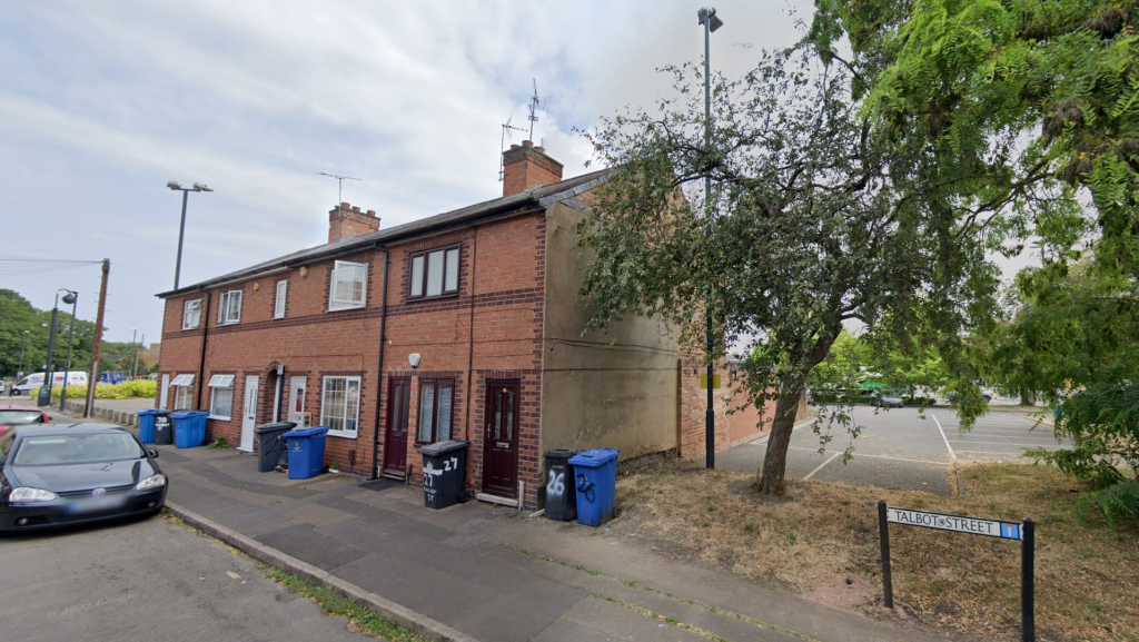
26 TALBOT STREET
DERBY, CITY OF DERBY DE1 1JN
£425 pcm
Property details
Floor area
35 m²
Council tax band
A
Deprivation
Decile 2 (5,562 of 33,755)
Street crime
1248 incidents within 1 mile (Apr 2026)
Key features
- Permit Parking
- First Floor Maisonette
Additional details
- Parking
- Yes
Description
Permit parking
First floor Maisonette
Listed by
Derby
Attain Properties Limited
Reference: 142806635
EPC Rating & Upgrade Cost
Fetching EPC data… Refresh this page in a moment.
Flood risk
Zone: 1
Risk: Low
Job (default Low)
EPC Graphs
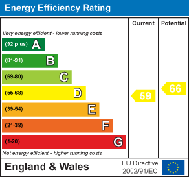
EE Rating
FENSA Certificates
This property has 1 FENSA certificate(s) on record, indicating window/door installations by FENSA-approved installers.
FENSA Certificate #3888620
Property Details
Street: 26 Talbot Street
Town: DERBY
Postcode: DE1 1JN
Installation Details
Items: 3 windows and 1 door
Certificate Issued: 17/07/2006
Work Completed: 01/07/2006
This certificate data was retrieved from FENSA's database
What is FENSA? FENSA (Fenestration Self-Assessment Scheme) is a government-authorised scheme that monitors building regulation compliance for replacement windows and doors. Certificates indicate that work was completed by FENSA-approved installers.
Rental Range
Estimated market rent for Derby. Low = conservative, Realistic = average, Optimistic = best case.
Based on Local Authority from postcode lookup → Derby.
LHA (30th percentile) floor for Derby: £449/mo (Apr 2025 – Mar 2026)
Location
Nearby
Nearest stations, universities and amenities (distance from property).
| Type | Name | Distance |
|---|---|---|
| Shop | M&S Motors Service | 0.1 miles |
| Shop | Derby Garage | 0.1 miles |
| Bus stop | Macklin Street | 0.1 miles |
| University | Derby Law School | 0.3 miles |
| University | Agard Court | 0.3 miles |
| Hospital | Florence Nightingale Community Hospital | 0.9 miles |
| Train station | Derby | 1.0 miles |
| Hospital | Kingsway Hospital | 1.2 miles |
| Train station | Peartree | 1.7 miles |
Street-level crime
| Category | Count |
|---|---|
| Violence and sexual offences | 436 |
| Anti-social behaviour | 143 |
| Public order | 137 |
| Shoplifting | 133 |
| Drugs | 113 |
| Criminal damage and arson | 76 |
| Other theft | 68 |
| Vehicle crime | 32 |
| Burglary | 27 |
| Robbery | 23 |
| Possession of weapons | 20 |
| Other crime | 15 |
| Bicycle theft | 13 |
| Theft from the person | 12 |
| Total incidents | 1248 |
Within 1 mile during Apr 2026. Source: data.police.uk (England & Wales).
Schools nearby
Nearest open schools with Ofsted ratings (England). Closed schools are not shown. Data from Get Information about Schools and Ofsted.
| Name | Type | Distance | Ofsted |
|---|---|---|---|
| Becket Primary School | Primary | 0.2 miles | Good — 18 May 2023 |
| Derby Cathedral School | Secondary | 0.3 miles | Good — 13 Feb 2023 |
| Castle School | Other | 0.5 miles | Good — 25 May 2016 |
| Ashgate Nursery School | Nursery | 0.5 miles | Good — 15 Mar 2013 |
| Central Community Nursery School | Nursery | 0.5 miles | Good — 4 Feb 2013 |
Rental Comparables
Residential lets from OpenRent and Rightmove for the area (same bedroom count). Use to validate rent estimates. Student lets are excluded.
| Title | Rent | Beds | Distance | As seen on |
|---|---|---|---|---|
| 1 Bed Flat, The Ashbourne, DE22 | £760/mo | 1 | 0.09 miles | OpenRent |
| 1 Bed Flat, Abbey Street, DE22 | £580/mo | 1 | 0.12 miles | OpenRent |
| 1 Bed Terraced House, Bakewell Street, DE22 | £600/mo | 1 | 0.16 miles | OpenRent |
| 1 Bed Flat, Celtic House, DE1 | £800/mo | 1 | 0.16 miles | OpenRent |
| Studio Flat, Jackson Street, DE22 | £925/mo | 1 | 0.19 miles | OpenRent |
| Studio Flat, Jackson Street, DE22 | £965/mo | 1 | 0.19 miles | OpenRent |
| Studio Flat, The Art House, DE1 | £650/mo | 1 | 0.24 miles | OpenRent |
| The Nightingale Quarter, 1 Sylvester Close, Derby | £925/mo | 1 | 0.7 miles | Rightmove |
Average rent: £776/mo (8 listings)