29 BURYMEAD
STEVENAGE, HERTFORDSHIRE SG1 4AX
£196,995
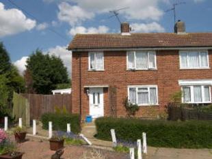
Photo 1
/ 1
Property details
Floor area
138 m²
EPC rating
C
Year built
England and Wales: 1950-1966
Last sold
£385,000 May 2023
Price per m²
£1,428/m²
Local average
£808,333 (-75.6%)
Deprivation
Decile 6 (18,996 of 33,755)
Street crime
203 incidents within 1 mile (Apr 2026)
Key features
- Semi Detached
- Three Bedrooms
- Corner Plot
- Kitchen/breakfast Room
- Conservatory
- Lovely Rear Garden
- Close To Old Town Centre
- Viewing Recommended
Description
Listed by
Stevenage
Putterills
Reference: 11905463
EPC Rating & Upgrade Cost
Current rating: C
Potential rating: B
Inspection date: 10/05/2023
Current heating cost: £1,183/year
Potential heating cost: £1,183/year
Est. upgrade cost to C: £4,500
Recommendations
- Solar photovoltaic panels, 2.5 kWp (£3,500 - £5,500)
Flood risk
Zone: 1
Risk: Low
Job (default Low)
FENSA Certificates
This property has 1 FENSA certificate(s) on record, indicating window/door installations by FENSA-approved installers.
FENSA Certificate #16489253 Recent
Property Details
Street: 29 Burymead
Town: STEVENAGE
Postcode: SG1 4AX
Installation Details
Items: 3 windows
Certificate Issued: 29/09/2024
Work Completed: 02/09/2024
This certificate data was retrieved from FENSA's database
What is FENSA? FENSA (Fenestration Self-Assessment Scheme) is a government-authorised scheme that monitors building regulation compliance for replacement windows and doors. Certificates indicate that work was completed by FENSA-approved installers.
Price history
| Event | Date | Price | % change |
|---|---|---|---|
| Sold | 26/05/2023 (3 years ago) | £385,000 | — |
Source: HM Land Registry Price Paid Data. Crown copyright.
Sold Comparables
Same street and nearby sales within 0.25 miles (last 5 years). Data from Land Registry Price Paid.
| Address | Price | Date | Type |
|---|---|---|---|
| 32 WHITNEY DRIVE, STEVENAGE, HERTFORDSHIRE, SG1 4BH | £250 | 19/01/2022 | Other |
| 68 WHITNEY DRIVE, STEVENAGE, HERTFORDSHIRE, SG1 4BJ | £950,000 | 21/09/2021 | Other |
Area average: £475,125 (2 sales)
Capital growth trend
Land Registry outcode average: last 12 months vs 5y and 10y ago (from sold prices).
House Price Index (HM Land Registry — official index, not sold-price averages): Stevenage. Series: All dwelling types. As of March 2026.
Rental Range
Estimated market rent for Stevenage. Low = conservative, Realistic = average, Optimistic = best case.
Based on Local Authority from postcode lookup → Stevenage.
LHA (30th percentile) floor for Stevenage & North Herts: £1,247/mo (Apr 2025 – Mar 2026)
Location
Nearby
Nearest stations, universities and amenities (distance from property).
| Type | Name | Distance |
|---|---|---|
| Bus stop | Bury Mead | 0.1 miles |
| Shop | WHSmith | 0.4 miles |
| Shop | Shades of Gray | 0.5 miles |
| Train station | Stevenage | 1.2 miles |
| Train station | Hitchin | 3.3 miles |
| Hospital | Unknown | 5.7 miles |
| University | University of Bedfordshire : Putteridge Bury Campus | 7.2 miles |
| University | University Of Bedfordshire | 9.1 miles |
| Hospital | Spire Hospital | 9.1 miles |
Street-level crime
| Category | Count |
|---|---|
| Violence and sexual offences | 97 |
| Anti-social behaviour | 29 |
| Public order | 18 |
| Other theft | 15 |
| Criminal damage and arson | 11 |
| Vehicle crime | 9 |
| Shoplifting | 7 |
| Burglary | 5 |
| Drugs | 5 |
| Other crime | 3 |
| Possession of weapons | 2 |
| Robbery | 1 |
| Theft from the person | 1 |
| Total incidents | 203 |
Within 1 mile during Apr 2026. Source: data.police.uk (England & Wales).
Schools nearby
Nearest open schools with Ofsted ratings (England). Closed schools are not shown. Data from Get Information about Schools and Ofsted.
| Name | Type | Distance | Ofsted |
|---|---|---|---|
| The Saint John Henry Newman Catholic School | Secondary | 0.3 miles | Good — 23 Feb 2015 |
| The Thomas Alleyne Academy | Secondary | 0.3 miles | Good — 1 Jul 2015 |
| Barclay Academy | Secondary | 0.3 miles | Good — 14 Jun 2023 |
| Almond Hill Junior School | Primary | 0.4 miles | Good — 30 Mar 2016 |
| Letchmore Infants' and Nursery School | Primary | 0.5 miles | Outstanding — 11 Sep 2024 |
Rental Comparables
Residential lets from OpenRent and Rightmove for the area (same bedroom count). Use to validate rent estimates. Student lets are excluded.
| Title | Rent | Beds | Distance | As seen on |
|---|---|---|---|---|
| 3 Bed Terraced House, Weston Road, SG1 | £1,825/mo | 3 | 0.48 miles | OpenRent |
| 3 Bed Semi-Detached House, Ellis Avenue, SG1 | £1,640/mo | 3 | 0.55 miles | OpenRent |
| 3 Bed Terraced House, Morecambe Close, SG1 | £1,595/mo | 3 | 0.58 miles | OpenRent |
| 3 Bed Semi-Detached House, Ellis Avenue, SG1 | £1,550/mo | 3 | 0.65 miles | OpenRent |
| 3 Bed Terraced House, Haycroft Road, SG1 | £1,650/mo | 3 | 0.68 miles | OpenRent |
| 3 Bed Semi-Detached House, Sish Lane, SG1 | £1,975/mo | 3 | 0.83 miles | OpenRent |
Average rent: £1,706/mo (6 listings)
Rent-driven metrics
Based on OpenRent comparables.
- Rent ratio — Monthly rent ÷ purchase price (1% rule). 1%+ = strong, 0.8–1% = okay, <0.8% = weak for cashflow.
- Max investor price — Rent ÷ 0.8%; the price at which rent would be 0.8% of price (Stoke-style target).
- Target investor price — Rent ÷ 1%; the price at which rent would be 1% of price (strong cashflow band).
- Gross yield — Annual rent as % of purchase price (no costs).
- Cost-to-rent — Price ÷ annual rent (from OpenRent comparables). Under 14× = strong, 14–16× = acceptable, 17×+ = compressed.
- Cashflow — Rent minus mortgage, 10% maintenance, £25/mo compliance. Assumes 75% LTV, 3.95% APR (5yr fixed), 25yr term.
- ROI — Annual profit ÷ cash in (deposit + 4% purchase costs).