Land At Scotia Road
Tunstall, Stoke-on-Trent, Staffordshire, ST6 4JD
/ 3
Property details
Tenure
FREEHOLD
Local average
£371,206 (-100%)
Deprivation
Decile 1 (1,397 of 33,755)
Street crime
446 incidents within 1 mile (Apr 2026)
Key features
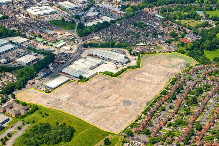
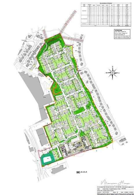
- Detailed planning permission for 227 dwellings, 93 care home apartments.
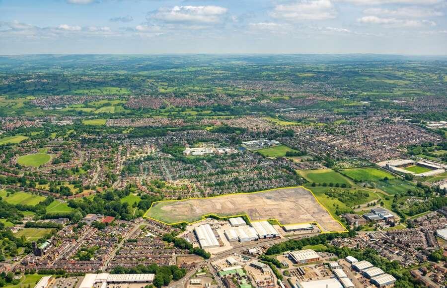
- Gross area extending to approximately 22.07 acres (8.93 hectares).
- Remediated development site with NHBC LQE Certification upon completion of sale.
- Excellent connectivity and regeneration potential.
Description
Historically, the site been used for mining purposes, with eight mine shafts identified across its area. However, the shafts have been grouted and capped with full remediation works scheduled for completion prior to the site’s disposal. One mine shaft remains untreated but is located in a POS area. An NHBC Land Quality Endorsement Certificate (LQE) will be obtained and shared with the buyer prior to the sale completing.
The remediation works are being carried out in accordance with the layout set out in the approved Proposed Site Plans, therefore any significant amendments to the layout may require further remediation works to be completed.
The site is located in Tunstall, one of the six towns that make up the city of Stoke-on-Trent in Staffordshire. Positioned along Scotia Road (A50), the site lies within close proximity to Tunstall and Burslem town centres, offering a range of local amenities, supermarkets, schools, healthcare facilities, and leisure.
The site offers excellent transport links, with the A500 dual carriageway approx. 1.5 miles away, providing swift access to Junction 16 of the M6 and the wider regional road network. Stoke-on-Trent railway station is 4.5 miles to the south, offering direct services to Manchester, Birmingham, and London. Bus stops on either side of Scotia Road adjacent to the site’s access providing direct services in to Stoke-on-Trent city centre and northbound to Crewe.
Manchester Airport is situated 34 miles north of the site whilst Birmingham Airport is located 60 miles south.
Listed by
Savills National , Manchester
Reference: 746617209297712
EPC Rating & Upgrade Cost
Fetching EPC data… Refresh this page in a moment.
Flood risk
Zone: 1
Risk: Low
Job (default Low)
Price history
No sales history found for this property in Land Registry Price Paid data.
Sold Comparables
Sold comparables data is not available for this property.
Capital growth trend
Land Registry outcode average: last 12 months vs 5y and 10y ago (from sold prices).
House Price Index (HM Land Registry — official index, not sold-price averages): Stoke-on-Trent. Series: All dwelling types. As of March 2026.
Rental Range
Estimated market rent for Stoke-on-Trent. Low = conservative, Realistic = average, Optimistic = best case.
Based on Local Authority from postcode lookup → Stoke-on-Trent.
LHA (30th percentile) floor for Staffordshire North: Apr 2025 – Mar 2026
Location
Address
Scotia Road
Nearby
Nearest stations, universities and amenities (distance from property).
| Type | Name | Distance |
|---|---|---|
| Bus stop | Dudson's factory | 0.1 miles |
| Shop | Specsavers | 0.2 miles |
| Bus stop | Unknown | 0.2 miles |
| Shop | Scotia Stores | 0.3 miles |
| Hospital | Haywood Hospital Walk-in Centre | 0.5 miles |
| Train station | Longport | 1.1 miles |
| Train station | Kidsgrove | 2.8 miles |
| Hospital | Royal Stoke University Hospital | 3.6 miles |
| University | Keele University | 4.7 miles |
| University | Buxton & Leek College | 8.3 miles |
Street-level crime
| Category | Count |
|---|---|
| Violence and sexual offences | 151 |
| Anti-social behaviour | 86 |
| Vehicle crime | 37 |
| Criminal damage and arson | 31 |
| Other theft | 29 |
| Shoplifting | 29 |
| Public order | 24 |
| Burglary | 21 |
| Drugs | 13 |
| Robbery | 8 |
| Other crime | 7 |
| Possession of weapons | 6 |
| Bicycle theft | 3 |
| Theft from the person | 1 |
| Total incidents | 446 |
Within 1 mile during Apr 2026. Source: data.police.uk (England & Wales).
Schools nearby
Nearest open schools with Ofsted ratings (England). Closed schools are not shown. Data from Get Information about Schools and Ofsted.
| Name | Type | Distance | Ofsted |
|---|---|---|---|
| St Wilfrid's Catholic Primary School | Primary | 0.2 miles | Good — 12 Jun 2017 |
| The Nest | Other | 0.3 miles | Good — 13 Sep 2023 |
| Co-op Academy Stoke-On-Trent | Secondary | 0.4 miles | Good — 27 Mar 2013 |
| Active Wellbeing School | Other | 0.4 miles | Requires improvement — 29 Nov 2023 |
| St Mary's Church of England Primary School | Primary | 0.4 miles | Outstanding — 13 Jun 2024 |
Rental Comparables
Residential lets from OpenRent and Rightmove for the area. Bedroom counts vary — use the Beds column to compare like-for-like lets. Student lets are excluded.
| Title | Rent | Beds | Distance | As seen on |
|---|---|---|---|---|
| King William Street, Tunstall | £750/mo | 2 | 0.1 miles | Rightmove |
| Pinnox Street, Stoke-On-Trent | £850/mo | 2 | 0.17 miles | Rightmove |
| The Boulevard, Stoke-on-Trent, ST6 | £595/mo | — | 0.28 miles | Rightmove |
| High Street, Tunstall | £550/mo | — | 0.33 miles | Rightmove |
| High Street, Stoke-on-Trent, Staffordshire, ST6 | £550/mo | 1 | 0.39 miles | Rightmove |
| Machin Street, Tunstall | £750/mo | 2 | 0.41 miles | Rightmove |
| Stanley Street, Tunstall | £850/mo | 3 | 0.45 miles | Rightmove |
| Federation Road, Burslem | £625/mo | 2 | 0.45 miles | Rightmove |
| Lancashire Court, Federation Road, Burslem, Stoke-on-Trent, ST6 | £600/mo | 1 | 0.48 miles | Rightmove |
| Victoria Park Road, Stoke-on-trent, ST6 6DY | £850/mo | 2 | 0.58 miles | Rightmove |
| Hamil Road, Stoke-On-Trent | £850/mo | 3 | 0.65 miles | Rightmove |
| Stanfield Road, Stoke-On-Trent, ST6 | £700/mo | 2 | 0.65 miles | Rightmove |
| Hamil Road, Burslem | £745/mo | 2 | 0.66 miles | Rightmove |
| Westport Road, Stoke-On-Trent, ST6 | £625/mo | 1 | 0.69 miles | Rightmove |
| May Street, Burslem, Stoke-on-Trent, Staffordshire, ST6 | £625/mo | 2 | 0.71 miles | Rightmove |
| St Aidans Street, Stoke-on-trent | £750/mo | 2 | 0.73 miles | Rightmove |
| Moorland Road, Burslem, Stoke-on-Trent | £715/mo | 2 | 0.73 miles | Rightmove |
| Bond Street, Tunstall | £750/mo | 2 | 0.75 miles | Rightmove |
| Lyndhurst Street, Burslem | £695/mo | 2 | 0.76 miles | Rightmove |
| Jackfield Street,Burslem, Stoke-on-Trent | £700/mo | 2 | 0.76 miles | Rightmove |
Average rent: £746/mo (49 listings)
Rent-driven metrics
Based on OpenRent comparables.
- Rent ratio — Monthly rent ÷ purchase price (1% rule). 1%+ = strong, 0.8–1% = okay, <0.8% = weak for cashflow.
- Max investor price — Rent ÷ 0.8%; the price at which rent would be 0.8% of price (Stoke-style target).
- Target investor price — Rent ÷ 1%; the price at which rent would be 1% of price (strong cashflow band).
- Gross yield — Annual rent as % of purchase price (no costs).
- Cashflow — Rent minus mortgage, 10% maintenance, £25/mo compliance. Assumes 75% LTV, 3.95% APR (5yr fixed), 25yr term.
- ROI — Annual profit ÷ cash in (deposit + 4% purchase costs).
Enter House Number
Enter the house number to help us retrieve more accurate pricing history and property data.
Please log in to submit or correct the house number for this listing.
Log in to continue