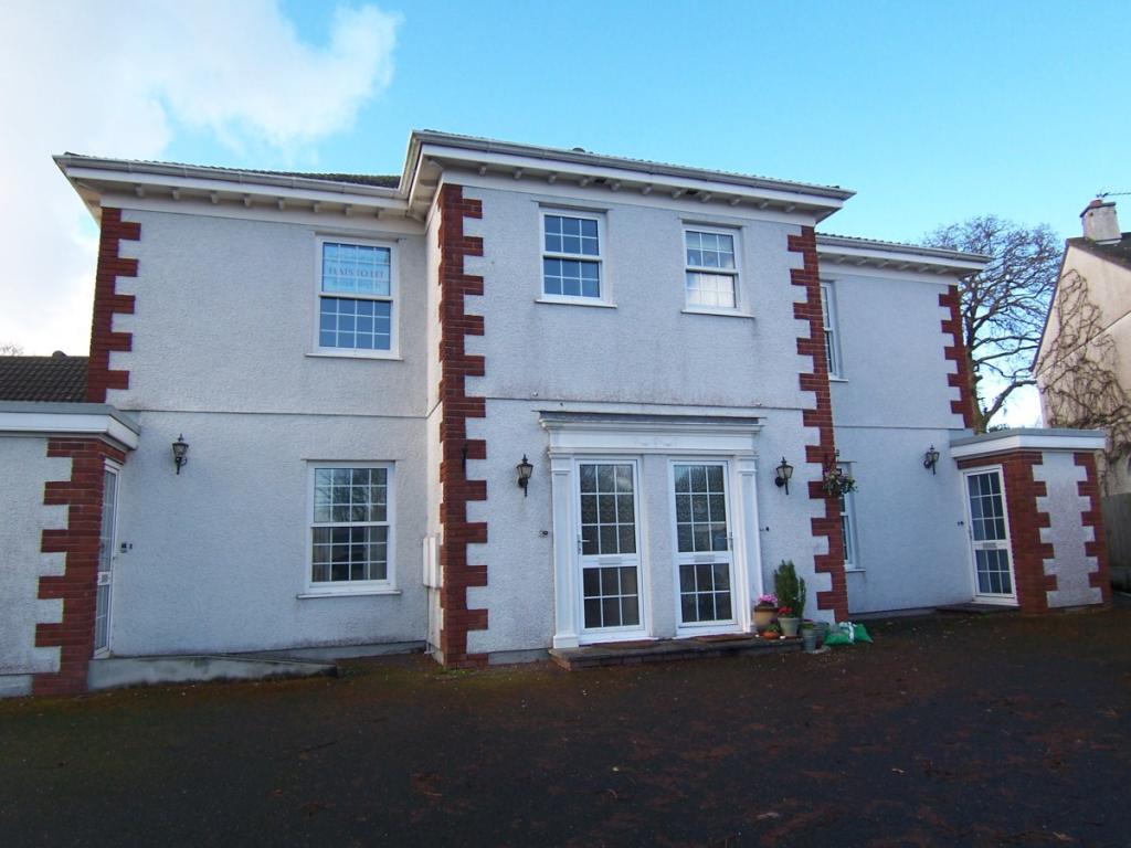
FLAT 4
BUCKLERS HOUSE, BUCKLERS LANE, ST AUSTELL, CORNWALL PL25 3JN
£510 pcm
Property details
Floor area
53 m²
EPC rating
C
Year built
England and Wales: 1930-1949
Deprivation
Decile 4 (12,974 of 33,755)
Street crime
106 incidents within 1 mile (Apr 2026)
Additional details
- Parking
- Yes
Description
* AVAILABLE MID DECEMBER
* Upvc Double Glazing
* Fitted Kitchen
* Bathroom
* Well Proportioned Lounge/Dining Room
* Two Bedroom Accommodation
* Allocated Parking Plus Additional Parking
* Anticipated as a Long Term Let
Listed by
Cornwall
Countrywide UK Lettings - Connells
Reference: 32146600
EPC Rating & Upgrade Cost
Current rating: C
Potential rating: C
Inspection date: 25/08/2020
Expiry date: 24/08/2030
Current heating cost: £414/year
Potential heating cost: £316/year
Recommendations
- 50 mm internal or external wall insulation (14,000)
- Heat recovery system for mixer showers (725)
Flood risk
Zone: 1
Risk: Low
Job (default Low)
Rental Range
Estimated market rent for Cornwall. Low = conservative, Realistic = average, Optimistic = best case.
Based on Local Authority from postcode lookup → Cornwall.
Location
Address
Cassiterite Close
Nearby
Nearest stations, universities and amenities (distance from property).
| Type | Name | Distance |
|---|---|---|
| Shop | Eurocell | 0.0 miles |
| Shop | Plumbase | 0.0 miles |
| Bus stop | Bucklers Lane | 0.1 miles |
| Bus stop | Chapel Field | 0.1 miles |
| Hospital | St Austell Community Hospital | 1.3 miles |
| Train station | St Austell | 1.3 miles |
| Train station | Par | 2.6 miles |
| Hospital | Bodmin Hospital | 8.6 miles |
Street-level crime
| Category | Count |
|---|---|
| Violence and sexual offences | 49 |
| Criminal damage and arson | 18 |
| Other theft | 8 |
| Anti-social behaviour | 7 |
| Public order | 7 |
| Other crime | 4 |
| Vehicle crime | 3 |
| Burglary | 2 |
| Drugs | 2 |
| Robbery | 2 |
| Shoplifting | 2 |
| Possession of weapons | 1 |
| Theft from the person | 1 |
| Total incidents | 106 |
Within 1 mile during Apr 2026. Source: data.police.uk (England & Wales).
Schools nearby
Nearest open schools with Ofsted ratings (England). Closed schools are not shown. Data from Get Information about Schools and Ofsted.
| Name | Type | Distance | Ofsted |
|---|---|---|---|
| Bishop Bronescombe CofE School | Primary | 0.3 miles | Good — 27 Sep 2022 |
| Charlestown Primary School | Primary | 0.5 miles | — (Inspected (no overall grade)) |
| Sandy Hill Academy | Primary | 0.5 miles | Outstanding — 23 Mar 2017 |
| Penrice Academy | Secondary | 0.6 miles | Outstanding — 2 Apr 2014 |
| Mount Charles School | Primary | 0.8 miles | Good — 24 Nov 2011 |
Rental Comparables
Loading rental comparables for this postcode. Refresh in a few minutes.