Curtis Cottage
HIGH STREET, FARINGDON, UFFINGTON, OXFORDSHIRE SN7 7RP
£1,550 pcm
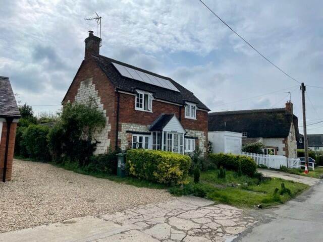


Photo 1 Photo 2 Photo 3 Photo 4 Photo 5 Photo 6 Photo 7 Photo 8 Photo 9 Photo 10 Photo 11 Photo 12
/ 12
Property details
Floor area
113 m²
Deprivation
Decile 7 (20,703 of 33,755)
Street crime
3 incidents within 1 mile (Apr 2026)
Key features
- Stunning gardens
- Range Cooker
- Oil central heating & wood burner
- 3 Bedrooms
- 3 Reception rooms
- Conservatory Leading Onto Enclosed Rear Garden
- Greenhouse
- Parking and garage
- a well behaved pet may be considered
- Available July - unfurnished
Additional details
- Parking
- Yes
- Garden
- Yes
Description
The cottage offers lots of charm and is conveniently located to all local amenities
Good sized rooms with a cosy log burner to the sitting room and a range cooker in the Kitchen.
The property benefits from a conservatory that looks over the beautiful mature gardens.
Listed by
Wantage
Preece and Co (UK) limited
Reference: 147301529
EPC ratings on this postcode
We don't have a matched EPC for this property yet. Below are efficiency scores and details for other addresses on this postcode.
| Address | Current | Potential | Floor area | Age band | Type |
|---|---|---|---|---|---|
| 2 New Cottages, High Street, Uffington, FARINGDON | 58 | 82 | 79 m² | England and Wales: 1967-1975 | Detached |
| Apple Tree Cottage, High Street, Uffington, FARINGDON | 40 | 73 | 96 m² | England and Wales: 1950-1966 | Detached |
| Apple Tree Cottage, High Street, Uffington, FARINGDON | 39 | 85 | 80 m² | England and Wales: 1950-1966 | Detached |
| Brook Cottage, High Street, Uffington, FARINGDON | 48 | 68 | 133 m² | England and Wales: before 1900 | Detached |
| Curtis Cottage, High Street, Uffington, FARINGDON | 65 | 97 | 113 m² | England and Wales: before 1900 | Detached |
| Janecroft, High Street, Uffington, FARINGDON | 46 | 76 | 131 m² | England and Wales: 1967-1975 | Detached |
| Long Thatch, High Street, Uffington, FARINGDON | 54 | 63 | 215 m² | England and Wales: before 1900 | Detached |
| Packers Forge, High Street, Uffington, FARINGDON | 37 | 72 | 169 m² | England and Wales: before 1900 | Detached |
| Pear Tree Cottage, High Street, Uffington, FARINGDON | 48 | 69 | 215 m² | England and Wales: before 1900 | Detached |
| Pear Tree Cottage, High Street, Uffington, FARINGDON | 46 | 73 | 229 m² | England and Wales: before 1900 | Detached |
| The Anchorage, High Street, Uffington, FARINGDON | 86 | 94 | 152 m² | — | Detached |
| The Coach House, High Street, Uffington, FARINGDON | 57 | 67 | 187 m² | England and Wales: 1983-1990 | Detached |
| The Coach House, High Street, Uffington, FARINGDON | 38 | 73 | 155 m² | England and Wales: 1967-1975 | Detached |
| The Sombornes, High Street, Uffington, FARINGDON | 53 | 71 | 184 m² | England and Wales: 1991-1995 | Detached |
| Top Corner, High Street, Uffington, FARINGDON | 34 | 41 | 159 m² | England and Wales: 1967-1975 | Detached |
Flood risk
Zone: 1
Risk: Low
Job (default Low)
Floorplans

Floorplan 1
EPC Graphs

EPC 1
Rental Range
Estimated market rent for Vale of White Horse. Low = conservative, Realistic = average, Optimistic = best case.
Based on Local Authority from postcode lookup → Vale of White Horse.
LHA (30th percentile) floor for Coventry: £773/mo (Apr 2025 – Mar 2026)
Location
Address
High Street
Nearby
Nearest stations, universities and amenities (distance from property).
| Type | Name | Distance |
|---|---|---|
| Bus stop | Shotover Corner | 0.1 miles |
| Shop | Absolutely Gorgeous | 3.5 miles |
| Shop | Watchfield Opticians | 3.5 miles |
| Hospital | Wantage Community Hospital | 6.1 miles |
| University | University of Oxford | 7.9 miles |
| Train station | Richard Jefferies Halt | 8.7 miles |
| Train station | Lakeside | 8.8 miles |
| University | Royal Agricultural University (Cultural Heritage Institute) | 10.3 miles |
| Hospital | Marlborough House | 10.8 miles |
Street-level crime
| Category | Count |
|---|---|
| Violence and sexual offences | 2 |
| Criminal damage and arson | 1 |
| Total incidents | 3 |
Within 1 mile during Apr 2026. Source: data.police.uk (England & Wales).
Schools nearby
Nearest open schools with Ofsted ratings (England). Closed schools are not shown. Data from Get Information about Schools and Ofsted.
| Name | Type | Distance | Ofsted |
|---|---|---|---|
| Uffington Church of England Primary School | Primary | 0.2 miles | Good — 27 Sep 2022 |
| Longcot and Fernham Church of England Primary School | Primary | 2.3 miles | Requires improvement — 15 Jan 2023 |
| Shellingford Church of England (Voluntary Aided) School | Primary | 2.9 miles | Good — 24 May 2012 |
| Folly View Primary | Primary | 3.5 miles | Good — 15 Mar 2013 |
| Stanford In the Vale CofE Primary School | Primary | 3.5 miles | Good — 13 Mar 2013 |
Rental Comparables
Rental comparables are temporarily unavailable while listing-site fetches are paused. Try again later.
Enter House Number
Enter the house number to help us retrieve more accurate pricing history and property data.
Please log in to submit or correct the house number for this listing.
Log in to continue