3 WOODWAY
BIRMINGHAM, BIRMINGHAM, WEST MIDLANDS B24 0AH
Listing type
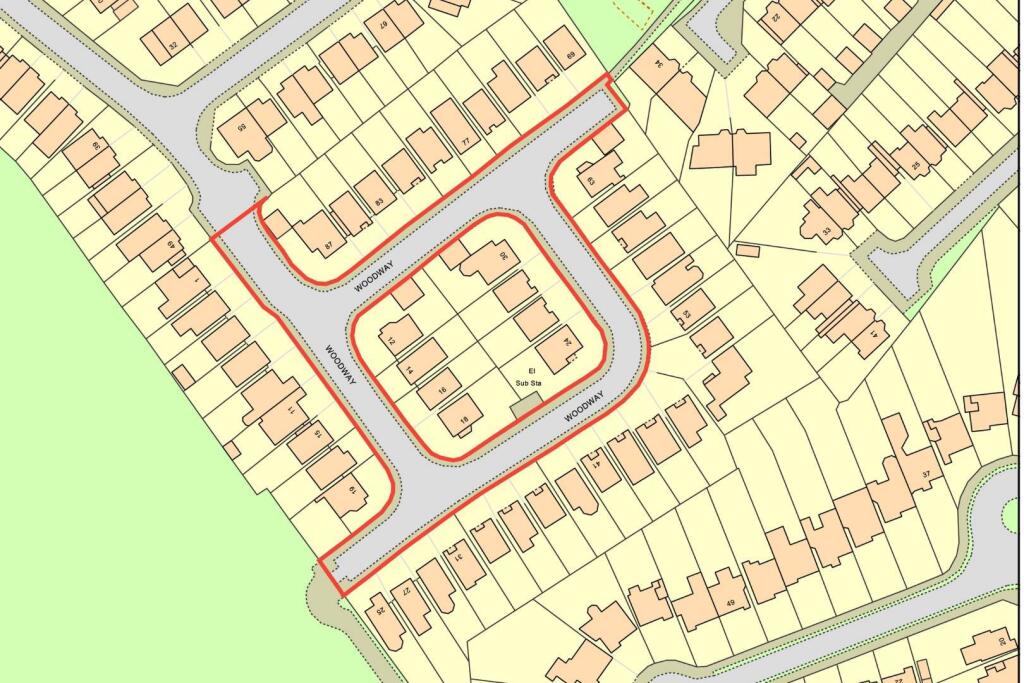
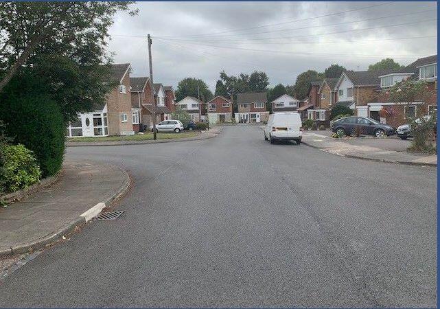
Photo 1 Photo 2
/ 2
Property details
Listing category
Auction
Tenure
FREEHOLD
Floor area
87 m²
Year built
England and Wales: 1967-1975
Last sold
£180,000 Feb 2006
Price per m²
£1/m²
Local average
£214,500 (-100%)
Deprivation
Decile 3 (7,518 of 33,755)
Street crime
404 incidents within 1 mile (Apr 2026)
Key features
- View more: underthehammer.com
Description
Land to the North of, Grange Road, Erdington, Birmingham, B24 0AH - Freehold.
An excellent opportunity to acquire a freehold parcel of land located within an established residential setting in Erdington, Birmingham.
Land Overview
This land outlined in red surrounds a quiet cul-de-sac known as Woodway, comprising well-positioned frontages and access routes that serve multiple residential properties.
Location Overview
The land offers easy access to the M6 motorway, A38, local bus routes, and nearby rail stations including Chester Road and Erdington—perfectly positioned for commuters.
Here's what to do next
Visit - Our website and view the auction terms.View - Book a viewing directly through our website.Register - Get registered prior to the auction opening date.Legal Pack - Download and view the legal pack to find out all the relevant information.Prior Auction Offer - Want it now? Submit a prior auction offer through our website. All offer's go direct to the seller.Bidding - Everything is completed online through the website and the intuitive bidding controls.If you would like your property to go into our next auction then contact our auction experts on or submit a valuation on our website
Listed by
Covering Nationwide
ADVANCED NATIONWIDE LIMITED
Reference: 164867852
EPC Rating & Upgrade Cost
Fetching EPC data… Refresh this page in a moment.
Flood risk
Zone: 2
Risk: In flood risk area
Environment Agency Flood Risk Areas (APSFR)
FENSA Certificates
This property has 1 FENSA certificate(s) on record, indicating window/door installations by FENSA-approved installers.
FENSA Certificate #2403060
Property Details
Street: 3 Woodway
Town: BIRMINGHAM
Postcode: B24 0AH
Installation Details
Items: 7 windows
Certificate Issued: 17/01/2005
Work Completed: 26/07/2004
This certificate data was retrieved from FENSA's database
What is FENSA? FENSA (Fenestration Self-Assessment Scheme) is a government-authorised scheme that monitors building regulation compliance for replacement windows and doors. Certificates indicate that work was completed by FENSA-approved installers.
Price history
| Event | Date | Price | % change |
|---|---|---|---|
| Sold | 06/02/2006 (20 years ago) | £180,000 | — |
Source: HM Land Registry Price Paid Data. Crown copyright.
Sold Comparables
Sold comparables data is not available for this property.
Capital growth trend
Land Registry outcode average: last 12 months vs 5y and 10y ago (from sold prices).
House Price Index (HM Land Registry — official index, not sold-price averages): Birmingham. Series: All dwelling types. As of March 2026.
Rental Range
Estimated market rent for Birmingham. Low = conservative, Realistic = average, Optimistic = best case.
Based on Local Authority from postcode lookup → Birmingham.
LHA (30th percentile) floor for Birmingham: Apr 2025 – Mar 2026
Location
Nearby
Nearest stations, universities and amenities (distance from property).
| Type | Name | Distance |
|---|---|---|
| Hospital | John Taylor Hospice | 0.1 miles |
| Bus stop | Grange Rd / Playing Field | 0.1 miles |
| Shop | Tesco Express | 0.4 miles |
| Shop | Coral | 0.4 miles |
| Train station | Chester Road | 0.6 miles |
| Train station | Erdington | 0.6 miles |
| Hospital | Ardenleigh Hospital | 1.0 miles |
| University | BCU Oscott Gardens | 3.0 miles |
| University | Maryvale Institute | 3.2 miles |
Street-level crime
| Category | Count |
|---|---|
| Violence and sexual offences | 156 |
| Shoplifting | 57 |
| Criminal damage and arson | 30 |
| Public order | 27 |
| Vehicle crime | 27 |
| Drugs | 26 |
| Other theft | 19 |
| Robbery | 18 |
| Burglary | 15 |
| Anti-social behaviour | 10 |
| Possession of weapons | 10 |
| Other crime | 4 |
| Theft from the person | 4 |
| Bicycle theft | 1 |
| Total incidents | 404 |
Within 1 mile during Apr 2026. Source: data.police.uk (England & Wales).
Schools nearby
Nearest open schools with Ofsted ratings (England). Closed schools are not shown. Data from Get Information about Schools and Ofsted.
| Name | Type | Distance | Ofsted |
|---|---|---|---|
| Yenton Primary School | Primary | 0.1 miles | Good — 5 Mar 2024 |
| St Edmund Campion Catholic School | Secondary | 0.3 miles | Good — 6 Feb 2018 |
| Penns Primary School | Primary | 0.4 miles | Good — 20 Feb 2012 |
| Abbey Catholic Primary School | Primary | 0.5 miles | Good — 6 Jul 2018 |
| Highclare School | Other | 0.5 miles | — (No rating) |
Rental Comparables
Residential lets from OpenRent and Rightmove for the area. Bedroom counts vary — use the Beds column to compare like-for-like lets. Student lets are excluded.
| Title | Rent | Beds | Distance | As seen on |
|---|---|---|---|---|
| 1 Bed Flat, Chester Road, B24 | £2,500/mo | 1 | 0.65 miles | OpenRent |
Average rent: £2,500/mo (1 listing)
Rent-driven metrics
Based on OpenRent comparables.
- Rent ratio — Monthly rent ÷ purchase price (1% rule). 1%+ = strong, 0.8–1% = okay, <0.8% = weak for cashflow.
- Max investor price — Rent ÷ 0.8%; the price at which rent would be 0.8% of price (Stoke-style target).
- Target investor price — Rent ÷ 1%; the price at which rent would be 1% of price (strong cashflow band).
- Gross yield — Annual rent as % of purchase price (no costs).
- Cashflow — Rent minus mortgage, 10% maintenance, £25/mo compliance. Assumes 75% LTV, 3.95% APR (5yr fixed), 25yr term.
- ROI — Annual profit ÷ cash in (deposit + 4% purchase costs).