75 NUTSHALLING AVENUE
SOUTHAMPTON, ROWNHAMS, HAMPSHIRE SO16 8AY
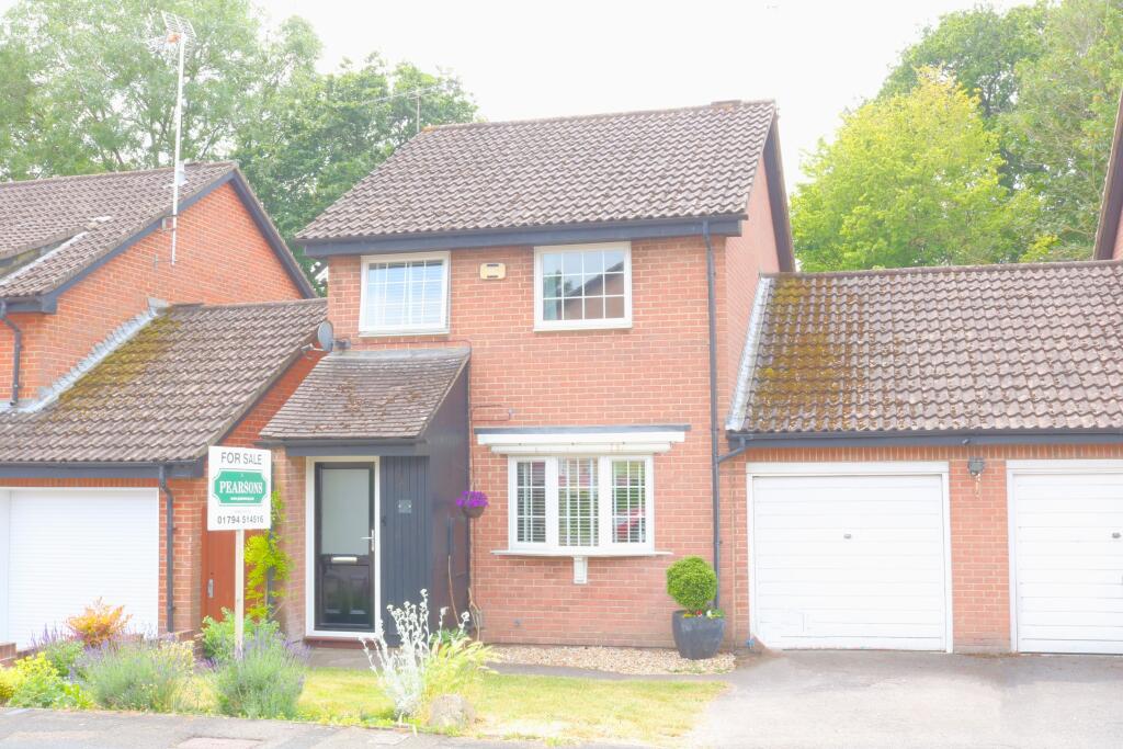
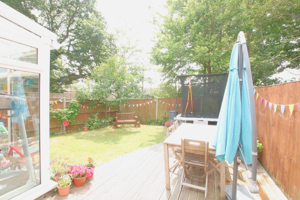
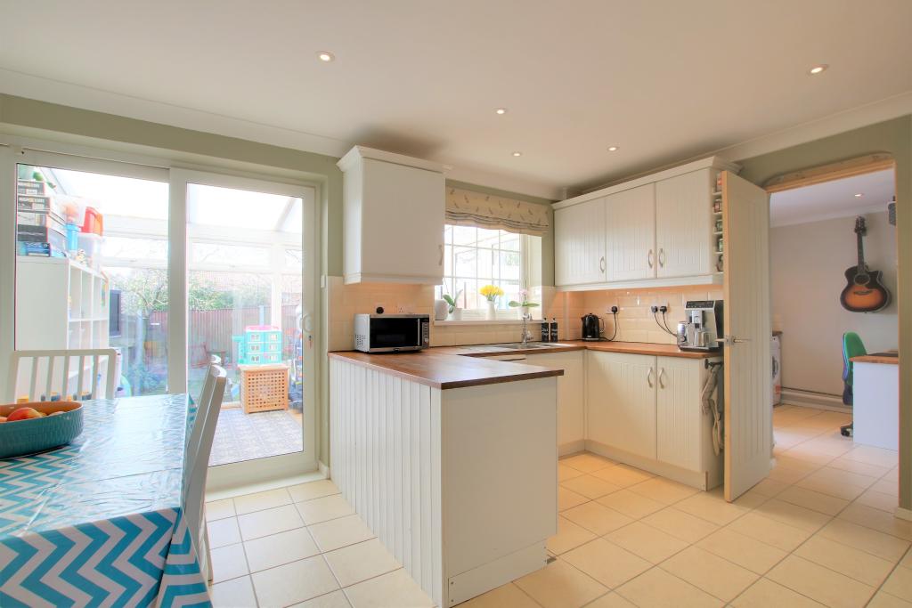

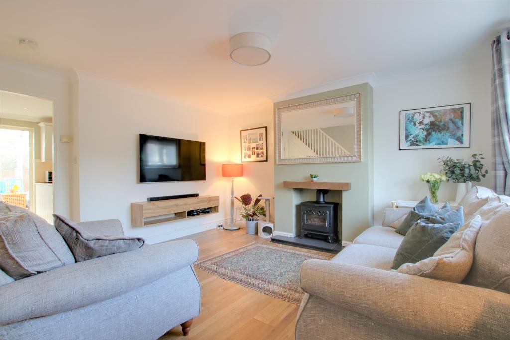
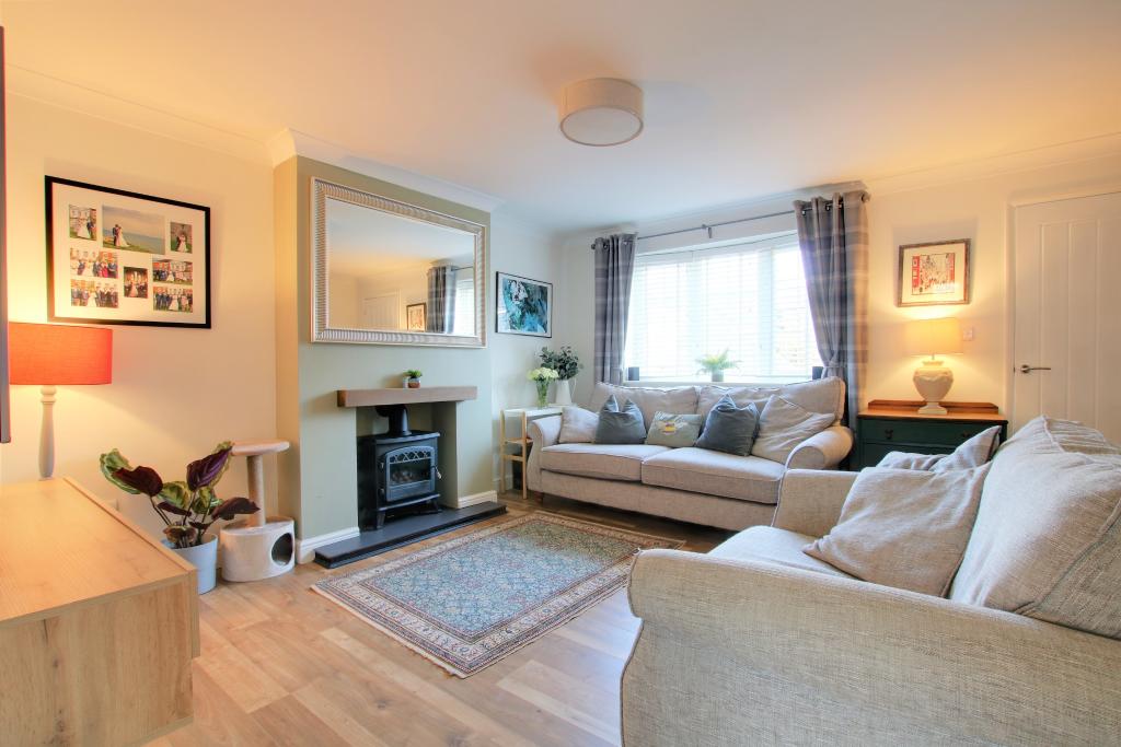

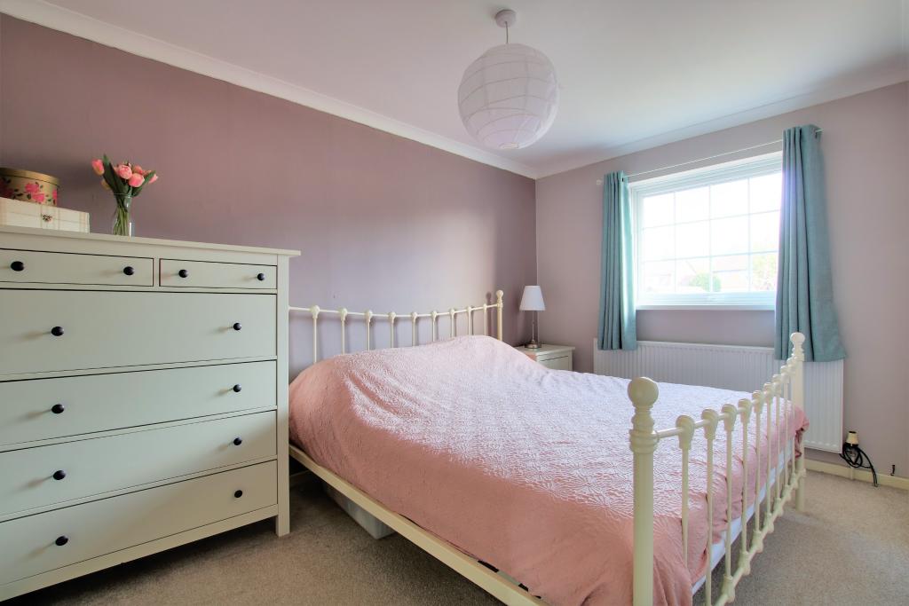
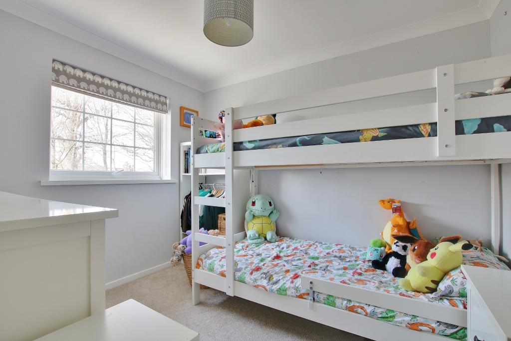


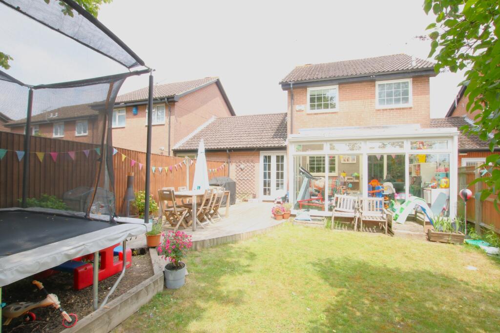
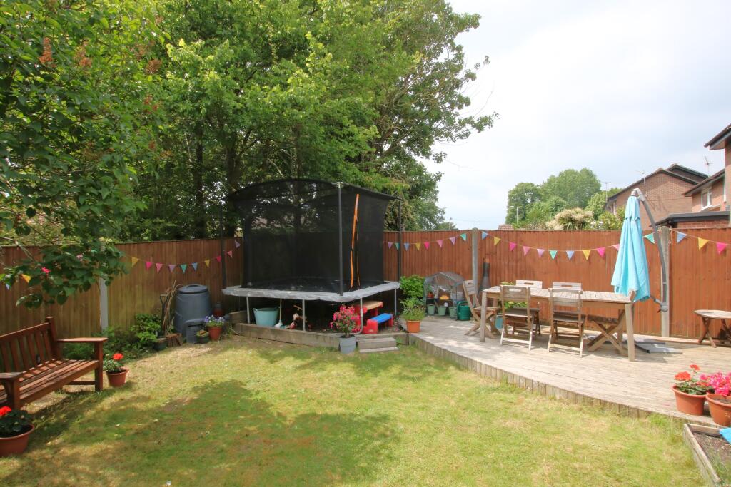
Photo 1 Photo 2 Photo 3 Photo 4 Photo 5 Photo 6 Photo 7 Photo 8 Photo 9 Photo 10 Photo 11 Photo 12 Photo 13
/ 13
Property details
Tenure
FREEHOLD
Floor area
87 m²
Council tax band
D
EPC rating
D
Year built
England and Wales: 1976-1982
Last sold
£385,000 Jan 2026
Price per m²
£4,310/m²
Local average
£582,028 (-35.6%)
Deprivation
Decile 10 (33,481 of 33,755)
Street crime
168 incidents within 1 mile (Apr 2026)
Key features
- A Link Detachaed Family Home
- 3 Bedrooms
- Kitchen/Dining Room
- Study/Utility Room
- Family Bathroom
- Enclosed Rear Garden
- Garage
- Parking
Additional details
- Parking
- Yes
- Garden
- Yes
Description
Rownhams is an ever-popular village on the edge of Southampton, and well placed for access onto the M27/M3 motorway interchange, the New Forest, and Southampton Airport Parkway which connects to London Waterloo in 70 minutes. Locally there are good amenities to include an excellent primary school, shops, and pub/restaurants, with more comprehensive amenities at Southampton and Romsey both within around four miles. The property also falls within the catchment area for Mountbatten School in Romsey.
ENTRANCE PORCH:
Front door. Door to:
SITTING ROOM:
Radiator. Double glazed bow window to the front aspect. Door opening to:
KITCHEN/DINING ROOM:
Double glazed window to rear aspect. Radiator. Range of wall and floor level cupboards with fitted work surfaces and neat tiling. Space for a range of appliances. Opening to:
UTILITY ROOM/STUDY:
French doors opening onto the rear garden.
CONSERVATORY:
French doors opening into the rear garden.
FIRST FLOOR:
LANDING:
Access to part boarded loft space. Doors to all first-floor rooms
MASTER BEDROOM:
Radiator. Double glazed window to front aspect. Built-in storage.
BEDROOM TWO:
Radiator. Double glazed windows to rear aspect.
BEDROOM THREE:
Radiator. Double glazed windows to front aspect.
FAMILY BATHROOM:
Bath with shower over, low level WC and semi-recessed wash hand basin. Towel radiator. Double glazed window to rear aspect.
OUTSIDE:
The rear garden is enclosed with spacious lawn, decked entertaining areas and established planting with an excellent degree of privacy and a sunny aspect.
GARAGE:
Up and over door. Driveway to the front.
TEST VALLEY COUNCIL TAX:
Band: D, Price: £1883.41 for the year 2022/23
Listed by
Romsey
Pearsons
Reference: 131593643
EPC Rating & Upgrade Cost
Current rating: D
Potential rating: C
Inspection date: 29/08/2025
Expiry date: 28/08/2035
Current heating cost: £875/year
Potential heating cost: £802/year
Est. upgrade cost to C: £16,500
Recommendations
- Floor insulation (solid floor) (£5,000 - £10,000)
- Solar photovoltaic panels, 2.5 kWp (£8,000 - £10,000)
Flood risk
Zone: 1
Risk: Low
Job (default Low)
Floorplans

Floorplan 1
EPC Graphs
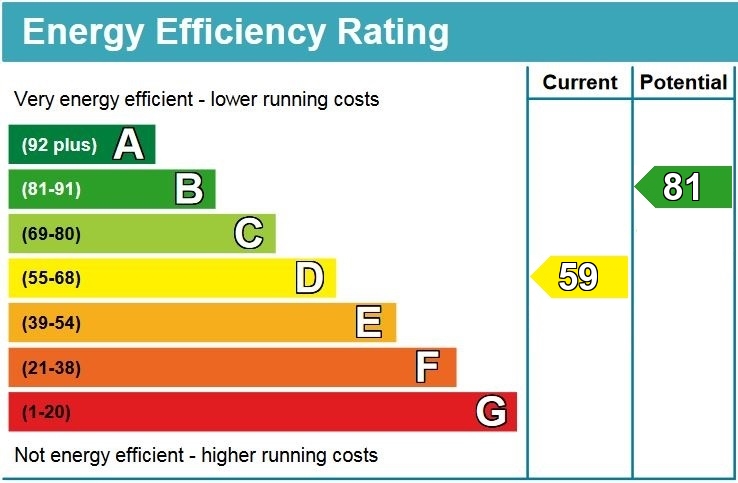
EPC
Price history
88% since 2003
| Event | Date | Price | % change |
|---|---|---|---|
| Sold | 30/01/2026 (4 months ago) | £385,000 | +57.1% |
| Sold | 21/02/2014 (12 years ago) | £245,000 | -2% |
| Sold | 08/10/2007 (18 years ago) | £249,999 | +22% |
| Sold | 26/09/2003 (22 years ago) | £205,000 | — |
Source: HM Land Registry Price Paid Data. Crown copyright.
Sold Comparables
Same street and nearby sales within 0.25 miles (last 5 years). Data from Land Registry Price Paid.
| Address | Price | Date | Type |
|---|---|---|---|
| 59 NUTSHALLING AVENUE, ROWNHAMS, SOUTHAMPTON, TEST VALLEY, HAMPSHIRE, SO16 8AY | £595,000 | 26/06/2025 | Detached |
| 18 BAKERS DROVE, ROWNHAMS, SOUTHAMPTON, TEST VALLEY, HAMPSHIRE, SO16 8AD | £510,000 | 14/03/2025 | Detached |
| 2 BAKERS DROVE, ROWNHAMS, SOUTHAMPTON, TEST VALLEY, HAMPSHIRE, SO16 8AD | £600,000 | 30/06/2023 | Detached |
| 99 NUTSHALLING AVENUE, ROWNHAMS, SOUTHAMPTON, TEST VALLEY, HAMPSHIRE, SO16 8AY | £540,000 | 28/06/2023 | Detached |
| 71 NUTSHALLING AVENUE, ROWNHAMS, SOUTHAMPTON, TEST VALLEY, HAMPSHIRE, SO16 8AY | £470,000 | 23/06/2023 | Detached |
| 11 JEFFRIES CLOSE, ROWNHAMS, SOUTHAMPTON, TEST VALLEY, HAMPSHIRE, SO16 8DS | £485,000 | 11/05/2023 | Detached |
| 24 BOSSINGTON CLOSE, ROWNHAMS, SOUTHAMPTON, TEST VALLEY, HAMPSHIRE, SO16 8DW | £477,500 | 13/12/2022 | Detached |
| 20 JEFFRIES CLOSE, ROWNHAMS, SOUTHAMPTON, TEST VALLEY, HAMPSHIRE, SO16 8DS | £475,000 | 18/11/2022 | Detached |
| 12 RUFUS CLOSE, ROWNHAMS, SOUTHAMPTON, TEST VALLEY, HAMPSHIRE, SO16 8LR | £482,500 | 11/11/2022 | Detached |
| 7 JEFFRIES CLOSE, ROWNHAMS, SOUTHAMPTON, TEST VALLEY, HAMPSHIRE, SO16 8DS | £529,500 | 19/08/2022 | Detached |
| 35 RUFUS CLOSE, ROWNHAMS, SOUTHAMPTON, TEST VALLEY, HAMPSHIRE, SO16 8LR | £625,000 | 23/06/2022 | Detached |
| CAPRIQUA TOOGOODS WAY, NURSLING, SOUTHAMPTON, TEST VALLEY, HAMPSHIRE, SO16 0XL | £490,000 | 13/05/2022 | Detached |
| ROSEGARTH TOOGOODS WAY, NURSLING, SOUTHAMPTON, TEST VALLEY, HAMPSHIRE, SO16 0XL | £510,000 | 20/04/2022 | Detached |
| AMGIST TOOGOODS WAY, NURSLING, SOUTHAMPTON, TEST VALLEY, HAMPSHIRE, SO16 0XL | £490,000 | 22/10/2021 | Detached |
| 20 RUFUS CLOSE, ROWNHAMS, SOUTHAMPTON, TEST VALLEY, HAMPSHIRE, SO16 8LR | £635,000 | 13/08/2021 | Detached |
Area average: £527,633 (15 sales)
Capital growth trend
Land Registry outcode average: last 12 months vs 5y and 10y ago (from sold prices).
House Price Index (HM Land Registry — official index, not sold-price averages): Test Valley. Series: Detached. As of March 2026.
Rental Range
Estimated market rent for Test Valley. Low = conservative, Realistic = average, Optimistic = best case.
Based on Local Authority from postcode lookup → Test Valley.
LHA (30th percentile) floor for Southampton: £1,072/mo (Apr 2025 – Mar 2026)
Location
Nearby
Nearest stations, universities and amenities (distance from property).
| Type | Name | Distance |
|---|---|---|
| Bus stop | The Balmoral | 0.1 miles |
| Shop | Co-op Food | 0.2 miles |
| Shop | Unknown | 0.2 miles |
| Hospital | Princess Anne Hospital | 1.3 miles |
| University | South Academic Block | 1.3 miles |
| Hospital | Southampton General Hospital | 1.4 miles |
| Train station | Redbridge | 1.9 miles |
| Train station | Totton | 2.2 miles |
| University | Boldrewood Innovation Campus | 2.4 miles |
Street-level crime
| Category | Count |
|---|---|
| Violence and sexual offences | 44 |
| Anti-social behaviour | 39 |
| Vehicle crime | 16 |
| Criminal damage and arson | 14 |
| Public order | 13 |
| Shoplifting | 10 |
| Burglary | 9 |
| Other theft | 8 |
| Drugs | 4 |
| Other crime | 4 |
| Robbery | 3 |
| Possession of weapons | 2 |
| Theft from the person | 2 |
| Total incidents | 168 |
Within 1 mile during Apr 2026. Source: data.police.uk (England & Wales).
Schools nearby
Nearest open schools with Ofsted ratings (England). Closed schools are not shown. Data from Get Information about Schools and Ofsted.
| Name | Type | Distance | Ofsted |
|---|---|---|---|
| Rownhams St John's Church of England Primary School | Primary | 0.2 miles | Good — 28 Jun 2023 |
| The Cedar School | Other | 0.2 miles | Good — 27 Jun 2014 |
| Fairisle Infant and Nursery School | Primary | 0.4 miles | Good — 8 Dec 2010 |
| Fairisle Junior School | Primary | 0.4 miles | Good — 20 Apr 2018 |
| Nursling Church of England Primary School | Primary | 0.4 miles | Good — 11 Nov 2019 |
Rental Comparables
Rental listings exist nearby, but none matched the 3-bedroom count for this property.
Rent-driven metrics
Based on Area rent estimate.
- Rent ratio — Monthly rent ÷ purchase price (1% rule). 1%+ = strong, 0.8–1% = okay, <0.8% = weak for cashflow.
- Max investor price — Rent ÷ 0.8%; the price at which rent would be 0.8% of price (Stoke-style target).
- Target investor price — Rent ÷ 1%; the price at which rent would be 1% of price (strong cashflow band).
- Gross yield — Annual rent as % of purchase price (no costs).