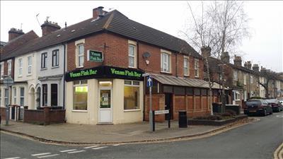
11 PARK ROAD WEST
BEDFORD, BEDFORD MK41 7SB
£259,995
Property details
Last sold
£105,000 May 2000
Local average
£375,000 (-30.7%)
Deprivation
Decile 2 (6,225 of 33,755)
Street crime
526 incidents within 1 mile (Apr 2026)
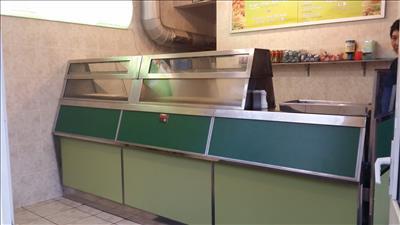
Description
The residential accommodation consists of a lounge, kitchen / diner, shower and WC on the ground floor whilst there are 3 double bedrooms and a family bathroom on the first floor.
The premises are currently let on 20 year lease dated December 2012 at an annual rent of £15,000. There are 5 yearly rent reviews and tenant only break clauses included.
Consideration is given to an owner occupier with the current tenants willing to negotiate the sale of the business.
Listed by
Commercial
Robinson & Hall LLP
Reference: 33177963
EPC Rating & Upgrade Cost
Fetching EPC data… Refresh this page in a moment.
Flood risk
Zone: 1
Risk: Low
Job (default Low)
Price history
| Event | Date | Price | % change |
|---|---|---|---|
| Sold | 24/05/2000 (26 years ago) | £105,000 | — |
Source: HM Land Registry Price Paid Data. Crown copyright.
Sold Comparables
Same street and nearby sales within 0.25 miles (last 5 years). Data from Land Registry Price Paid.
| Address | Price | Date | Type |
|---|---|---|---|
| 139 - 145 TAVISTOCK STREET, BEDFORD, MK40 2SB | £2,800,000 | 04/08/2022 | Other |
| 117 TAVISTOCK STREET, BEDFORD, MK40 2SB | £550,000 | 28/10/2021 | Other |
| 135 - 137 TAVISTOCK STREET, BEDFORD, MK40 2SB | £260,000 | 01/09/2021 | Other |
Area average: £1,203,333 (3 sales)
Capital growth trend
Land Registry outcode average: last 12 months vs 5y and 10y ago (from sold prices).
House Price Index (HM Land Registry — official index, not sold-price averages): Bedford. Series: All dwelling types. As of March 2026.
Rental Range
Estimated market rent for Bedford. Low = conservative, Realistic = average, Optimistic = best case.
Based on Local Authority from postcode lookup → Bedford.
LHA (30th percentile) floor for Bedford: Apr 2025 – Mar 2026
Location
Nearby
Nearest stations, universities and amenities (distance from property).
| Type | Name | Distance |
|---|---|---|
| Shop | Pasticceria | 0.0 miles |
| Shop | Michelle Hair | 0.0 miles |
| Bus stop | Warwick Avenue | 0.1 miles |
| Bus stop | Unknown | 0.2 miles |
| Train station | Bedford | 0.6 miles |
| Hospital | Bedford Health Village | 0.6 miles |
| Train station | Bedford St Johns | 1.0 miles |
| Hospital | Bedford Hospital South Wing | 1.0 miles |
| University | University of Bedfordshire Polhill Campus | 1.3 miles |
| University | Cranfield University | 8.3 miles |
Street-level crime
| Category | Count |
|---|---|
| Violence and sexual offences | 189 |
| Anti-social behaviour | 86 |
| Shoplifting | 63 |
| Public order | 34 |
| Criminal damage and arson | 28 |
| Other theft | 25 |
| Vehicle crime | 23 |
| Drugs | 21 |
| Burglary | 14 |
| Other crime | 13 |
| Robbery | 9 |
| Bicycle theft | 8 |
| Possession of weapons | 8 |
| Theft from the person | 5 |
| Total incidents | 526 |
Within 1 mile during Apr 2026. Source: data.police.uk (England & Wales).
Schools nearby
Nearest open schools with Ofsted ratings (England). Closed schools are not shown. Data from Get Information about Schools and Ofsted.
| Name | Type | Distance | Ofsted |
|---|---|---|---|
| Livingstone Primary School | Primary | 0.1 miles | Good — 18 May 2023 |
| Polam School | Other | 0.2 miles | — (No rating) |
| Edith Cavell Primary School | Primary | 0.4 miles | Good — 21 Oct 2014 |
| Priory Primary School | Primary | 0.4 miles | — (Inspected (no overall grade)) |
| Bedford Greenacre Independent School | Other | 0.4 miles | — (No rating) |
Rental Comparables
Residential lets from OpenRent and Rightmove for the area. Bedroom counts vary — use the Beds column to compare like-for-like lets. Student lets are excluded.
| Title | Rent | Beds | Distance | As seen on |
|---|---|---|---|---|
| Studio Flat, Foster Hill Road, MK40 | £800/mo | 1 | 0.19 miles | OpenRent |
| 3 Bed End Terrace, Gladstone St, MK41 | £1,400/mo | 3 | 0.2 miles | OpenRent |
| 3 Bed End Terrace, Hartington St, MK41 | £1,625/mo | 3 | 0.21 miles | OpenRent |
| Studio Flat, Bromham Road, MK40 | £750/mo | 1 | 0.27 miles | OpenRent |
Average rent: £1,144/mo (4 listings)
Rent-driven metrics
Based on OpenRent comparables.
- Rent ratio — Monthly rent ÷ purchase price (1% rule). 1%+ = strong, 0.8–1% = okay, <0.8% = weak for cashflow.
- Max investor price — Rent ÷ 0.8%; the price at which rent would be 0.8% of price (Stoke-style target).
- Target investor price — Rent ÷ 1%; the price at which rent would be 1% of price (strong cashflow band).
- Gross yield — Annual rent as % of purchase price (no costs).
- Cost-to-rent — Price ÷ annual rent (from OpenRent comparables). Under 14× = strong, 14–16× = acceptable, 17×+ = compressed.
- Cashflow — Rent minus mortgage, 10% maintenance, £25/mo compliance. Assumes 75% LTV, 3.95% APR (5yr fixed), 25yr term.
- ROI — Annual profit ÷ cash in (deposit + 4% purchase costs).