75 RAVENSDALE ROAD
LONDON, GREATER LONDON N16 6TH
£1,300 pcm
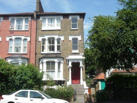
Photo 1
/ 1
Property details
Deprivation
Decile 1 (2,200 of 33,755)
Street crime
920 incidents within 1 mile (Apr 2026)
Key features
- Bright Living Room
- Open Plan Kitchen Overlooking Garden
- Large Double Bedroom
- Bathroom/W.C
- Gas Central Heating
- Direct Access to Garden
Additional details
- Garden
- Yes
Description
Listed by
London
Phillips Estates
Reference: 51161596
EPC Rating & Upgrade Cost
Fetching EPC data… Refresh this page in a moment.
Flood risk
Zone: 1
Risk: Low
Job (default Low)
Floorplans
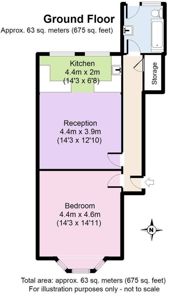
Floorplan 1
FENSA Certificates
This property has 1 FENSA certificate(s) on record, indicating window/door installations by FENSA-approved installers.
FENSA Certificate #11477589
Property Details
Street: 75 Ravensdale Road
Town: LONDON
Postcode: N16 6TH
Installation Details
Items: 3 windows
Certificate Issued: 07/03/2016
Work Completed: 04/09/2015
This certificate data was retrieved from FENSA's database
What is FENSA? FENSA (Fenestration Self-Assessment Scheme) is a government-authorised scheme that monitors building regulation compliance for replacement windows and doors. Certificates indicate that work was completed by FENSA-approved installers.
Company ownership
Registered legal owner is a company.
Company: 75 RAVENSDALE ROAD MANAGEMENT COMPANY LIMITED
Rental Range
Estimated market rent for Hackney. Low = conservative, Realistic = average, Optimistic = best case.
Based on Local Authority from postcode lookup → Hackney.
LHA (30th percentile) floor for Stevenage & North Herts: £773/mo (Apr 2025 – Mar 2026)
Location
Nearby
Nearest stations, universities and amenities (distance from property).
| Type | Name | Distance |
|---|---|---|
| Bus stop | Craven Park Road | 0.1 miles |
| Shop | Craven Park MOT Center | 0.2 miles |
| Shop | Boots | 0.3 miles |
| Train station | South Tottenham | 0.4 miles |
| Train station | Stamford Hill | 0.4 miles |
| Hospital | St Ann's Hospital | 1.0 miles |
| Hospital | Homerton University Hospital | 2.0 miles |
| University | University of Portsmouth Walthamstow Campus | 2.2 miles |
| University | The American University in London | 2.3 miles |
Street-level crime
| Category | Count |
|---|---|
| Anti-social behaviour | 218 |
| Violence and sexual offences | 189 |
| Shoplifting | 77 |
| Public order | 73 |
| Theft from the person | 71 |
| Vehicle crime | 65 |
| Criminal damage and arson | 58 |
| Other theft | 55 |
| Drugs | 35 |
| Burglary | 27 |
| Robbery | 25 |
| Bicycle theft | 11 |
| Other crime | 9 |
| Possession of weapons | 7 |
| Total incidents | 920 |
Within 1 mile during Apr 2026. Source: data.police.uk (England & Wales).
Schools nearby
Nearest open schools with Ofsted ratings (England). Closed schools are not shown. Data from Get Information about Schools and Ofsted.
| Name | Type | Distance | Ofsted |
|---|---|---|---|
| Bnos Zion of Bobov | Other | 0.1 miles | Requires improvement — 30 Sep 2022 |
| Bobov Primary Boys School | Other | 0.1 miles | Inadequate — 9 Sep 2024 |
| Springfield Community Primary School | Primary | 0.1 miles | Outstanding — 29 Nov 2023 |
| Bnei Zion Community School | Other | 0.1 miles | Inadequate — 19 Jan 2023 |
| Yesodey Hatorah Senior Girls School | Secondary | 0.2 miles | Good — 30 Jun 2024 |
Rental Comparables
Residential lets from OpenRent and Rightmove for the area (same bedroom count). Use to validate rent estimates. Student lets are excluded.
| Title | Rent | Beds | Distance | As seen on |
|---|---|---|---|---|
| Studio Flat, Ravensdale Road, N16 | £1,436/mo | 1 | 0.16 miles | OpenRent |
| Studio Flat, High Road, N15 | £1,250/mo | 1 | 0.25 miles | OpenRent |
| Studio Flat, High Road, N15 | £1,350/mo | 1 | 0.27 miles | OpenRent |
| Studio Flat, High Road, N15 | £1,350/mo | 1 | 0.27 miles | OpenRent |
Average rent: £1,347/mo (4 listings)