Car Park Lymedale Cross Industrial Estate
Newcastle Under Lyme ST5, ST5 9BT
£1 pcm
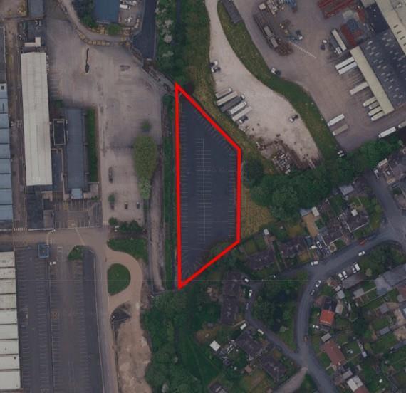
Photo 1
/ 1
Property details
Deprivation
Decile 4 (12,689 of 33,755)
Street crime
205 incidents within 1 mile (May 2026)
Description
Listed by
Birmingham - Commercial
Knight Frank
Reference: 174137102
Flood risk
Zone: 1
Risk: Low
Job (default Low)
Rental Range
Estimated market rent for Newcastle-under-Lyme. Low = conservative, Realistic = average, Optimistic = best case.
Based on Local Authority from postcode lookup → Newcastle-under-Lyme.
LHA (30th percentile) floor for Staffordshire North: Apr 2025 – Mar 2026
Location
Address
5 Lower Milehouse Lane
Nearby
Nearest stations, universities and amenities (distance from property).
| Type | Name | Distance |
|---|---|---|
| Bus stop | Meadow Avenue | 0.1 miles |
| Bus stop | Lower Milehouse Lane | 0.2 miles |
| Shop | Morrisons | 0.3 miles |
| Shop | Formula One Autocentres Newcastle-under-Lyme | 0.3 miles |
| Hospital | Bradwell Hospital | 0.9 miles |
| Train station | Silverdale | 1.1 miles |
| Train station | Apedale Road | 1.3 miles |
| Hospital | Hartshill Medical Centre | 1.7 miles |
| University | Keele University | 2.1 miles |
| University | University of Staffordshire Stoke Campus | 2.8 miles |
Street-level crime
| Category | Count |
|---|---|
| Violence and sexual offences | 81 |
| Anti-social behaviour | 43 |
| Shoplifting | 19 |
| Public order | 14 |
| Criminal damage and arson | 13 |
| Other theft | 13 |
| Vehicle crime | 10 |
| Bicycle theft | 3 |
| Burglary | 3 |
| Drugs | 2 |
| Robbery | 2 |
| Other crime | 1 |
| Possession of weapons | 1 |
| Total incidents | 205 |
Within 1 mile during May 2026. Source: data.police.uk (England & Wales).
Schools nearby
Nearest open schools with Ofsted ratings (England). Closed schools are not shown. Data from Get Information about Schools and Ofsted.
| Name | Type | Distance | Ofsted |
|---|---|---|---|
| Merryfields School | Other | 0.6 miles | Good — 30 Apr 2014 |
| Hempstalls Primary School | Primary | 0.6 miles | — (Inspected (no overall grade)) |
| Knutton St Marys CofE Academy | Primary | 0.7 miles | Good — 4 Jun 2019 |
| Churchfields Primary School | Primary | 0.7 miles | Outstanding — 15 Sep 2015 |
| St John Fisher Catholic College | Secondary | 0.7 miles | Requires improvement — 5 Mar 2024 |
Rental Comparables
Residential lets from OpenRent and Rightmove for the area. Bedroom counts vary — use the Beds column to compare like-for-like lets. Student lets are excluded.
Average rent: £1,067/mo (127 listings)