Apartment 427
TOBACCO WAREHOUSE, 21A, REGENT ROAD, LIVERPOOL, MERSEYSIDE L3 0BL


Property details
Floor area
204 m²
Council tax band
TBC
Deprivation
Decile 2 (5,337 of 33,755)
Street crime
437 incidents within 1 mile (Apr 2026)
Additional details
- Parking
- Yes
Description
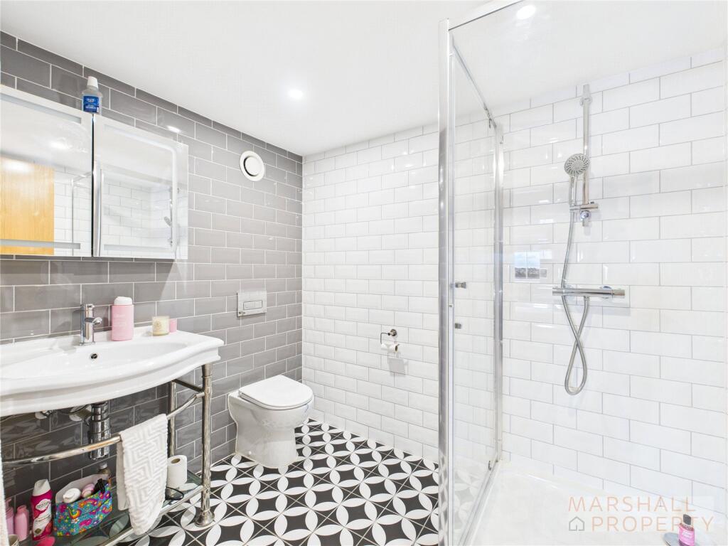
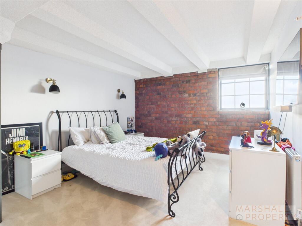
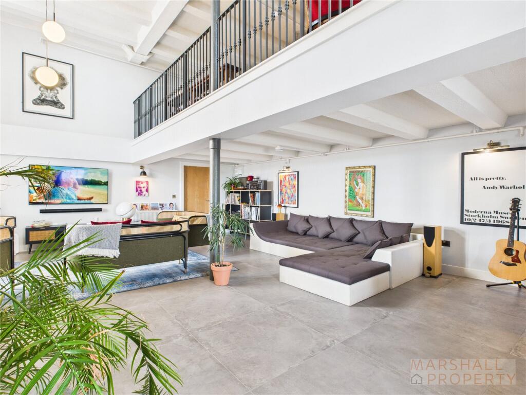
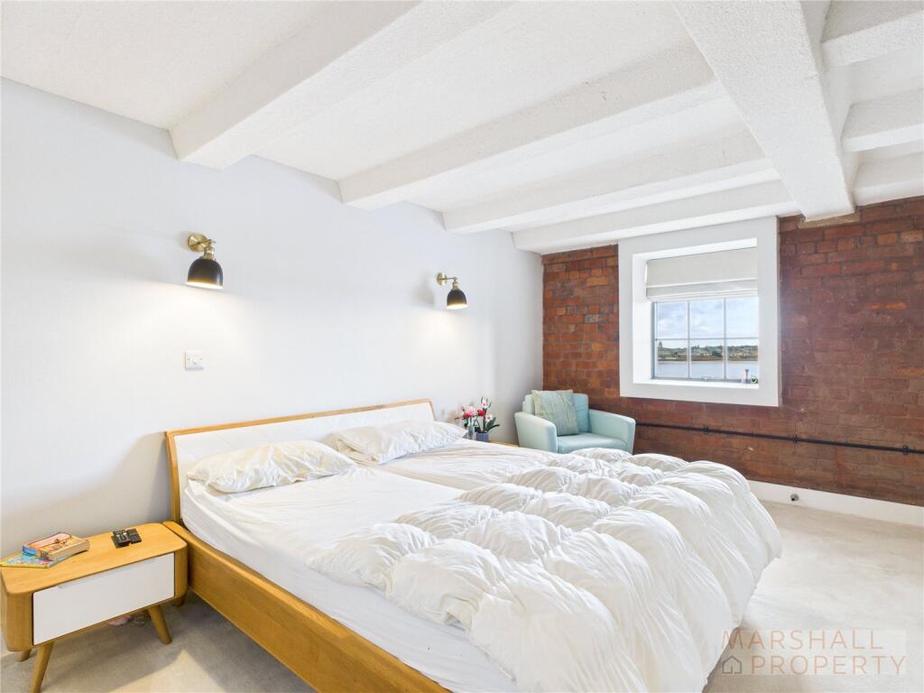
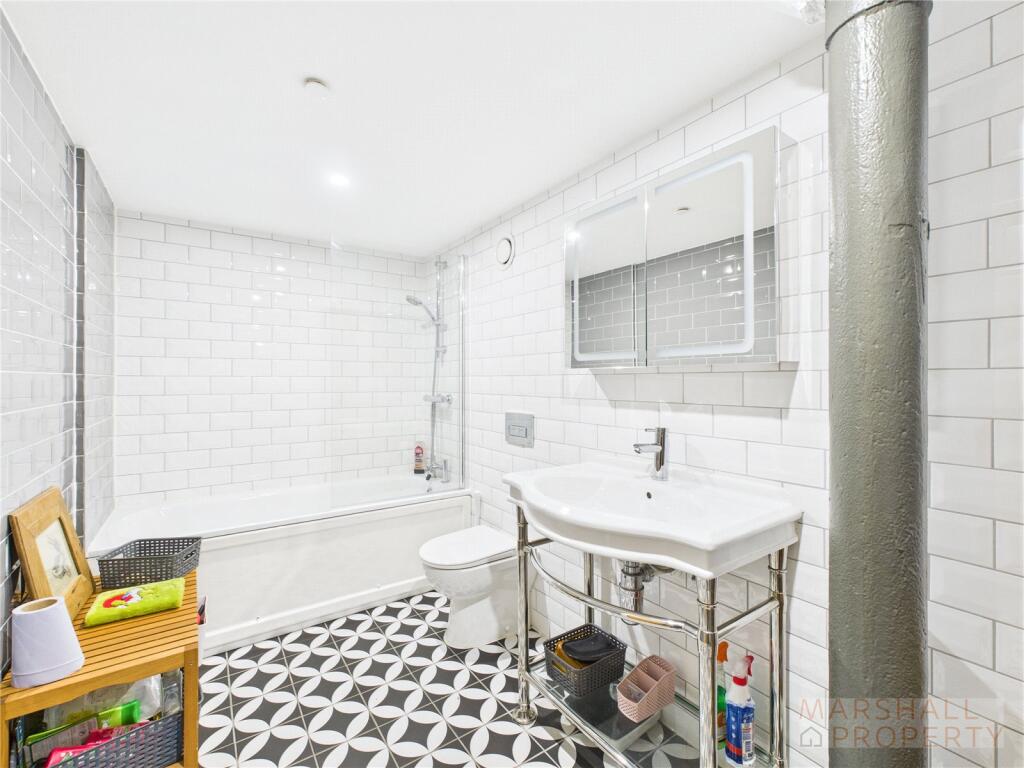
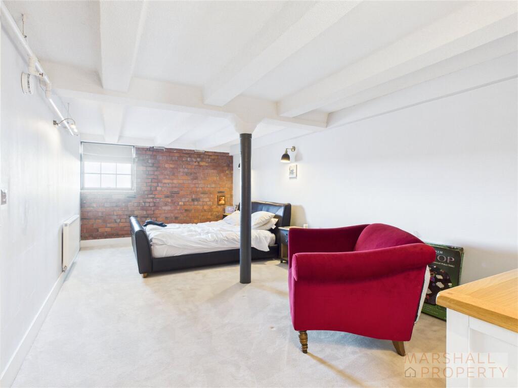
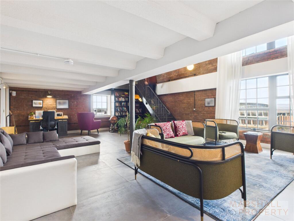
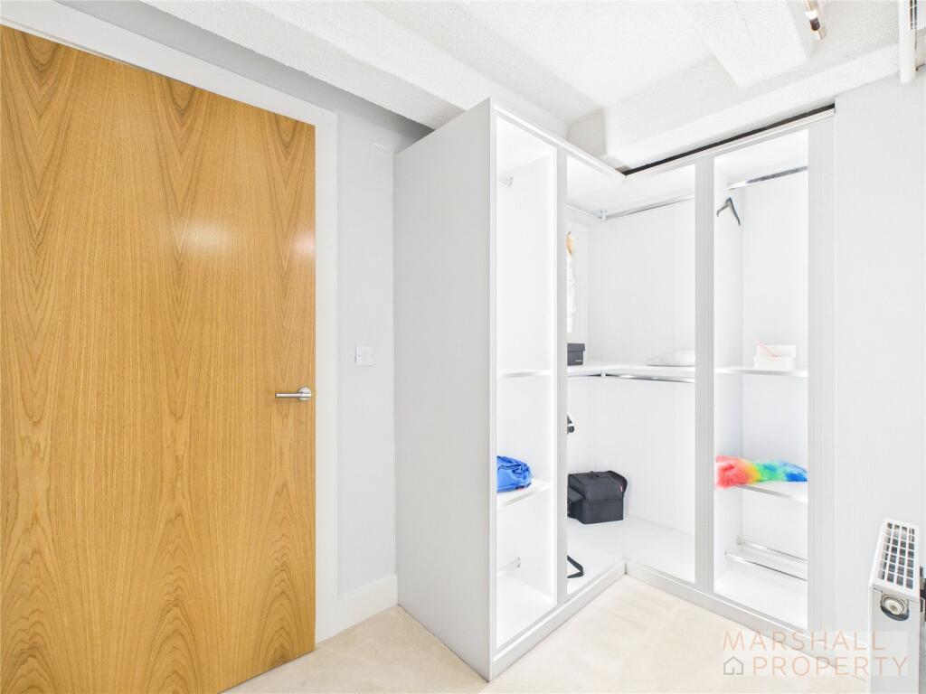
The property features expansive double-height living areas with mezzanine floors, exposed brickwork, concrete beams, and industrial-style pillars. The kitchen is fitted with integrated European appliances, while the living spaces are finished with brushed concrete tiles and the bedrooms with silk carpets. Each bedroom includes a walk-in wardrobe and luxury en-suite.
Residents benefit from SONOS surround sound throughout, a Virgin Broadband and Sky TV package, and two allocated underground parking spaces. A 5-star concierge service and on-site management team provide additional convenience and security.
Positioned on a corner plot, the apartment enjoys dual-aspect views over the River Mersey, the Wirral Peninsula, and the north of the city, including the newly opened Everton Stadium. Located within a private marina alongside the Titanic Hotel, and just a short walk from Liverpool city centre, the area is part of the exciting North Docks regeneration, including the Ten Streets and Liverpool Waters developments.
Listed by
Liverpool
Marshallets Limited
Reference: 167101517
EPC ratings on this postcode
We don't have a matched EPC for this property yet. Below are efficiency scores and details for other addresses on this postcode.
| Address | Current | Potential | Floor area | Age band | Type |
|---|---|---|---|---|---|
| Apartment 401, No. 21A Regent Road, Liverpool | 85 | 85 | 198 m² | — | Flat |
| Apartment 402, No. 21A Regent Road, Liverpool | 83 | 83 | 181 m² | — | Flat |
| Apartment 403, No. 21A Regent Road, Liverpool | 83 | 83 | 116 m² | — | Flat |
| Apartment 404, No. 21A Regent Road, Liverpool | 83 | 83 | 126 m² | — | Flat |
| Apartment 405, No. 21A Regent Road, Liverpool | 84 | 84 | 117 m² | — | Flat |
| Apartment 406, No. 21A Regent Road, Liverpool | 83 | 83 | 128 m² | — | Flat |
| Apartment 407, No. 21A Regent Road, Liverpool | 82 | 82 | 116 m² | — | Flat |
| Apartment 408, No. 21A Regent Road, Liverpool | 83 | 83 | 127 m² | — | Flat |
| Apartment 409, No. 21A Regent Road, Liverpool | 85 | 85 | 206 m² | — | Flat |
| Apartment 410, No. 21A Regent Road, Liverpool | 82 | 82 | 146 m² | — | Flat |
| Apartment 411, No. 21A Regent Road, Liverpool | 84 | 84 | 177 m² | — | Flat |
| Apartment 412, No. 21A Regent Road, Liverpool | 83 | 83 | 137 m² | — | Flat |
| Apartment 413, No. 21A Regent Road, Liverpool | 84 | 84 | 114 m² | — | Flat |
| Apartment 414, No. 21A Regent Road, Liverpool | 83 | 83 | 127 m² | — | Flat |
| Apartment 415, No. 21A Regent Road, Liverpool | 83 | 83 | 112 m² | — | Flat |
Flood risk
Zone: 1
Risk: Low
Job (default Low)
Rental Range
Estimated market rent for Liverpool. Low = conservative, Realistic = average, Optimistic = best case.
Based on Local Authority from postcode lookup → Liverpool.
LHA (30th percentile) floor for Greater Liverpool: £648/mo (Apr 2025 – Mar 2026)
Location
Address
Regent Road
Nearby
Nearest stations, universities and amenities (distance from property).
| Type | Name | Distance |
|---|---|---|
| Bus stop | REGENT RAOD/NR CLARENCE DOCKS | 0.1 miles |
| Bus stop | GREAT HOWARD STREET/STANLEY DOCK | 0.1 miles |
| Shop | W H Lung | 0.3 miles |
| Shop | Beers Timber & Building Supplies Limited | 0.4 miles |
| Train station | Sandhills | 0.7 miles |
| Train station | Moorfields | 1.0 miles |
| Hospital | Greenbank Drive Surgery | 3.6 miles |
| Hospital | Rathbone Hospital | 3.6 miles |
| University | Liverpool Hope University | 4.9 miles |
| University | Edge Hill University | 10.9 miles |
Street-level crime
| Category | Count |
|---|---|
| Violence and sexual offences | 106 |
| Public order | 65 |
| Anti-social behaviour | 60 |
| Drugs | 54 |
| Shoplifting | 42 |
| Criminal damage and arson | 36 |
| Vehicle crime | 24 |
| Other theft | 18 |
| Other crime | 17 |
| Burglary | 10 |
| Possession of weapons | 2 |
| Bicycle theft | 1 |
| Robbery | 1 |
| Theft from the person | 1 |
| Total incidents | 437 |
Within 1 mile during Apr 2026. Source: data.police.uk (England & Wales).
Schools nearby
Nearest open schools with Ofsted ratings (England). Closed schools are not shown. Data from Get Information about Schools and Ofsted.
| Name | Type | Distance | Ofsted |
|---|---|---|---|
| The Trinity Catholic Academy | Primary | 0.6 miles | Inadequate — 13 May 2019 |
| Holy Cross Catholic Primary School | Primary | 0.9 miles | Good — 17 Apr 2018 |
| Notre Dame Catholic Academy | Secondary | 0.9 miles | Requires improvement — 17 Jul 2022 |
| Faith Primary Academy | Primary | 1.0 miles | Good — 14 Jan 2019 |
| Millstead School | Other | 1.0 miles | Outstanding — 28 Mar 2013 |
Rental Comparables
Residential lets from OpenRent and Rightmove for the area (same bedroom count). Use to validate rent estimates. Student lets are excluded.
| Title | Rent | Beds | Distance | As seen on |
|---|---|---|---|---|
| 3 Bed Flat, Stanley Wharf, L5 | £1,215/mo | 3 | 0.16 miles | OpenRent |
| 3 Bed Semi-Detached House, St Alphonsus St, L5 | £2,645/mo | 3 | 0.83 miles | OpenRent |
Average rent: £1,930/mo (2 listings)
Enter House Number
Enter the house number to help us retrieve more accurate pricing history and property data.
Please log in to submit or correct the house number for this listing.
Log in to continue