Idle Road
Five Lane Ends, Bradford, BD2, BD2 2AW
£139,995


Property details
Last sold
£134,000
Local average
£141,505 (-1.1%)
Deprivation
Decile 4 (12,912 of 33,755)
Street crime
401 incidents within 1 mile (Apr 2026)
Key features
- Reduced
Description
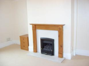
LOUNGE: 16' 1" x 12' 6''
Lounge with bay window. Solid fuel gas fire set on tiled hearth with Adams style surround in oak. Excellent décor finished in laminate flooring. Coved ceiling and decorative central ceiling rose. T.V. and telephone point. Curtains included in purchase price.
KITCHEN: 11'4" x 6'4"
The kitchen features a range of base and wall units in white with pine trim, display units and contrasting roll edge worktops. Stainless steel sink with mixer taps. Integrated electric oven, gas hob with extractor fan. Finished in laminate flooring. Plumbed for washing machine and dishwasher.
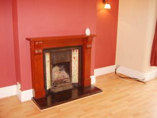
DINING ROOM: 14' 1" x 12'1"
Separate spacious dining room with living flame gas fire set on marble hearth with Adams style surround in Pine. Coved ceiling and picture rail. T.V. and telephone point. Carpets and curtains included in the purchase price.
BEDROOM 1: 14'10" x 12'0"
Spacious master bedroom.
BEDROOM 2: 13' 8" x 11'7"
Second spacious double bedroom.
BEDROOM 3: 8'11" x 6'11"
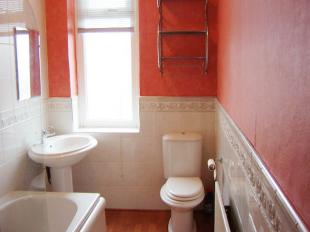
BATHROOM: 10'6" x 5'5"
The bathroom consists of a three-piece suite in white with chrome fittings and gas shower. Finished in laminate flooring.
ATTIC BEDROOM 4: 15'0" x 14' 9"
Large attic bedroom with walk in cloakroom, laminate wood floor and sky light window.
DIRECTIONS
From our Bolton Junction office head along Idle Road and the property is situated on the left hand side
Listed by
Eccleshill
WW Estates
Reference: 8342822
EPC ratings on this postcode
We don't have a matched EPC for this property yet. Below are efficiency scores and details for other addresses on this postcode.
| Address | Current | Potential | Floor area | Age band | Type |
|---|---|---|---|---|---|
| 362 Idle Road, Five Lane Ends, BRADFORD | 57 | 83 | 115 m² | England and Wales: 1930-1949 | Detached |
| 366, Idle Road, Five Lane Ends, BRADFORD | 55 | 79 | 140 m² | England and Wales: 1900-1929 | Detached |
| 380, Idle Road, Five Lane Ends, BRADFORD | 59 | 85 | 108 m² | England and Wales: 1950-1966 | Detached |
| 382, Idle Road, Five Lane Ends, BRADFORD | 52 | 78 | 98 m² | England and Wales: 1950-1966 | Detached |
| 394, Idle Road, Five Lane Ends, BRADFORD | 43 | 78 | 160 m² | England and Wales: 1930-1949 | Detached |
| 394, Idle Road, Five Lane Ends, BRADFORD | 54 | 75 | 168 m² | England and Wales: 1900-1929 | Detached |
| 394, Idle Road, Five Lane Ends, BRADFORD | 57 | 80 | 169 m² | England and Wales: 1930-1949 | Detached |
| 394, Idle Road, Five Lane Ends, BRADFORD | 37 | 68 | 161 m² | England and Wales: 1930-1949 | Detached |
| 394, Idle Road, Five Lane Ends, BRADFORD | 58 | 81 | 159 m² | England and Wales: 1900-1929 | Detached |
| 396 Idle Road, Five Lane Ends, BRADFORD | 67 | 82 | 123 m² | England and Wales: 1900-1929 | Detached |
| 398, Idle Road, Five Lane Ends, BRADFORD | 32 | 74 | 124 m² | England and Wales: 1900-1929 | Detached |
| 400 Idle Road, Five Lane Ends, BRADFORD | 75 | 81 | 177 m² | England and Wales: 1930-1949 | Detached |
| 400, Idle Road, Five Lane Ends, BRADFORD | 43 | 81 | 120 m² | England and Wales: 1900-1929 | Detached |
| 402, Idle Road, Five Lane Ends, BRADFORD | 51 | 79 | 127 m² | England and Wales: 1900-1929 | Detached |
| 404, Idle Road, Five Lane Ends, BRADFORD | 52 | 76 | 213 m² | England and Wales: 1930-1949 | Detached |
Flood risk
Zone: 1
Risk: Low
Job (default Low)
Price history
No sales history found for this property in Land Registry Price Paid data.
Sold Comparables
Same street and nearby sales within 0.25 miles (last 5 years). Data from Land Registry Price Paid.
| Address | Price | Date | Type |
|---|---|---|---|
| 306 IDLE ROAD, BRADFORD, WEST YORKSHIRE, BD2 2AL | £200,000 | 19/12/2025 | Terraced |
| 330 IDLE ROAD, BRADFORD, WEST YORKSHIRE, BD2 2AL | £145,000 | 19/11/2025 | Terraced |
| 503 IDLE ROAD, BRADFORD, WEST YORKSHIRE, BD2 2AY | £185,000 | 24/11/2023 | Terraced |
| 420 IDLE ROAD, BRADFORD, WEST YORKSHIRE, BD2 2AR | £190,000 | 20/10/2023 | Terraced |
| 310 IDLE ROAD, BRADFORD, WEST YORKSHIRE, BD2 2AL | £146,000 | 16/12/2022 | Terraced |
| 312 IDLE ROAD, BRADFORD, WEST YORKSHIRE, BD2 2AL | £130,000 | 14/06/2022 | Terraced |
| 77 NORMAN AVENUE, BRADFORD, WEST YORKSHIRE, BD2 2ND | £156,000 | 22/04/2022 | Terraced |
| 1125A BOLTON ROAD, BRADFORD, WEST YORKSHIRE, BD2 4SP | £155,000 | 18/03/2022 | Terraced |
| 5 GATEHOUSE MEWS, BRADFORD, WEST YORKSHIRE, BD2 2BD | £160,000 | 11/02/2022 | Terraced |
| 9 MYERS LANE, BRADFORD, WEST YORKSHIRE, BD2 4EP | £122,000 | 11/01/2022 | Terraced |
| 424 IDLE ROAD, BRADFORD, WEST YORKSHIRE, BD2 2AR | £158,500 | 07/01/2022 | Terraced |
| 1119 BOLTON ROAD, BRADFORD, WEST YORKSHIRE, BD2 4SP | £125,000 | 23/11/2021 | Terraced |
| 503A IDLE ROAD, BRADFORD, WEST YORKSHIRE, BD2 2AY | £159,950 | 17/09/2021 | Terraced |
| 503A IDLE ROAD, BRADFORD, WEST YORKSHIRE, BD2 2AY | £155,000 | 10/09/2021 | Terraced |
| 2 IVY PLACE, BRADFORD, WEST YORKSHIRE, BD2 2BA | £280,000 | 23/07/2021 | Terraced |
Area average: £164,497 (15 sales)
Capital growth trend
Land Registry outcode average: last 12 months vs 5y and 10y ago (from sold prices).
House Price Index (HM Land Registry — official index, not sold-price averages): Bradford. Series: Terraced. As of March 2026.
Rental Range
Estimated market rent for Bradford. Low = conservative, Realistic = average, Optimistic = best case.
Based on Local Authority from postcode lookup → Bradford.
LHA (30th percentile) floor for Bradford & South Dales: £748/mo (Apr 2025 – Mar 2026)
Location
Nearby
Nearest stations, universities and amenities (distance from property).
| Type | Name | Distance |
|---|---|---|
| Bus stop | Idle Road High House Road | 0.0 miles |
| Shop | Nautical Vapes | 0.2 miles |
| Shop | Khayams | 0.2 miles |
| Hospital | Eccleshill NHS Treatment Centre | 1.0 miles |
| Train station | Frizinghall | 1.4 miles |
| Train station | Bradford Forster Square | 1.7 miles |
| Hospital | Moorlands View | 2.9 miles |
| University | Leeds Trinity University | 4.2 miles |
| University | Kirkstall Brewery Residences | 5.2 miles |
Street-level crime
| Category | Count |
|---|---|
| Violence and sexual offences | 172 |
| Anti-social behaviour | 74 |
| Criminal damage and arson | 37 |
| Public order | 28 |
| Drugs | 20 |
| Shoplifting | 18 |
| Other theft | 14 |
| Burglary | 13 |
| Vehicle crime | 12 |
| Other crime | 8 |
| Possession of weapons | 3 |
| Robbery | 2 |
| Total incidents | 401 |
Within 1 mile during Apr 2026. Source: data.police.uk (England & Wales).
Schools nearby
Nearest open schools with Ofsted ratings (England). Closed schools are not shown. Data from Get Information about Schools and Ofsted.
| Name | Type | Distance | Ofsted |
|---|---|---|---|
| St Francis Catholic Primary School, A Voluntary Academy | Primary | 0.2 miles | Good — 7 Feb 2013 |
| Swain House Primary School | Primary | 0.2 miles | Good — 1 Nov 2011 |
| Hanson Academy | Secondary | 0.3 miles | Inadequate — 2 Jul 2020 |
| Grove House Primary School | Primary | 0.3 miles | Good — 21 Nov 2023 |
| Wellington Primary School | Primary | 0.6 miles | Good — 24 Dec 2013 |
Rental Comparables
Rental comparables are temporarily unavailable while listing-site fetches are paused. Try again later.
Rent-driven metrics
Based on Area rent estimate.
- Rent ratio — Monthly rent ÷ purchase price (1% rule). 1%+ = strong, 0.8–1% = okay, <0.8% = weak for cashflow.
- Max investor price — Rent ÷ 0.8%; the price at which rent would be 0.8% of price (Stoke-style target).
- Target investor price — Rent ÷ 1%; the price at which rent would be 1% of price (strong cashflow band).
- Gross yield — Annual rent as % of purchase price (no costs).
Enter House Number
Enter the house number to help us retrieve more accurate pricing history and property data.
Please log in to submit or correct the house number for this listing.
Log in to continue