15 DERRY STREET
STOKE-ON-TRENT, STOKE-ON-TRENT ST4 3BD
£400 pcm
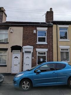
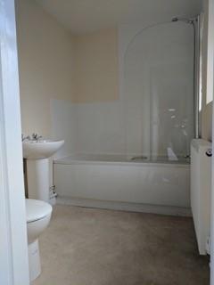
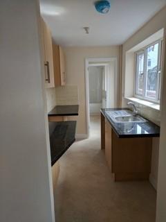
Photo 1 Photo 2 Photo 3
/ 3
Property details
Floor area
59 m²
EPC rating
D
Deprivation
Decile 2 (4,290 of 33,755)
Street crime
295 incidents within 1 mile (Apr 2026)
Additional details
- Heating
- Double glazing, Gas central
- Parking
- On street
- Garden
- Rear garden
Description
Comprising two double bedrooms.
Two living rooms.
Newly fitted kitchen with plentiful storage space and breakfast bar.
Newly fitted bathroom with bath and over bath shower.
paved rear courtyard with access on to vehicle accessible entry.
Works also included all new double glazing and full comb-boiler gas heating system
Listed by
Brierley Hill
PTN Estates
Reference: 66670331
EPC Rating & Upgrade Cost
Current rating: D
Potential rating: C
Inspection date: 06/07/2022
Expiry date: 05/07/2032
Current heating cost: £674/year
Potential heating cost: £526/year
Est. upgrade cost to C: £23,925
Recommendations
- 50 mm internal or external wall insulation (£4,000 - £14,000)
- Floor insulation (solid floor) (£4,000 - £6,000)
- Low energy lighting for all fixed outlets (£25)
- Upgrade heating controls (£350 - £450)
- Solar water heating (£4,000 - £6,000)
- Solar photovoltaic panels, 2.5 kWp (£3,500 - £5,500)
Flood risk
Zone: 1
Risk: Low
Job (default Low)
Rental Range
Estimated market rent for Stoke-on-Trent. Low = conservative, Realistic = average, Optimistic = best case.
Based on Local Authority from postcode lookup → Stoke-on-Trent.
LHA (30th percentile) floor for Staffordshire North: £479/mo (Apr 2025 – Mar 2026)
Location
Nearby
Nearest stations, universities and amenities (distance from property).
| Type | Name | Distance |
|---|---|---|
| Bus stop | Unknown | 0.1 miles |
| Shop | Bargain Booze | 0.3 miles |
| Shop | Unknown | 0.3 miles |
| Train station | Longton | 1.0 miles |
| Train station | Stoke-on-Trent | 1.4 miles |
| Hospital | Royal Stoke University Hospital | 2.3 miles |
| Hospital | North Staffordshire Nuffield Hospital | 2.6 miles |
| University | Keele University | 4.6 miles |
| University | Buxton & Leek College | 9.9 miles |
Street-level crime
| Category | Count |
|---|---|
| Violence and sexual offences | 106 |
| Anti-social behaviour | 49 |
| Shoplifting | 28 |
| Vehicle crime | 28 |
| Criminal damage and arson | 18 |
| Public order | 17 |
| Other theft | 14 |
| Drugs | 9 |
| Other crime | 8 |
| Burglary | 6 |
| Robbery | 5 |
| Bicycle theft | 3 |
| Possession of weapons | 3 |
| Theft from the person | 1 |
| Total incidents | 295 |
Within 1 mile during Apr 2026. Source: data.police.uk (England & Wales).
Schools nearby
Nearest open schools with Ofsted ratings (England). Closed schools are not shown. Data from Get Information about Schools and Ofsted.
| Name | Type | Distance | Ofsted |
|---|---|---|---|
| Glebedale School | Other | 0.1 miles | Good — 25 Jan 2023 |
| Heron Cross Primary School | Primary | 0.1 miles | Good — 25 Jan 2022 |
| Our Lady's Catholic Academy | Primary | 0.6 miles | Good — 21 May 2015 |
| Co-op Academy Glebe | Primary | 0.6 miles | Outstanding — 16 Jul 2024 |
| St Thomas More Catholic Academy | Secondary | 0.7 miles | Good — 8 Jun 2017 |
Rental Comparables
Residential lets from OpenRent and Rightmove for the area (same bedroom count). Use to validate rent estimates. Student lets are excluded.
Average rent: £779/mo (57 listings)