FLAT 5
31 RADSTOCK ROAD, SOUTHAMPTON, SOUTHAMPTON, SOUTHAMPTON SO19 2HN
£97,500
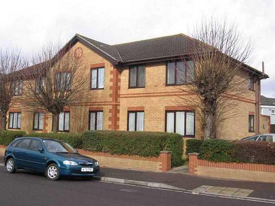
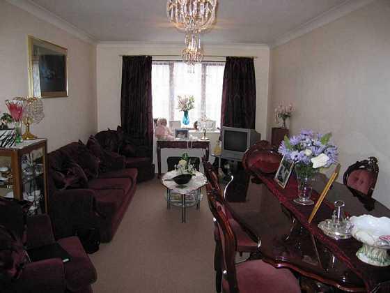
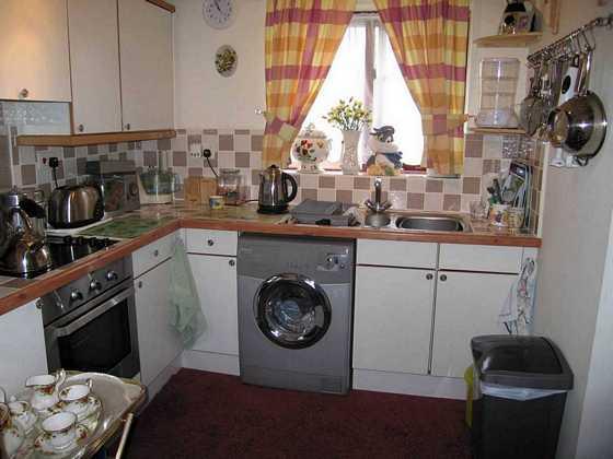
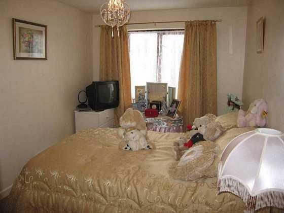
Photo 1 Photo 2 Photo 3 Photo 4
/ 4
Property details
Floor area
47 m²
EPC rating
E
Year built
England and Wales: 1983-1990
Last sold
£116,000 May 2008
Price per m²
£2,074/m²
Local average
£157,044 (-37.9%)
Deprivation
Decile 2 (5,059 of 33,755)
Street crime
387 incidents within 1 mile (Apr 2026)
Additional details
- Parking
- Yes
- Garden
- Yes
Description
5.42m x 3.12m
17' 9'' x 10' 3''Fitted Kitchen
2.38m x 2.30m
7' 10'' x 7' 7''Bedroom
2.62m x 3.56m to wardrobe
8' 7'' x 11' 8'' to wardrobeBathroomCommunal GardenCommunal Parking
Listed by
Bitterne
Halifax Estate Agents
Reference: 24909590
EPC Rating & Upgrade Cost
Current rating: E
Potential rating: C
Inspection date: 05/04/2019
Expiry date: 04/04/2029
Current heating cost: £499/year
Potential heating cost: £255/year
Est. upgrade cost to C: £1,000
Recommendations
- High heat retention storage heaters and dual immersion cylinder (£800 - £1,200)
Flood risk
Zone: 1
Risk: Low
Job (default Low)
Floorplans
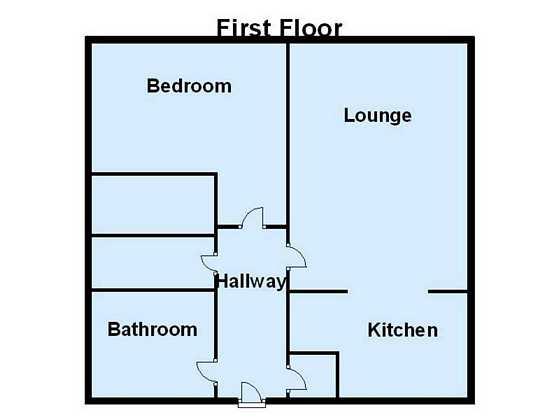
Floorplan 1
Price history
231% since 1997
| Event | Date | Price | % change |
|---|---|---|---|
| Sold | 23/05/2008 (18 years ago) | £116,000 | +231.4% |
| Sold | 28/02/1997 (29 years ago) | £35,000 | — |
Source: HM Land Registry Price Paid Data. Crown copyright.
Sold Comparables
Same street and nearby sales within 0.25 miles (last 5 years). Data from Land Registry Price Paid.
| Address | Price | Date | Type |
|---|---|---|---|
| ROBERE HOUSE FLAT 29 RADSTOCK ROAD, SOUTHAMPTON, SO19 2QW | £115,000 | 25/11/2025 | Flat |
| ROBERE HOUSE FLAT 22 RADSTOCK ROAD, SOUTHAMPTON, SO19 2QW | £110,000 | 07/01/2025 | Flat |
| ROBERE HOUSE FLAT 19 RADSTOCK ROAD, SOUTHAMPTON, SO19 2QW | £95,000 | 11/07/2023 | Flat |
| 3 RADSTOCK ROAD, SOUTHAMPTON, SO19 2HN | £175,000 | 23/06/2023 | Flat |
| 22A RADSTOCK ROAD, SOUTHAMPTON, SO19 2HP | £154,500 | 09/12/2022 | Flat |
| 22 RADSTOCK ROAD, SOUTHAMPTON, SO19 2HP | £177,000 | 09/12/2022 | Flat |
| ROBERE HOUSE FLAT 26 RADSTOCK ROAD, SOUTHAMPTON, SO19 2QW | £110,000 | 20/12/2021 | Flat |
Area average: £133,786 (7 sales)
Capital growth trend
Land Registry outcode average: last 12 months vs 5y and 10y ago (from sold prices).
House Price Index (HM Land Registry — official index, not sold-price averages): Southampton. Series: Flats and maisonettes. As of March 2026.
Rental Range
Estimated market rent for Southampton. Low = conservative, Realistic = average, Optimistic = best case.
Based on Local Authority from postcode lookup → Southampton.
LHA (30th percentile) floor for Southampton: £698/mo (Apr 2025 – Mar 2026)
Location
Nearby
Nearest stations, universities and amenities (distance from property).
| Type | Name | Distance |
|---|---|---|
| Bus stop | The Drummond | 0.0 miles |
| Shop | Intruder Alert Systems Ltd | 0.1 miles |
| Shop | Bill's Bait & Tackle | 0.1 miles |
| Train station | Woolston | 0.1 miles |
| Train station | Sholing | 0.6 miles |
| University | Warsash Maritime Acadmeny | 0.8 miles |
| University | Waterfront Campus | 1.0 miles |
| Hospital | Royal South Hants Urgent Treatment Centre | 1.3 miles |
| Hospital | Royal South Hants Hospital | 1.3 miles |
Street-level crime
| Category | Count |
|---|---|
| Violence and sexual offences | 150 |
| Shoplifting | 69 |
| Criminal damage and arson | 35 |
| Anti-social behaviour | 29 |
| Other theft | 26 |
| Public order | 20 |
| Vehicle crime | 13 |
| Drugs | 12 |
| Other crime | 11 |
| Burglary | 10 |
| Possession of weapons | 5 |
| Bicycle theft | 4 |
| Robbery | 2 |
| Theft from the person | 1 |
| Total incidents | 387 |
Within 1 mile during Apr 2026. Source: data.police.uk (England & Wales).
Schools nearby
Nearest open schools with Ofsted ratings (England). Closed schools are not shown. Data from Get Information about Schools and Ofsted.
| Name | Type | Distance | Ofsted |
|---|---|---|---|
| St Patrick's Catholic Primary School | Primary | 0.2 miles | Good — 20 Jul 2015 |
| Ludlow Infant Academy | Primary | 0.2 miles | Good — 7 Nov 2018 |
| Ludlow Junior School | Primary | 0.3 miles | Good — 1 Feb 2012 |
| Woolston Infant School | Primary | 0.3 miles | Good — 18 Dec 2014 |
| Oasis Academy Sholing | Secondary | 0.8 miles | Requires improvement — 1 Dec 2022 |
Rental Comparables
Residential lets from OpenRent and Rightmove for the area (same bedroom count). Use to validate rent estimates. Student lets are excluded.
| Title | Rent | Beds | Distance | As seen on |
|---|---|---|---|---|
| 1 Bed Flat, Bridge Terrace, SO14 | £1,245/mo | 1 | 0.67 miles | OpenRent |
| 1 Bed Flat, Albert Road South, SO14 | £750/mo | 1 | 0.69 miles | OpenRent |
| 1 Bed Flat, Albert Road South, SO14 | £825/mo | 1 | 0.69 miles | OpenRent |
| 1 Bed Flat, Atlantic Mansions, SO14 | £900/mo | 1 | 0.72 miles | OpenRent |
| 1 Bed Flat, Atlantic Mansions, SO14 | £2,400/mo | 1 | 0.73 miles | OpenRent |
Average rent: £1,224/mo (5 listings)
Rent-driven metrics
Based on OpenRent comparables.
- Rent ratio — Monthly rent ÷ purchase price (1% rule). 1%+ = strong, 0.8–1% = okay, <0.8% = weak for cashflow.
- Max investor price — Rent ÷ 0.8%; the price at which rent would be 0.8% of price (Stoke-style target).
- Target investor price — Rent ÷ 1%; the price at which rent would be 1% of price (strong cashflow band).
- Gross yield — Annual rent as % of purchase price (no costs).
- Cost-to-rent — Price ÷ annual rent (from OpenRent comparables). Under 14× = strong, 14–16× = acceptable, 17×+ = compressed.
- Cashflow — Rent minus mortgage, 10% maintenance, £25/mo compliance. Assumes 75% LTV, 3.95% APR (5yr fixed), 25yr term.
- ROI — Annual profit ÷ cash in (deposit + 4% purchase costs).