Church Street
Stone, ST15, ST15 8BU
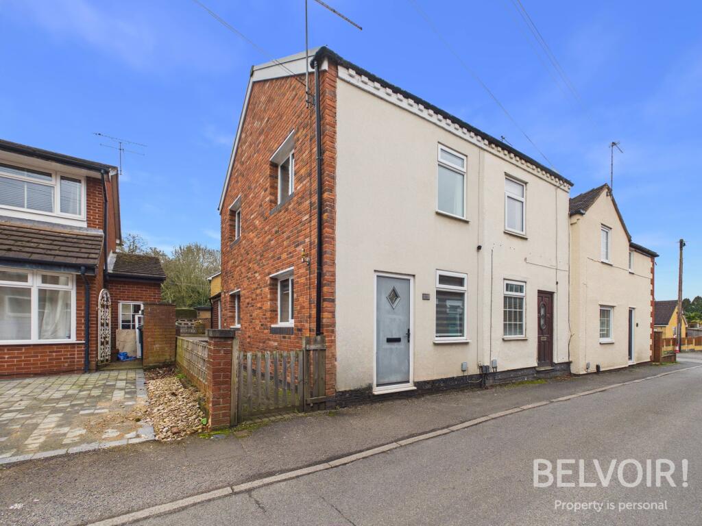
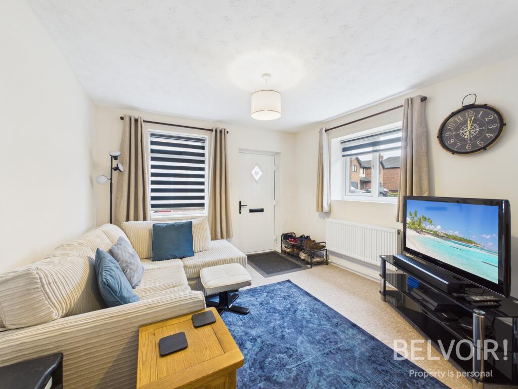
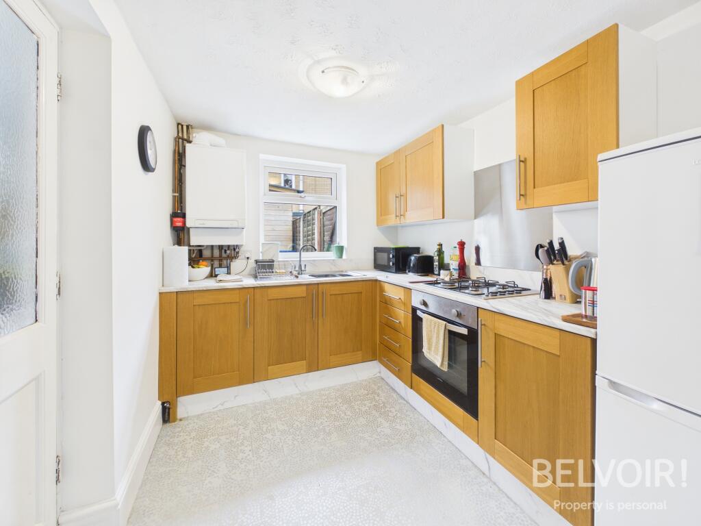
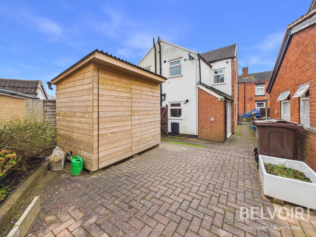
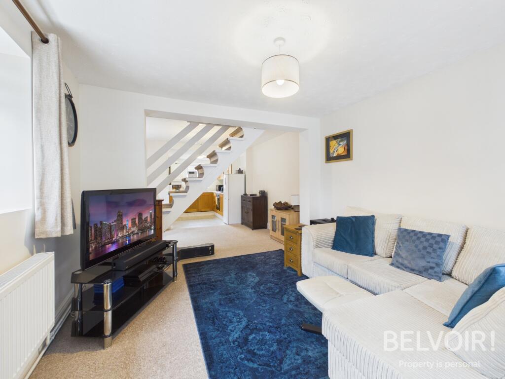
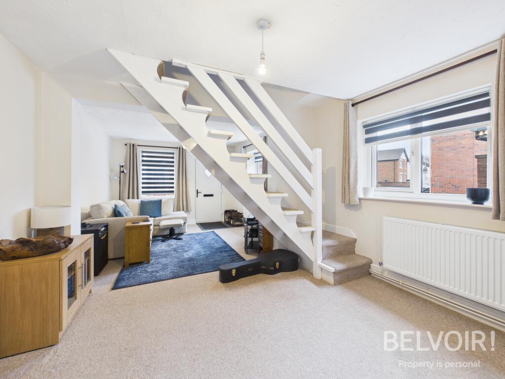
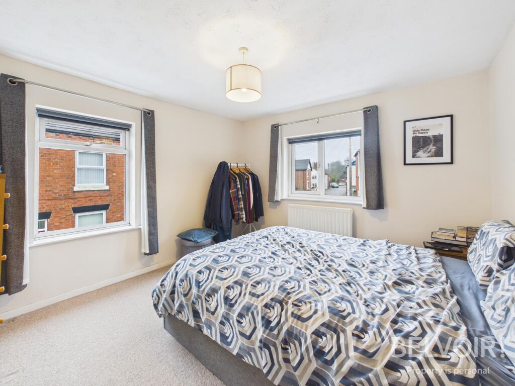
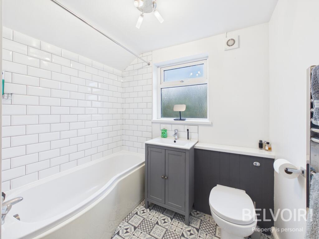
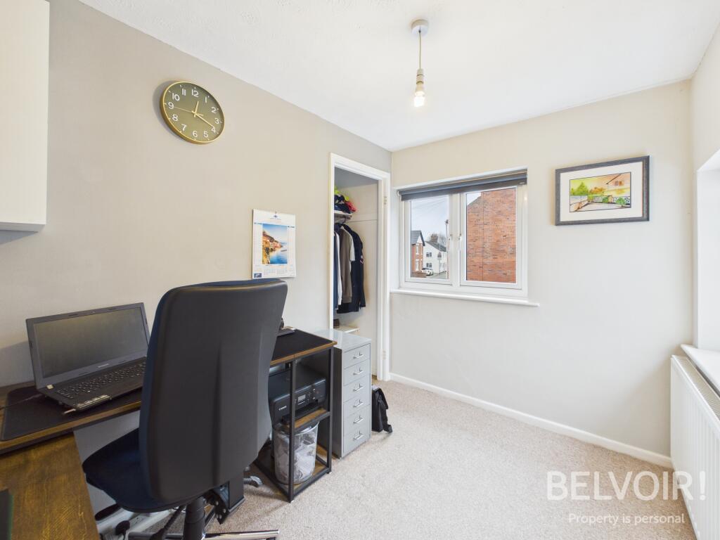
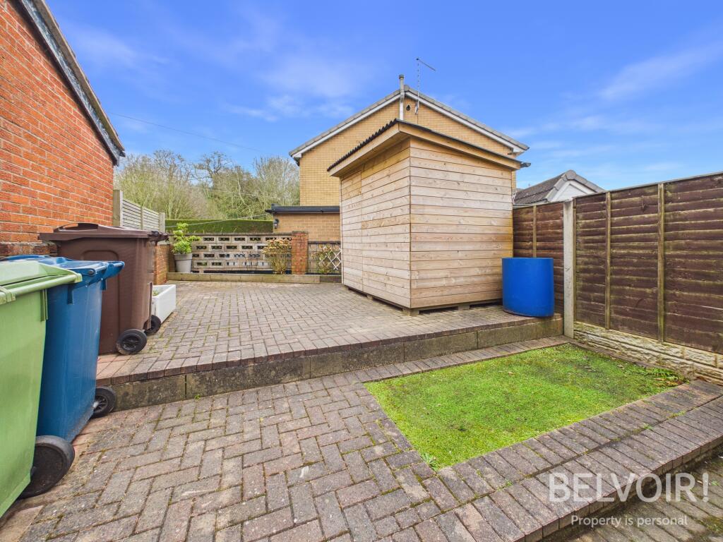
Photo 1 Photo 2 Photo 3 Photo 4 Photo 5 Photo 6 Photo 7 Photo 8 Photo 9 Photo 10
/ 10
Property details
Tenure
FREEHOLD
Council tax band
A
Last sold
£155,000
Local average
£216,352 (-12.2%)
Deprivation
Decile 4 (13,446 of 33,755)
Street crime
89 incidents within 1 mile (Apr 2026)
Key features
- Ideal First Time/Investment Purchase
- Close to Stone Town Centre
- Two Double Bedrooms
- Open Plan Living Space
- Fitted Kitchen
- Utility Room
- Recently Updated GCH Boiler
- uPCV Double Glazed Windows
- Private Enclosed Rear Garden
Additional details
- Heating
- Gas central
- Garden
- Private garden
- Listed property
- No
- Required access
- No
- Rights of way
- Yes
- Flood defences
- No
Description
Accommodation:
Open Plan Lounge/Diner: With composite front door, uPVC double glazed windows to the front and side, feature open plan staircase to the first floor
Fitted Kitchen: With a range of base and wall units, worktops, sink with mixer tap and drainer, integrated oven with gas hob, stainless splashback, space for freestanding tall fridge freezer, wall mounted GCH boiler (recently fitted -2 years), uPVC double glazed window to the rear
Utility Room: With worktop, space and plumbing for washing machine, door opening to the exterior
Landing: With loft space
Master Bedroom: With uPVC double glazed windows to the front and side
Bedroom Two: With walk in wardrobe/storage cupboard, uPVC double glazed windows to the front and side
Family Bathroom: With bath and shower over, inset wash hand basin with chrome mixer tap and vanity storage under, WC, towel radiator, uPVC double glazed frosted window
Externally: Low maintenance private enclosed rear garden with wooden storage shed and gated side pedestrian access to the front
EPC Asset Rating: C
Viewings: Please contact Belvoir Stone or Stafford office
Tenure: We are advised that the tenure is Freehold. Any interested parties are advised to confirm the details with solicitors before proceeding.
Services: All mains services are connected in accordance with normal terms of supply, telephone subject to normal terms and conditions. The gas and electrical appliances mentioned have not been tested by us and purchasers are therefore advised to undertake their own tests should they consider this necessary. All interested parties should obtain verification through their solicitor or surveyor before entering a legal commitment to purchase.
EPC rating: C. Tenure: Freehold, Planning permissions: not known Mobile signal information: usual providers
Listed by
Stafford
The Property Franchise Group
Reference: 173082173
EPC ratings on this postcode
We don't have a matched EPC for this property yet. Below are efficiency scores and details for other addresses on this postcode.
| Address | Current | Potential | Floor area | Age band | Type |
|---|---|---|---|---|---|
| 1 St Marys Mews, Station Road | 80 | 83 | 117 m² | England and Wales: 2003-2006 | Flat |
| 1 St. Marys Mews, Station Road | 82 | 85 | 117 m² | England and Wales: 2007 onwards | Flat |
| 1 St. Marys Mews, Station Road | 80 | 83 | 109 m² | England and Wales: 1996-2002 | Maisonette |
| 10 St Marys Mews, Station Road | 84 | 86 | 62 m² | England and Wales: 2003-2006 | Flat |
| 11 St. Marys Mews, Station Road | 81 | 83 | 91 m² | England and Wales: 2003-2006 | Flat |
| 11 St. Marys Mews, Station Road | 83 | 85 | 85 m² | England and Wales: 2007 onwards | Flat |
| 2 St. Marys Mews, Station Road | 80 | 81 | 84 m² | England and Wales: 2003-2006 | Flat |
| 2 St. Marys Mews, Station Road | 83 | 86 | 90 m² | England and Wales: 2007 onwards | Maisonette |
| 2 St. Marys Mews, Station Road, STONE | 80 | 81 | 84 m² | England and Wales: 2003-2006 | Flat |
| 3 St. Marys Mews, Station Road | 74 | 78 | 67 m² | England and Wales: 1900-1929 | Flat |
| 3 St. Marys Mews, Station Road | 83 | 85 | 67 m² | England and Wales: 2003-2006 | Flat |
| 4 St. Marys Mews, Station Road | 74 | 78 | 67 m² | England and Wales: 1900-1929 | Flat |
| 5 St. Marys Mews, Station Road | 73 | 75 | 80 m² | England and Wales: 1900-1929 | Flat |
| 6 St. Marys Mews, Station Road | 73 | 76 | 79 m² | England and Wales: 1900-1929 | Flat |
| 6 St. Marys Mews, Station Road | 81 | 82 | 76 m² | England and Wales: 2007 onwards | Flat |
Flood risk
Zone: 1
Risk: Low
Job (default Low)
Floorplans

Floorplan
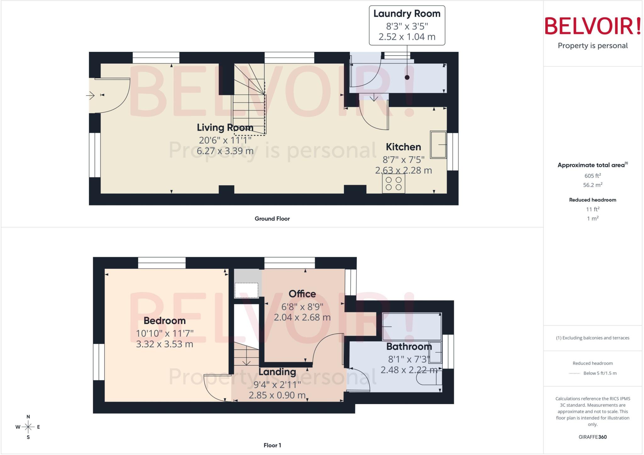
Floorplan
Price history
82% since 2006
| Event | Date | Price | % change |
|---|---|---|---|
| Listed for sale | — | £189,995 | +22.6% |
| Sold | 01/01/2023 (3 years ago) | £155,000 | +12.7% |
| Sold | 01/01/2020 (6 years ago) | £137,500 | +18.6% |
| Sold | 01/01/2014 (12 years ago) | £115,950 | +36.4% |
| Sold | 01/01/2006 (20 years ago) | £85,000 | — |
Source: HM Land Registry Price Paid Data. Crown copyright.
Sold Comparables
Same street and nearby sales within 0.25 miles (last 5 years). Data from Land Registry Price Paid.
| Address | Price | Date | Type |
|---|---|---|---|
| 90 PRIORY ROAD, STONE, STAFFORD, STAFFORDSHIRE, ST15 8NN | £177,000 | 19/12/2025 | Terraced |
| 96 CHURCH STREET, STONE, STAFFORD, STAFFORDSHIRE, ST15 8BD | £156,000 | 13/07/2023 | Terraced |
| REDHILL COTTAGES 3 REDHILL ROAD, STONE, STAFFORD, STAFFORDSHIRE, ST15 8BE | £162,600 | 26/05/2023 | Terraced |
| 136 CHURCH STREET, STONE, STAFFORD, STAFFORDSHIRE, ST15 8BW | £155,000 | 20/04/2023 | Terraced |
| 22 THE HEMPBUTTS, STONE, STAFFORD, STAFFORDSHIRE, ST15 8BT | £145,000 | 29/03/2023 | Terraced |
| REDHILL COTTAGES 1 REDHILL ROAD, STONE, STAFFORD, STAFFORDSHIRE, ST15 8BE | £100,000 | 25/11/2022 | Terraced |
| 53 CHURCH STREET, STONE, STAFFORD, STAFFORDSHIRE, ST15 8BW | £169,950 | 07/11/2022 | Terraced |
| 53 CHURCH STREET, STONE, STAFFORD, STAFFORDSHIRE, ST15 8BW | £165,000 | 31/10/2022 | Terraced |
| 2 THE HEMPBUTTS, STONE, STAFFORD, STAFFORDSHIRE, ST15 8BT | £165,000 | 19/10/2022 | Terraced |
| 3 NORBURY COURT, STONE, STAFFORD, STAFFORDSHIRE, ST15 8GY | £130,000 | 11/10/2022 | Terraced |
| 2 SYCAMORE ROAD, STONE, STAFFORD, STAFFORDSHIRE, ST15 8NJ | £167,000 | 03/08/2022 | Terraced |
| 99 PRIORY ROAD, STONE, STAFFORD, STAFFORDSHIRE, ST15 8NH | £161,000 | 16/05/2022 | Terraced |
| 37 CHURCH STREET, STONE, STAFFORD, STAFFORDSHIRE, ST15 8BW | £148,000 | 22/04/2022 | Terraced |
| 90 PRIORY ROAD, STONE, STAFFORD, STAFFORDSHIRE, ST15 8NN | £165,000 | 23/03/2022 | Terraced |
| 7 REDHILL ROAD, STONE, STAFFORD, STAFFORDSHIRE, ST15 8BG | £220,000 | 22/02/2022 | Terraced |
| MILL FARM BARNS 5 MILL STREET, STONE, STAFFORD, STAFFORDSHIRE, ST15 8BA | £380,000 | 15/11/2021 | Terraced |
| 2 OAK ROAD, STONE, STAFFORD, STAFFORDSHIRE, ST15 8NG | £145,000 | 29/10/2021 | Terraced |
| 37 REDHILL GARDENS, STONE, STAFFORD, STAFFORDSHIRE, ST15 8BH | £146,000 | 13/08/2021 | Terraced |
| 23 LICHFIELD STREET, STONE, STAFFORD, STAFFORDSHIRE, ST15 8NA | £190,000 | 30/07/2021 | Terraced |
| 5 THE HEMPBUTTS, STONE, STAFFORD, STAFFORDSHIRE, ST15 8BT | £140,000 | 02/07/2021 | Terraced |
Area average: £169,378 (20 sales)
Capital growth trend
Land Registry outcode average: last 12 months vs 5y and 10y ago (from sold prices).
House Price Index (HM Land Registry — official index, not sold-price averages): Stafford. Series: Terraced. As of March 2026.
Rental Range
Estimated market rent for Stafford. Low = conservative, Realistic = average, Optimistic = best case.
Based on Local Authority from postcode lookup → Stafford.
LHA (30th percentile) floor for Staffordshire North: £479/mo (Apr 2025 – Mar 2026)
Location
Address
Church Street
Nearby
Nearest stations, universities and amenities (distance from property).
| Type | Name | Distance |
|---|---|---|
| Shop | Morrisons | 0.2 miles |
| Shop | 3b Barbers | 0.2 miles |
| Bus stop | Altona Close | 0.2 miles |
| Bus stop | Abbey Street | 0.2 miles |
| Train station | Stone | 0.8 miles |
| Train station | Unknown | 4.5 miles |
| Hospital | Longton Cottage Hospital | 5.3 miles |
| Hospital | Beacon Park Hospital | 6.4 miles |
| University | Staffordshire University Blackheath Lane Site | 6.7 miles |
| University | University of Staffordshire Stoke Campus | 7.5 miles |
Street-level crime
| Category | Count |
|---|---|
| Violence and sexual offences | 40 |
| Anti-social behaviour | 13 |
| Shoplifting | 7 |
| Other theft | 6 |
| Public order | 6 |
| Criminal damage and arson | 5 |
| Burglary | 4 |
| Vehicle crime | 3 |
| Other crime | 2 |
| Bicycle theft | 1 |
| Robbery | 1 |
| Theft from the person | 1 |
| Total incidents | 89 |
Within 1 mile during Apr 2026. Source: data.police.uk (England & Wales).
Schools nearby
Nearest open schools with Ofsted ratings (England). Closed schools are not shown. Data from Get Information about Schools and Ofsted.
| Name | Type | Distance | Ofsted |
|---|---|---|---|
| St Dominic's Catholic Primary School | Primary | 0.4 miles | Outstanding — 22 May 2022 |
| Christ Church CofE First School | Primary | 0.4 miles | Good — 3 Mar 2014 |
| St Dominic's Priory School | Other | 0.5 miles | — (No rating) |
| St Michael's CofE (C) First School | Primary | 0.6 miles | Good — 4 Dec 2017 |
| Christ Church Academy | Primary | 0.6 miles | Good — 21 Dec 2012 |
Rental Comparables
Loading rental comparables for this postcode. Refresh in a few minutes.
Rent-driven metrics
Based on Area rent estimate.
- Rent ratio — Monthly rent ÷ purchase price (1% rule). 1%+ = strong, 0.8–1% = okay, <0.8% = weak for cashflow.
- Max investor price — Rent ÷ 0.8%; the price at which rent would be 0.8% of price (Stoke-style target).
- Target investor price — Rent ÷ 1%; the price at which rent would be 1% of price (strong cashflow band).
- Gross yield — Annual rent as % of purchase price (no costs).
Enter House Number
Enter the house number to help us retrieve more accurate pricing history and property data.
Please log in to submit or correct the house number for this listing.
Log in to continue