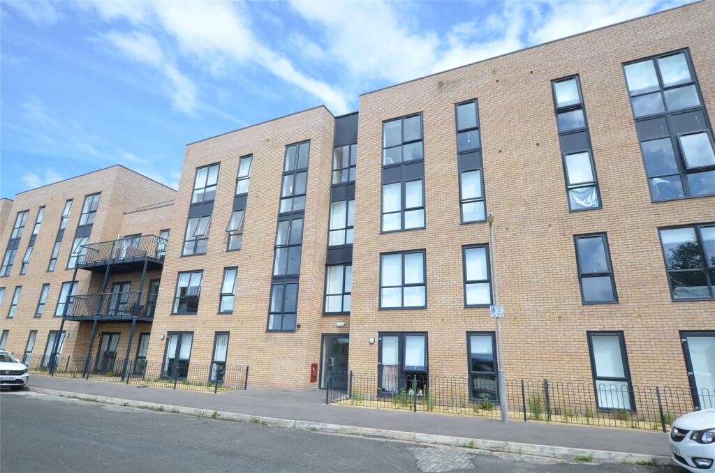
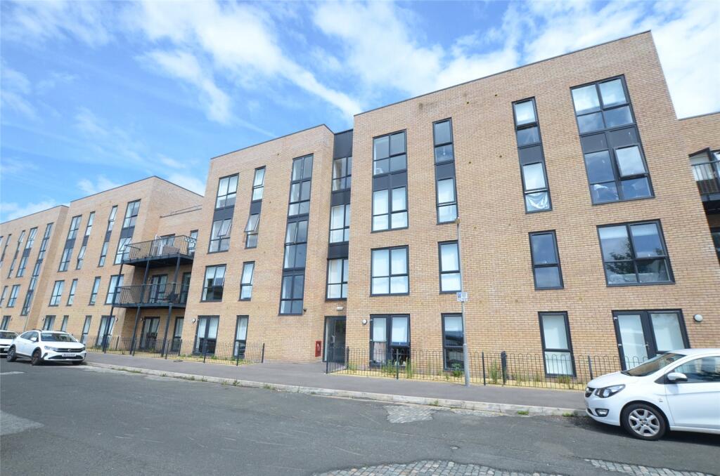
APARTMENT 17
52 HERIOT STREET, LIVERPOOL, MERSEYSIDE L5 7AA
£135,000


Property details
Tenure
LEASEHOLD
Council tax band
TBC
Last sold
£121,950 Jun 2023
Local average
£70,134 (+92.5%)
Street crime
547 incidents within 1 mile (Apr 2026)
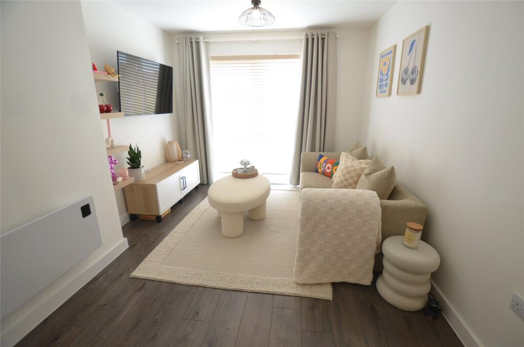
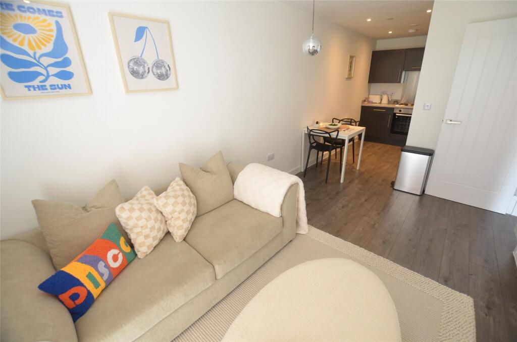
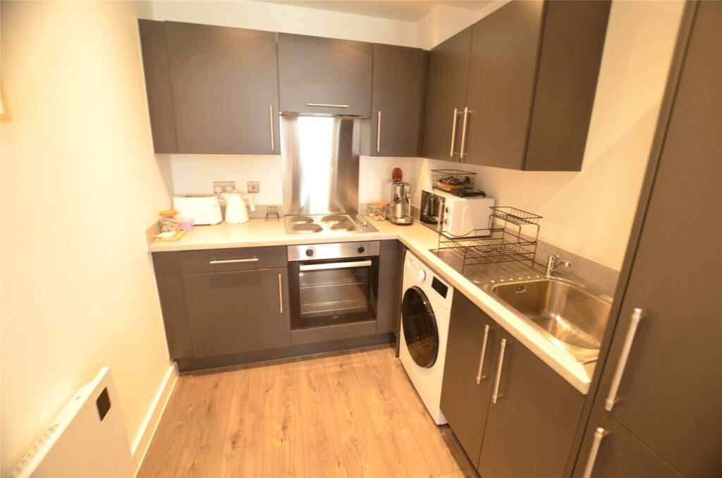
Key features
- Well Presented Second Floor Apartment
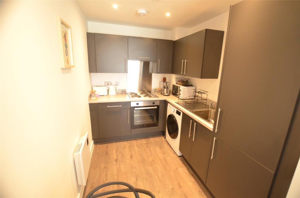
- Open Plan Lounge/Kitchen
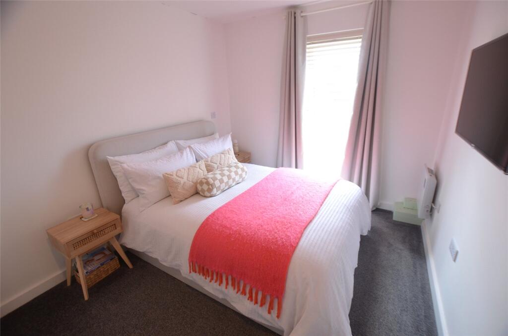
- One Bedroom
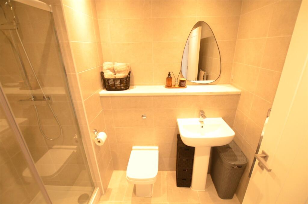
- Shower Room
- Double Glazed Windows
- Electric heating
- Ideal First Time Purchase
- Viewings Highly Recommended
Additional details
- Parking
- Yes
Description
Listed by
City Centre
Countrywide UK Sales - Connells
Reference: 164839118
EPC Rating & Upgrade Cost
Fetching EPC data… Refresh this page in a moment.
Flood risk
Zone: 1
Risk: Low
Job (default Low)
EPC Graphs
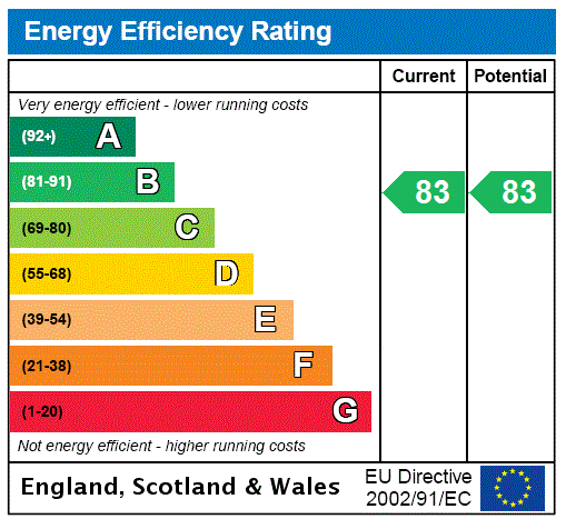
EPC Rating Graph
Price history
| Event | Date | Price | % change |
|---|---|---|---|
| Sold | 23/06/2023 (2 years ago) | £121,950 | — |
Source: HM Land Registry Price Paid Data. Crown copyright.
Sold Comparables
Same street and nearby sales within 0.25 miles (last 5 years). Data from Land Registry Price Paid.
| Address | Price | Date | Type |
|---|---|---|---|
| TOBACCO WHARF, 51 APARTMENT 4 COMMERCIAL ROAD, LIVERPOOL, MERSEYSIDE, L5 9XS | £108,000 | 19/12/2025 | Flat |
| TOBACCO WHARF, 51 APARTMENT 82 COMMERCIAL ROAD, LIVERPOOL, MERSEYSIDE, L5 9XB | £110,000 | 05/12/2025 | Flat |
| TOBACCO WHARF, 51 APARTMENT 43 COMMERCIAL ROAD, LIVERPOOL, MERSEYSIDE, L5 9XB | £105,000 | 06/11/2024 | Flat |
| Same street 52 APARTMENT 18 HERIOT STREET, LIVERPOOL, MERSEYSIDE, L5 7AA | £172,500 | 09/01/2024 | Flat |
| Same street 52 APARTMENT 11 HERIOT STREET, LIVERPOOL, MERSEYSIDE, L5 7AA | £120,000 | 16/11/2023 | Flat |
| 49 APARTMENT 6 GREAT MERSEY STREET, LIVERPOOL, MERSEYSIDE, L5 7SS | £160,000 | 16/11/2023 | Flat |
| Same street 52 APARTMENT 4 HERIOT STREET, LIVERPOOL, MERSEYSIDE, L5 7AA | £134,950 | 13/11/2023 | Flat |
| Same street 52 APARTMENT 3 HERIOT STREET, LIVERPOOL, MERSEYSIDE, L5 7AA | £129,950 | 13/10/2023 | Flat |
| Same street 52 APARTMENT 24 HERIOT STREET, LIVERPOOL, MERSEYSIDE, L5 7AA | £120,000 | 12/10/2023 | Flat |
| TOBACCO WHARF, 51 APARTMENT 86 COMMERCIAL ROAD, LIVERPOOL, MERSEYSIDE, L5 9XB | £200,000 | 18/09/2023 | Flat |
| TOBACCO WHARF, 51 APARTMENT 43 COMMERCIAL ROAD, LIVERPOOL, MERSEYSIDE, L5 9XB | £133,380 | 08/08/2023 | Flat |
| TOBACCO WHARF, 51 APARTMENT 27 COMMERCIAL ROAD, LIVERPOOL, MERSEYSIDE, L5 9XB | £132,210 | 08/08/2023 | Flat |
| TOBACCO WHARF, 51 APARTMENT 48 COMMERCIAL ROAD, LIVERPOOL, MERSEYSIDE, L5 9XB | £132,210 | 08/08/2023 | Flat |
| TOBACCO WHARF, 51 APARTMENT 78 COMMERCIAL ROAD, LIVERPOOL, MERSEYSIDE, L5 9XB | £132,210 | 08/08/2023 | Flat |
| TOBACCO WHARF, 51 APARTMENT 36 COMMERCIAL ROAD, LIVERPOOL, MERSEYSIDE, L5 9XB | £117,000 | 08/08/2023 | Flat |
| TOBACCO WHARF, 51 APARTMENT 80 COMMERCIAL ROAD, LIVERPOOL, MERSEYSIDE, L5 9XB | £132,210 | 08/08/2023 | Flat |
| TOBACCO WHARF, 51 APARTMENT 50 COMMERCIAL ROAD, LIVERPOOL, MERSEYSIDE, L5 9XB | £132,210 | 08/08/2023 | Flat |
| TOBACCO WHARF, 51 APARTMENT 98 COMMERCIAL ROAD, LIVERPOOL, MERSEYSIDE, L5 9XB | £132,210 | 08/08/2023 | Flat |
| TOBACCO WHARF, 51 APARTMENT 56 COMMERCIAL ROAD, LIVERPOOL, MERSEYSIDE, L5 9XB | £132,210 | 08/08/2023 | Flat |
| Same street 52 APARTMENT 2 HERIOT STREET, LIVERPOOL, MERSEYSIDE, L5 7AA | £149,995 | 27/06/2023 | Flat |
| 49 APARTMENT 5 GREAT MERSEY STREET, LIVERPOOL, MERSEYSIDE, L5 7SS | £120,000 | 21/06/2023 | Flat |
| Same street 52 APARTMENT 8 HERIOT STREET, LIVERPOOL, MERSEYSIDE, L5 7AA | £104,995 | 05/06/2023 | Flat |
| Same street 52 APARTMENT 21 HERIOT STREET, LIVERPOOL, MERSEYSIDE, L5 7AA | £105,995 | 02/06/2023 | Flat |
| Same street 52 APARTMENT 25 HERIOT STREET, LIVERPOOL, MERSEYSIDE, L5 7AA | £110,995 | 02/06/2023 | Flat |
| Same street 52 APARTMENT 26 HERIOT STREET, LIVERPOOL, MERSEYSIDE, L5 7AA | £101,995 | 01/06/2023 | Flat |
| Same street 52 APARTMENT 22 HERIOT STREET, LIVERPOOL, MERSEYSIDE, L5 7AA | £141,995 | 25/05/2023 | Flat |
| Same street 52 APARTMENT 27 HERIOT STREET, LIVERPOOL, MERSEYSIDE, L5 7AA | £107,995 | 24/05/2023 | Flat |
| 11 APARTMENT 1 LEMON STREET, LIVERPOOL, MERSEYSIDE, L5 7TB | £145,000 | 24/05/2023 | Flat |
| Same street 52 APARTMENT 12 HERIOT STREET, LIVERPOOL, MERSEYSIDE, L5 7AA | £99,950 | 23/05/2023 | Flat |
| Same street 52 APARTMENT 28 HERIOT STREET, LIVERPOOL, MERSEYSIDE, L5 7AA | £153,995 | 23/05/2023 | Flat |
| Same street 52 APARTMENT 19 HERIOT STREET, LIVERPOOL, MERSEYSIDE, L5 7AA | £98,500 | 23/05/2023 | Flat |
| TOBACCO WHARF, 51 APARTMENT 73 COMMERCIAL ROAD, LIVERPOOL, MERSEYSIDE, L5 9XB | £132,210 | 08/01/2023 | Flat |
| TOBACCO WHARF, 51 APARTMENT 116 COMMERCIAL ROAD, LIVERPOOL, MERSEYSIDE, L5 9XB | £70,000 | 16/12/2022 | Flat |
| TOBACCO WHARF, 51 APARTMENT 21 COMMERCIAL ROAD, LIVERPOOL, MERSEYSIDE, L5 9XS | £73,000 | 16/12/2022 | Flat |
| TOBACCO WHARF, 51 APARTMENT 26 COMMERCIAL ROAD, LIVERPOOL, MERSEYSIDE, L5 9XS | £115,000 | 12/07/2022 | Flat |
Street average: £123,587 (15 sales)
Area average: £125,703 (20 sales)
Capital growth trend
Land Registry outcode average: last 12 months vs 5y and 10y ago (from sold prices).
House Price Index (HM Land Registry — official index, not sold-price averages): North West. Series: Flats and maisonettes. As of March 2026.
Company ownership
Registered legal owner is a company.
Company: NAV INVESTMENT LTD (10452974)
Rental Range
Estimated market rent for North West. Low = conservative, Realistic = average, Optimistic = best case.
Based on Postcode area L → North West.
LHA (30th percentile) floor for Greater Liverpool: £499/mo (Apr 2025 – Mar 2026)
Location
Nearby
Nearest stations, universities and amenities (distance from property).
| Type | Name | Distance |
|---|---|---|
| Shop | Kirkdale General Store | 0.1 miles |
| Bus stop | STANLEY ROAD/STERLING WAY | 0.1 miles |
| Bus stop | STANLEY ROAD/BOUNDARY STREET | 0.1 miles |
| Shop | Peter Coyne Funeral Service | 0.1 miles |
| Train station | Sandhills | 0.3 miles |
| Hospital | Kirkdale Medical Centre | 0.6 miles |
| Train station | Bank Hall | 0.7 miles |
| Hospital | Walton Manor Residential and Nursing Home | 0.7 miles |
| University | Liverpool John Moores University City Campus | 1.1 miles |
| University | Liverpool Hope University | 1.2 miles |
Street-level crime
| Category | Count |
|---|---|
| Violence and sexual offences | 185 |
| Public order | 62 |
| Anti-social behaviour | 60 |
| Shoplifting | 58 |
| Drugs | 54 |
| Criminal damage and arson | 42 |
| Vehicle crime | 25 |
| Other theft | 21 |
| Other crime | 17 |
| Burglary | 10 |
| Possession of weapons | 6 |
| Bicycle theft | 3 |
| Robbery | 2 |
| Theft from the person | 2 |
| Total incidents | 547 |
Within 1 mile during Apr 2026. Source: data.police.uk (England & Wales).
Schools nearby
Nearest open schools with Ofsted ratings (England). Closed schools are not shown. Data from Get Information about Schools and Ofsted.
| Name | Type | Distance | Ofsted |
|---|---|---|---|
| Notre Dame Catholic Academy | Secondary | 0.3 miles | Requires improvement — 17 Jul 2022 |
| St John's Catholic Primary School | Primary | 0.5 miles | — (Inspected (no overall grade)) |
| Our Lady Immaculate Catholic Primary School | Primary | 0.5 miles | Good — 21 Nov 2023 |
| The Beacon Church of England Primary School | Primary | 0.6 miles | Outstanding — 20 Mar 2014 |
| The Trinity Catholic Academy | Primary | 0.6 miles | Inadequate — 13 May 2019 |
Rental Comparables
Rental listings exist nearby, but none matched the 1-bedroom count for this property.
Rent-driven metrics
Based on Area rent estimate.
- Rent ratio — Monthly rent ÷ purchase price (1% rule). 1%+ = strong, 0.8–1% = okay, <0.8% = weak for cashflow.
- Max investor price — Rent ÷ 0.8%; the price at which rent would be 0.8% of price (Stoke-style target).
- Target investor price — Rent ÷ 1%; the price at which rent would be 1% of price (strong cashflow band).
- Gross yield — Annual rent as % of purchase price (no costs).