8B
GALLOWAY ROAD, POOLE, POOLE BH15 4JX
£575 pcm
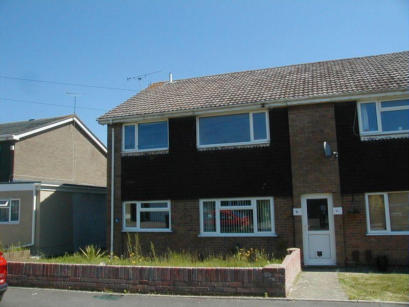
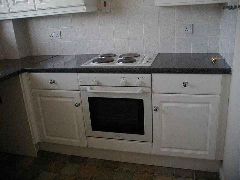
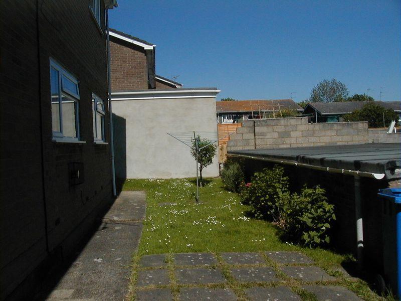
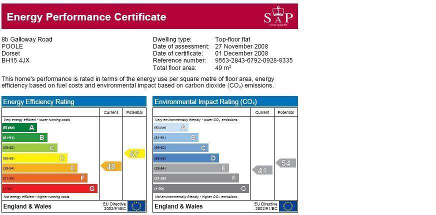
Photo 1 Photo 2 Photo 3 EPC
/ 4
Property details
Floor area
55 m²
EPC rating
C
Year built
England and Wales: 1967-1975
Deprivation
Decile 5 (16,524 of 33,755)
Street crime
102 incidents within 1 mile (Apr 2026)
Additional details
- Parking
- Yes
Description
Two double bedrooms
Living room
Kitchen
Bathroom
Garage
Communal grounds
From Poole bridge proceed along the Blandford Road, turn left into Dawkins Road, immediately right into Carters Avenue, left into Galloway Road where the property will be found on the right
Downstairs communal door access to this property and one other, stairs leading to entrance door
Hallway:
Cupboard housing hot water cylinder and shelving, overhead top cupboard, hatch into loft space
Living room: 14' 4'' x 10' 9' (4.27m 1.22m' x 3.05m 2.74m)'
UPVC double glazed window to front aspect, electric storage heater, coved and artexed ceiling
Bedroom one: 12' 2'' x 10' (3.66m 0.61m' x 3.05m)
UPVC double glazedw indow to rear aspect, electric storage heater, coved and artexed ceiling
Bedroom two: 9' 11'' x 9' (2.74m 3.35m' x 2.74m)
UPVC double glazed window to rear aspect, electric storage heater, coved and artexed ceiling, built in wardrboe with hanging rail and shelving
Kitchen: 8' 8'' x 7' 6' (2.44m 2.44m' x 2.13m 1.83m)'
UPVC double glazed window to front aspect, modern white fitted kitchen with wall and base units with rolled edge laminated worktops, fitted electric oven and electric hob with overhead extractor fan, inset single sink and drainer, space for washing machine, space for fridge/freezer, coved and artexed ceiling
Bathroom: 6' 4'' x 5' 6' (1.83m 1.22m' x 1.52m 1.83m)'
Frosted UPVC double glazed window to side aspect, white suite consisting of bath with wall mounted electric shower unit, low level wc, hand basin, fully tiled walls
Garage in block
Communal grounds with rotary drying washing lines
THE PROPERTY MISDESCRIPTIONS ACT 1991
The Agent has not tested any apparatus, equipment, fixtures and fittings or services and so cannot verify that they are in working order or fit for the purpose. A Buyer is advised to obtain verification from their Solicitor or Surveyor. References to the Tenure of a Property are based on information supplied by the Seller. The Agent has not had sight of the title documents. A Buyer is advised to obtain verification from their Solicitor. Items shown in photographs are NOT included unless specifically mentioned within the sales particulars. They may however be available by separate negotiation. Buyers must check the availability of any property and make an appointment to view before embarking on any journey to see a property.
Listed by
Bournemouth
Atkins
Reference: 23745988
EPC Rating & Upgrade Cost
Current rating: C
Potential rating: C
Inspection date: 25/04/2019
Expiry date: 24/04/2029
Current heating cost: £356/year
Potential heating cost: £260/year
Est. upgrade cost to C: £10,020
Recommendations
- Cavity wall insulation (£500 - £1,500)
- 50 mm internal or external wall insulation (£4,000 - £14,000)
- Low energy lighting for all fixed outlets (£20)
Flood risk
Zone: 1
Risk: Low
Job (default Low)
Rental Range
Estimated market rent for Bournemouth, Christchurch and Poole. Low = conservative, Realistic = average, Optimistic = best case.
Based on Local Authority from postcode lookup → Bournemouth, Christchurch and Poole.
LHA (30th percentile) floor for West Wiltshire: £723/mo (Apr 2025 – Mar 2026)
Location
Nearby
Nearest stations, universities and amenities (distance from property).
| Type | Name | Distance |
|---|---|---|
| Train station | Hamworthy | 0.1 miles |
| Bus stop | Hamworthy Fire Station | 0.1 miles |
| Shop | Lidl | 0.2 miles |
| Shop | Kwik Fit | 0.3 miles |
| Train station | Poole | 1.6 miles |
| Hospital | Harbour Hospital | 1.9 miles |
| Hospital | St Mary's Hospital Outpatient Assessment Centre | 1.9 miles |
| University | Arts University Bournemouth | 5.4 miles |
| University | Bournemouth University (Talbot Campus) | 5.5 miles |
Street-level crime
| Category | Count |
|---|---|
| Anti-social behaviour | 31 |
| Violence and sexual offences | 23 |
| Criminal damage and arson | 12 |
| Other theft | 9 |
| Vehicle crime | 8 |
| Burglary | 6 |
| Public order | 5 |
| Drugs | 4 |
| Bicycle theft | 2 |
| Other crime | 1 |
| Shoplifting | 1 |
| Total incidents | 102 |
Within 1 mile during Apr 2026. Source: data.police.uk (England & Wales).
Schools nearby
Nearest open schools with Ofsted ratings (England). Closed schools are not shown. Data from Get Information about Schools and Ofsted.
| Name | Type | Distance | Ofsted |
|---|---|---|---|
| Bayside Academy | Primary | 0.4 miles | Good — 25 Jul 2022 |
| Twin Sails Infant and Nursery School | Primary | 0.9 miles | Good — 15 Jul 2015 |
| The Cornerstone Academy | Secondary | 0.9 miles | Good — 27 Feb 2017 |
| Yarrells Preparatory School | Other | 1.0 miles | — (No rating) |
| Hamworthy Park Junior School | Primary | 1.1 miles | Good — 21 Jun 2016 |
Rental Comparables
Rental comparables are temporarily unavailable while listing-site fetches are paused. Try again later.