41 LANCASTER ROAD
SOUTHPORT, SOUTHPORT, MERSEYSIDE PR8 2LA
POA
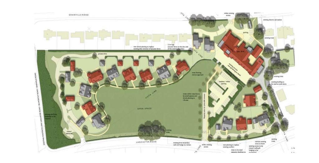
Photo 1
/ 1
Property details
Last sold
£1,300,000 Aug 2007
Local average
£637,641 (-100%)
Deprivation
Decile 7 (23,434 of 33,755)
Street crime
52 incidents within 1 mile (Mar 2026)
Key features
- Stunning Development Opportunity
- Subject To Planning
- Prime Location
- Planning Submitted for 16 Detached Houses & 27 Apartments
- Site Area 9.6 Acres (approx)
Description
Listed by
Curtis & Bains- Manchester
Countrywide UK Sales - Connells
Reference: 37435646
EPC Rating & Upgrade Cost
Fetching EPC data… Refresh this page in a moment.
Flood risk
Zone: 1
Risk: Low
Job (default Low)
FENSA Certificates
This property has 1 FENSA certificate(s) on record, indicating window/door installations by FENSA-approved installers.
FENSA Certificate #2358584
Property Details
Street: 41 Lancaster Road
Town: SOUTHPORT
Postcode: PR8 2LA
Installation Details
Items: 14 windows
Certificate Issued: 04/01/2005
Work Completed: 22/11/2004
This certificate data was retrieved from FENSA's database
What is FENSA? FENSA (Fenestration Self-Assessment Scheme) is a government-authorised scheme that monitors building regulation compliance for replacement windows and doors. Certificates indicate that work was completed by FENSA-approved installers.
Price history
122% since 2004
| Event | Date | Price | % change |
|---|---|---|---|
| Sold | 01/08/2007 (18 years ago) | £1,300,000 | +122.2% |
| Sold | 24/08/2004 (21 years ago) | £585,000 | — |
Source: HM Land Registry Price Paid Data. Crown copyright.
Sold Comparables
Same street and nearby sales within 0.25 miles (last 5 years). Data from Land Registry Price Paid.
| Address | Price | Date | Type |
|---|---|---|---|
| Same street 43 LANCASTER ROAD, SOUTHPORT, SEFTON, MERSEYSIDE, PR8 2LA | £100 | 17/10/2023 | Other |
| Same street 33 LANCASTER ROAD, SOUTHPORT, SEFTON, MERSEYSIDE, PR8 2LA | £100 | 10/10/2023 | Other |
| 4 GROSVENOR ROAD, BIRKDALE, SOUTHPORT, SEFTON, MERSEYSIDE, PR8 2JE | £6,000 | 22/08/2023 | Other |
| 2 GRANVILLE ROAD, SOUTHPORT, SEFTON, MERSEYSIDE, PR8 2HU | £5,000 | 02/05/2023 | Other |
| 17D GROSVENOR ROAD, BIRKDALE, SOUTHPORT, SEFTON, MERSEYSIDE, PR8 2JG | £3,000 | 09/09/2022 | Other |
| 37 WATERLOO ROAD, BIRKDALE, SOUTHPORT, SEFTON, MERSEYSIDE, PR8 2NQ | £1,800,000 | 02/09/2022 | Other |
| 37 WATERLOO ROAD, BIRKDALE, SOUTHPORT, SEFTON, MERSEYSIDE, PR8 2NQ | £1,800,000 | 02/09/2022 | Other |
| 19A GROSVENOR ROAD, BIRKDALE, SOUTHPORT, SEFTON, MERSEYSIDE, PR8 2JG | £3,500 | 18/07/2022 | Other |
| 12 GROSVENOR ROAD, SOUTHPORT, SEFTON, MERSEYSIDE, PR8 2JF | £600,000 | 19/07/2021 | Other |
Street average: £100 (2 sales)
Area average: £602,500 (7 sales)
Capital growth trend
Land Registry outcode average: last 12 months vs 5y and 10y ago (from sold prices).
House Price Index (HM Land Registry — official index, not sold-price averages): Sefton. Series: All dwelling types. As of March 2026.
Rental Range
Estimated market rent for Sefton. Low = conservative, Realistic = average, Optimistic = best case.
Based on Local Authority from postcode lookup → Sefton.
LHA (30th percentile) floor for Southport: Apr 2025 – Mar 2026
Location
Nearby
Nearest stations, universities and amenities (distance from property).
| Type | Name | Distance |
|---|---|---|
| Bus stop | WATERLOO RD/SELWORTHY RD | 0.2 miles |
| Bus stop | GROSVENOR RD/LANCASTER RD | 0.2 miles |
| Train station | Hillside | 0.6 miles |
| Shop | Majestic | 0.7 miles |
| Shop | Birkdale Kitchen Co. | 0.7 miles |
| Train station | Birkdale | 0.7 miles |
| Hospital | St Marks Medical Centre | 1.9 miles |
| Hospital | Hartley Hospital | 1.9 miles |
| University | Milton House | 8.0 miles |
| University | Edge Hill University | 8.3 miles |
Street-level crime
| Category | Count |
|---|---|
| Shoplifting | 19 |
| Violence and sexual offences | 15 |
| Public order | 6 |
| Other theft | 5 |
| Anti-social behaviour | 3 |
| Burglary | 1 |
| Criminal damage and arson | 1 |
| Other crime | 1 |
| Theft from the person | 1 |
| Total incidents | 52 |
Within 1 mile during Mar 2026. Source: data.police.uk (England & Wales).
Schools nearby
Nearest open schools with Ofsted ratings (England). Closed schools are not shown. Data from Get Information about Schools and Ofsted.
| Name | Type | Distance | Ofsted |
|---|---|---|---|
| Greenbank High School | Secondary | 0.6 miles | Good — 21 Nov 2022 |
| Birkdale Primary School | Primary | 1.1 miles | Good — 28 Mar 2014 |
| Our Lady of Lourdes Catholic Primary School | Primary | 1.1 miles | Good — 16 Jul 2015 |
| Christ The King Catholic High School and Sixth Form Centre | Secondary | 1.2 miles | Good — 18 Jan 2024 |
| Farnborough Road Junior School | Primary | 1.2 miles | Good — 16 May 2014 |
Rental Comparables
Residential lets from OpenRent and Rightmove for the area. Bedroom counts vary — use the Beds column to compare like-for-like lets. Student lets are excluded.
| Title | Rent | Beds | Distance | As seen on |
|---|---|---|---|---|
| 1 Bed Flat, Grosvenor Road, PR8 | £895/mo | 1 | 0.29 miles | OpenRent |
| 4 Bed Terraced House, Windsor Court, PR8 | £1,850/mo | 4 | 0.43 miles | OpenRent |
| 5 Bed Detached House, Lulworth Road, PR8 | £7,000/mo | 5 | 0.51 miles | OpenRent |
| 2 Bed Flat, Trafalgar Road, PR8 | £775/mo | 2 | 0.53 miles | OpenRent |
| 1 Bed Flat, Trafalgar Road, PR8 | £550/mo | 1 | 0.54 miles | OpenRent |
| 1 Bed Flat, Westcliffe Road, PR8 | £710/mo | 1 | 0.66 miles | OpenRent |
| 1 Bed Flat, Westcliffe Road, PR8 | £710/mo | 1 | 0.66 miles | OpenRent |
| 2 Bed Flat, Westcliffe Road, PR8 | £875/mo | 2 | 0.66 miles | OpenRent |
| 2 Bed Penthouse, Birkdale, PR8 | £995/mo | 2 | 0.78 miles | OpenRent |
| 1 Bed Flat, Brighton Rd, PR8 | £650/mo | 1 | 0.86 miles | OpenRent |
| 1 Bed Flat, Westcliffe Road, PR8 | £2,300/mo | 1 | 0.92 miles | OpenRent |
| 2 Bed Flat, Westcliffe Road, PR8 | £2,500/mo | 2 | 0.94 miles | OpenRent |
| 2 Bed Flat, Westcliffe Road, PR8 | £2,600/mo | 2 | 0.94 miles | OpenRent |
| 3 Bed Flat, Westcliffe Road, PR8 | £3,033/mo | 3 | 0.94 miles | OpenRent |
| 3 Bed Penthouse, Penthouse, PR8 | £3,033/mo | 3 | 0.94 miles | OpenRent |
| 4 Bed Detached House, Lynton Road, PR8 | £2,700/mo | 4 | 0.94 miles | OpenRent |
| 2 Bed Terraced House, Grove Terrace, PR8 | £1,200/mo | 2 | 1.03 miles | OpenRent |
| 1 Bed Flat, Upper Aughton Road, PR8 | £600/mo | 1 | 1.03 miles | OpenRent |
| 2 Bed Flat, Part St, PR8 | £1,200/mo | 2 | 1.11 miles | OpenRent |
Average rent: £1,799/mo (19 listings)
Rent-driven metrics
Based on OpenRent comparables.
- Rent ratio — Monthly rent ÷ purchase price (1% rule). 1%+ = strong, 0.8–1% = okay, <0.8% = weak for cashflow.
- Max investor price — Rent ÷ 0.8%; the price at which rent would be 0.8% of price (Stoke-style target).
- Target investor price — Rent ÷ 1%; the price at which rent would be 1% of price (strong cashflow band).
- Gross yield — Annual rent as % of purchase price (no costs).
- Cashflow — Rent minus mortgage, 10% maintenance, £25/mo compliance. Assumes 75% LTV, 3.95% APR (5yr fixed), 25yr term.
- ROI — Annual profit ÷ cash in (deposit + 4% purchase costs).