18 WAVENEY PLACE
HARLESTON, NORFOLK IP20 9EW
£319,995


Property details
Tenure
LEASEHOLD
Floor area
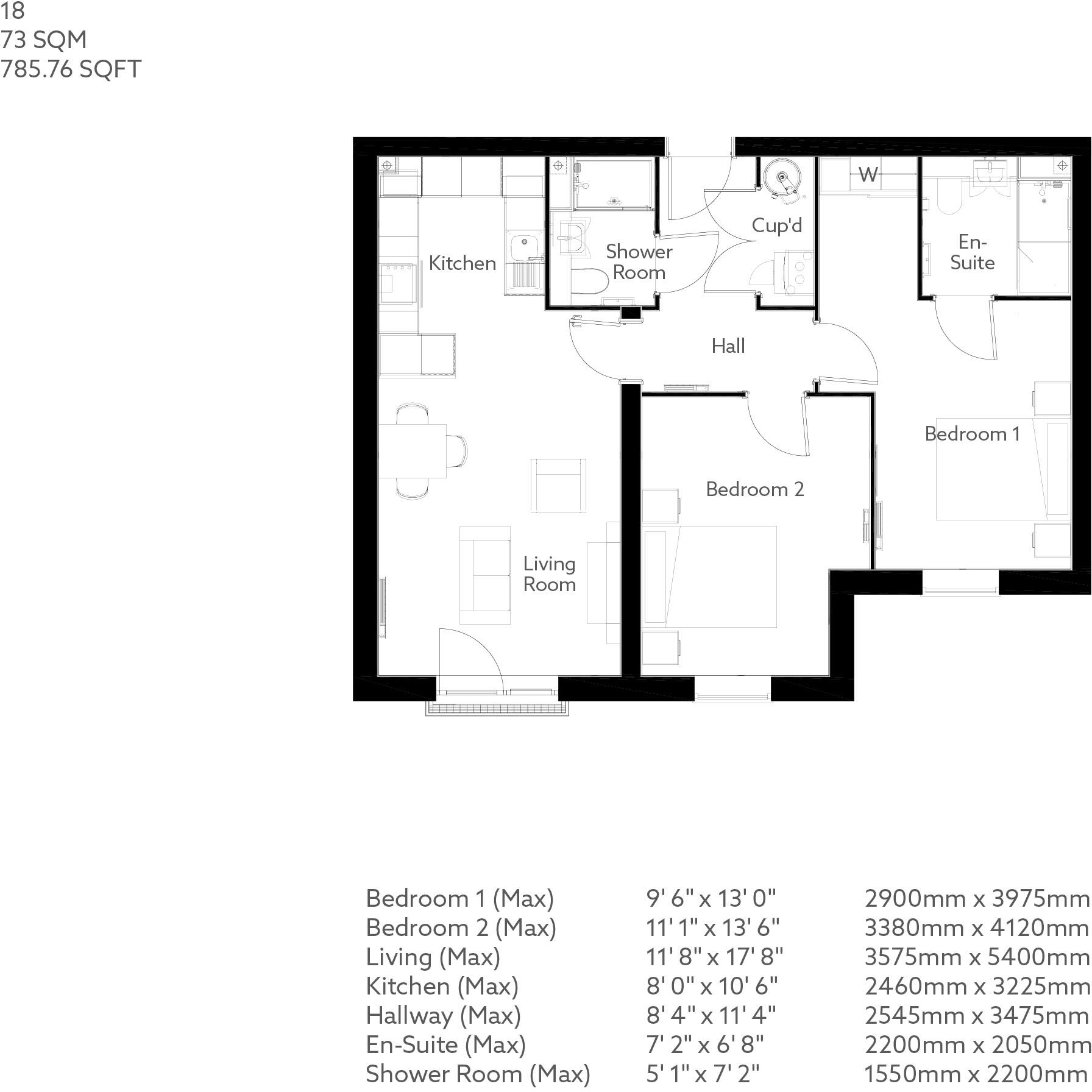
73 m²
Council tax band
TBC
EPC rating
B
Last sold
£309,995 Apr 2025
Price per m²
£4,383/m²
Local average
£475,000 (-32.6%)
Deprivation
Decile 7 (22,912 of 33,755)
Street crime
13 incidents within 1 mile (Apr 2026)
Key features
- A stunning selection of retirement apartments, cottages and bungalows for the over 60s
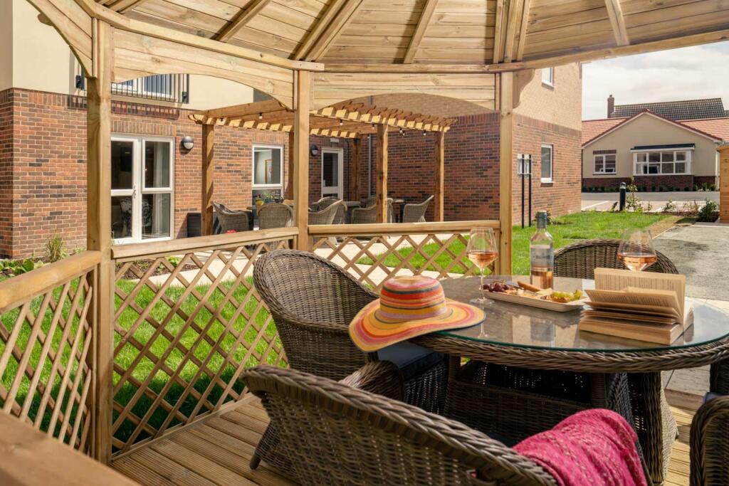
- Beautiful landscaped gardens
- New homes for sale in Norfolk close to Harleston town centre and local amenities
- Stylish communal areas for you to enjoy time with friends
- Exclusive private community
- Balconies available in select apartments
- South facing
- Landscaped gardens
- Car parking
- Guest suite
Additional details
- Parking
- Yes
- Garden
- Yes
Description
A beautiful two-bedroom apartment at our new development at Waveney Place. Benefitting from a spacious open plan living/dining room which leads to the kitchen.
Bedroom one has a luxurious en-suite shower room and a fitted wardrobe. The main shower room has a large shower and vanity unit for storage under the sink. Bedroom two could be used as a double bedroom or a study.
There is also a useful storage cupboard located in the hall, housing the washer dryer.
A glazed door from the living room looks out to a South facing Juliette balcony, overlooking the landscaped gardens.
Room Dimensions
First Floor
Listed by
Waveney Place
McCarthy & Stone
Reference: 156045866
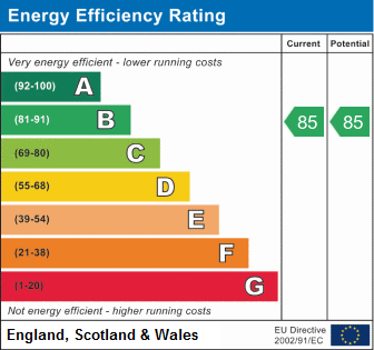
EPC Rating & Upgrade Cost
Current rating: B
Potential rating: B
Inspection date: 18/05/2023
Expiry date: 17/05/2033
Current heating cost: £81/year
Potential heating cost: £81/year
Flood risk
Zone: 1
Risk: Low
Job (default Low)
Floorplans
Floorplan
Price history
| Event | Date | Price | % change |
|---|---|---|---|
| Sold | 15/04/2025 (1 year ago) | £309,995 | — |
Source: HM Land Registry Price Paid Data. Crown copyright.
Sold Comparables
Same street and nearby sales within 0.25 miles (last 5 years). Data from Land Registry Price Paid.
| Address | Price | Date | Type |
|---|---|---|---|
| MICRON HOUSE LONDON ROAD, HARLESTON, SOUTH NORFOLK, NORFOLK, IP20 9BH | £195,000 | 24/11/2025 | Other |
| 42 - 44 FULLER ROAD, HARLESTON, SOUTH NORFOLK, NORFOLK, IP20 9EA | £770,000 | 30/09/2025 | Other |
| 3 MARKET PLACE, HARLESTON, SOUTH NORFOLK, NORFOLK, IP20 9AD | £315,000 | 19/09/2023 | Other |
| 3A CHURCH STREET, HARLESTON, SOUTH NORFOLK, NORFOLK, IP20 9BB | £80,000 | 02/12/2022 | Other |
| 2 CHURCH STREET, HARLESTON, SOUTH NORFOLK, NORFOLK, IP20 9BB | £163,800 | 05/09/2022 | Other |
| 2 THE THOROUGHFARE, HARLESTON, SOUTH NORFOLK, NORFOLK, IP20 9AX | £190,000 | 08/07/2022 | Other |
| 4 THE THOROUGHFARE, HARLESTON, SOUTH NORFOLK, NORFOLK, IP20 9AX | £140,000 | 18/03/2022 | Other |
| 2 CHAFFINCH MEWS, HARLESTON, SOUTH NORFOLK, NORFOLK, IP20 9FD | £220,000 | 18/02/2022 | Other |
| 7 CHURCH STREET, HARLESTON, SOUTH NORFOLK, NORFOLK, IP20 9BB | £150,000 | 29/06/2021 | Other |
| APOLLO CLUB MENDHAM LANE, HARLESTON, SOUTH NORFOLK, NORFOLK, IP20 9DN | £700,000 | 18/06/2021 | Other |
Area average: £292,380 (10 sales)
Capital growth trend
Land Registry outcode average: last 12 months vs 5y and 10y ago (from sold prices).
House Price Index (HM Land Registry — official index, not sold-price averages): South Norfolk. Series: All dwelling types. As of March 2026.
Rental Range
Estimated market rent for South Norfolk. Low = conservative, Realistic = average, Optimistic = best case.
Based on Local Authority from postcode lookup → South Norfolk.
LHA (30th percentile) floor for Central Norfolk & Norwich: £693/mo (Apr 2025 – Mar 2026)
Location
Nearby
Nearest stations, universities and amenities (distance from property).
| Type | Name | Distance |
|---|---|---|
| Shop | Lings.com Motor Group | 0.1 miles |
| Shop | The Grooming Parlour | 0.2 miles |
| Bus stop | Malthouse Court, opp | 0.2 miles |
| Bus stop | Love Lane, opp | 0.2 miles |
| Hospital | Richmond House | 0.4 miles |
| Train station | Diss | 7.7 miles |
| Hospital | Hartismere Hospital | 8.6 miles |
| Train station | Halesworth | 9.3 miles |
Street-level crime
| Category | Count |
|---|---|
| Violence and sexual offences | 6 |
| Anti-social behaviour | 2 |
| Criminal damage and arson | 2 |
| Burglary | 1 |
| Other theft | 1 |
| Public order | 1 |
| Total incidents | 13 |
Within 1 mile during Apr 2026. Source: data.police.uk (England & Wales).
Schools nearby
Nearest open schools with Ofsted ratings (England). Closed schools are not shown. Data from Get Information about Schools and Ofsted.
| Name | Type | Distance | Ofsted |
|---|---|---|---|
| The Harleston Sancroft Academy (a 3-16 Church of England School) | Other | 0.3 miles | — (No rating) |
| Mendham Primary School | Primary | 1.5 miles | Good — 11 Sep 2013 |
| Alburgh With Denton Church of England Primary Academy | Primary | 2.9 miles | Good — 29 Jan 2019 |
| Pulham Church of England Primary School | Primary | 3.6 miles | Requires improvement — 15 Jan 2023 |
| Fressingfield Church of England Primary School | Primary | 3.7 miles | Good — 6 Sep 2016 |
Rental Comparables
Rental comparables are temporarily unavailable while listing-site fetches are paused. Try again later.
Rent-driven metrics
Based on Area rent estimate.
- Rent ratio — Monthly rent ÷ purchase price (1% rule). 1%+ = strong, 0.8–1% = okay, <0.8% = weak for cashflow.
- Max investor price — Rent ÷ 0.8%; the price at which rent would be 0.8% of price (Stoke-style target).
- Target investor price — Rent ÷ 1%; the price at which rent would be 1% of price (strong cashflow band).
- Gross yield — Annual rent as % of purchase price (no costs).