10 SWAN LANE
ASHFORD, SELLINDGE, KENT TN25 6EP
£295,000
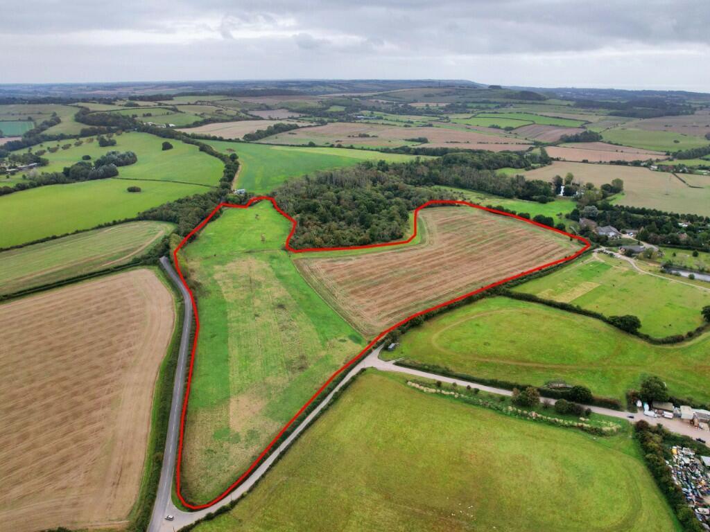
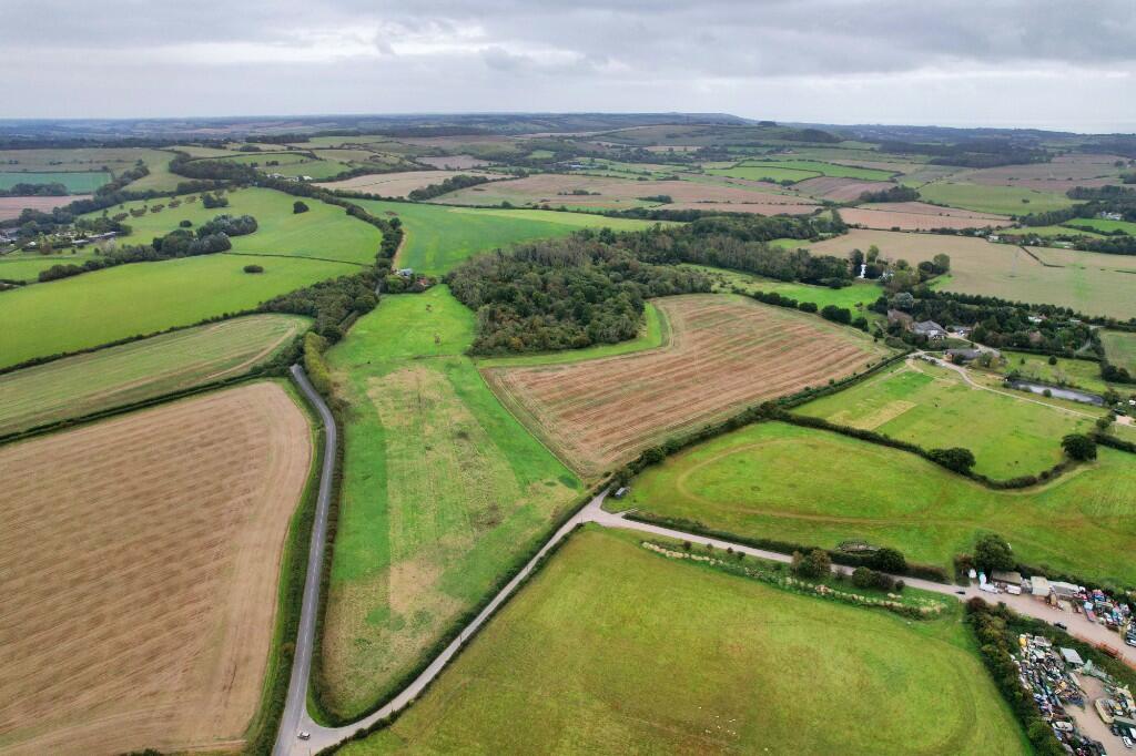
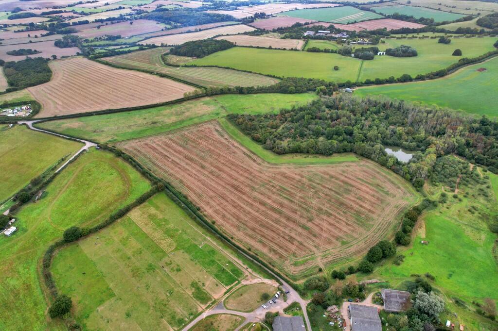
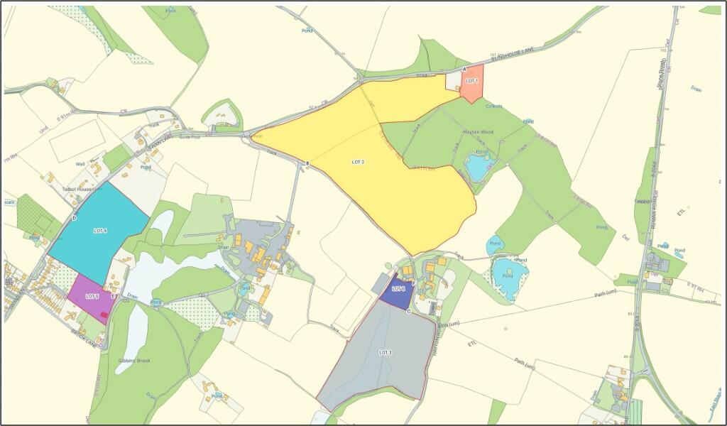
Photo 1 Photo 2 Photo 3 Photo 4
/ 4
Property details
Floor area
112 m²
EPC rating
E
Year built
England and Wales: 1967-1975
Last sold
£356,000 Nov 2020
Price per m²
£2,634/m²
Local average
£467,700 (-36.9%)
Deprivation
Decile 4 (12,380 of 33,755)
Street crime
3 incidents within 1 mile (Apr 2026)
Description
A parcel of agricultural land, classified as Grade III on the Agricultural Land Classification Plan for England and Wales. The soils are defined by the Soilscapes Map as "slowly permeable seasonally wet slightly acid but base-rich loamy and clayey soils". The land is split between 14.71 acres of permanent pasture to the north and 21.02 acres of arable land to the south. The arable land has been occupied under a rolling Farm Business Tenancy with vacant possession now available on completion. The 2023 arable cropping was Winter Wheat and the 2022 crop was Oil Seed . The land has been left as stubble and FYM has been spread in September 2023. It has a southerly aspect and has the potential to be planted with vines. The land is accessed from Hayton Road through a gated access. A public footpath crosses this parcel from the northern boundary to the western boundary.
FOR SALE BY INFORMAL TENDER - CLOSING MARCH 8TH 2024
Listed by
Heathfield
BTF Partnership LLP
Reference: 144216929
EPC Rating & Upgrade Cost
Current rating: E
Potential rating: C
Inspection date: 23/03/2020
Expiry date: 22/03/2030
Current heating cost: £946/year
Potential heating cost: £700/year
Recommendations
- Room-in-roof insulation (2,700)
- Floor insulation (solid floor) (6,000)
- Solar water heating (6,000)
- Solar photovoltaic panels, 2.5 kWp (5,500)
Flood risk
Zone: 1
Risk: Low
Job (default Low)
FENSA Certificates
This property has 2 FENSA certificate(s) on record, indicating window/door installations by FENSA-approved installers.
FENSA Certificate #5531953
Property Details
Street: 10 Swan Lane
Town: Sellindge
Postcode: TN25 6EP
Installation Details
Items: 13 windows
Certificate Issued: 10/03/2008
Work Completed: 09/01/2008
This certificate data was retrieved from FENSA's database
FENSA Certificate #1431747
Property Details
Street: 10 Swan Lane
Town: Sellindge
Postcode: TN25 6EP
Installation Details
Items: 1 door
Certificate Issued: 27/01/2004
Work Completed: 26/07/2003
This certificate data was retrieved from FENSA's database
What is FENSA? FENSA (Fenestration Self-Assessment Scheme) is a government-authorised scheme that monitors building regulation compliance for replacement windows and doors. Certificates indicate that work was completed by FENSA-approved installers.
Price history
| Event | Date | Price | % change |
|---|---|---|---|
| Sold | 25/11/2020 (5 years ago) | £356,000 | — |
Source: HM Land Registry Price Paid Data. Crown copyright.
Sold Comparables
Same street and nearby sales within 0.25 miles (last 5 years). Data from Land Registry Price Paid.
| Address | Price | Date | Type |
|---|---|---|---|
| Same street 5 SWAN LANE, SELLINDGE, ASHFORD, FOLKESTONE AND HYTHE, KENT, TN25 6EP | £380,000 | 17/11/2023 | Semi-detached |
| NORWEST HOLST-CRISPIN & BOARST STANFORD INTERSECTION, STANFORD, ASHFORD, FOLKESTONE AND HYTHE, KENT, TN25 6GH | £8,500,000 | 19/12/2022 | Other |
| IVY COTTAGE, 60 SWAN LANE, SELLINDGE, ASHFORD, FOLKESTONE AND HYTHE, KENT, TN25 6HB | £400,000 | 09/05/2022 | Other |
| Same street 11 SWAN LANE, SELLINDGE, ASHFORD, FOLKESTONE AND HYTHE, KENT, TN25 6EP | £405,000 | 24/09/2021 | Semi-detached |
Street average: £392,500 (2 sales)
Area average: £4,450,000 (2 sales)
Capital growth trend
Land Registry outcode average: last 12 months vs 5y and 10y ago (from sold prices).
House Price Index (HM Land Registry — official index, not sold-price averages): Folkestone and Hythe. Series: All dwelling types. As of March 2026.
Rental Range
Estimated market rent for Folkestone and Hythe. Low = conservative, Realistic = average, Optimistic = best case.
Based on Local Authority from postcode lookup → Folkestone and Hythe.
LHA (30th percentile) floor for Ashford: Apr 2025 – Mar 2026
Location
Nearby
Nearest stations, universities and amenities (distance from property).
| Type | Name | Distance |
|---|---|---|
| Bus stop | Downs Way | 0.0 miles |
| Shop | Sellindge Premier | 0.1 miles |
| Train station | Westenhanger | 1.5 miles |
| Shop | WHSmith | 1.8 miles |
| Train station | Sandling | 2.8 miles |
| Hospital | William Harvey Hospital (Ashford) | 4.6 miles |
| Hospital | WIlliam Harvey Hospital | 4.7 miles |
Street-level crime
| Category | Count |
|---|---|
| Violence and sexual offences | 2 |
| Anti-social behaviour | 1 |
| Total incidents | 3 |
Within 1 mile during Apr 2026. Source: data.police.uk (England & Wales).
Schools nearby
Nearest open schools with Ofsted ratings (England). Closed schools are not shown. Data from Get Information about Schools and Ofsted.
| Name | Type | Distance | Ofsted |
|---|---|---|---|
| Sellindge Primary School | Primary | 0.2 miles | Good — 16 Mar 2023 |
| Lympne Church of England Primary School | Primary | 2.1 miles | Good — 18 Apr 2012 |
| Smeeth Community Primary School | Primary | 2.1 miles | Good — 14 Sep 2023 |
| Brabourne Church of England Primary School | Primary | 2.4 miles | Good — 11 Nov 2013 |
| Caldecott Foundation School | Other | 2.5 miles | Good — 5 Apr 2017 |
Rental Comparables
Loading rental comparables for this postcode. Refresh in a few minutes.
Rent-driven metrics
Based on Area rent estimate.
- Rent ratio — Monthly rent ÷ purchase price (1% rule). 1%+ = strong, 0.8–1% = okay, <0.8% = weak for cashflow.
- Max investor price — Rent ÷ 0.8%; the price at which rent would be 0.8% of price (Stoke-style target).
- Target investor price — Rent ÷ 1%; the price at which rent would be 1% of price (strong cashflow band).
- Gross yield — Annual rent as % of purchase price (no costs).