51 ELM GROVE
SUTTON, SUTTON, GREATER LONDON SM1 4EX
£725 pcm
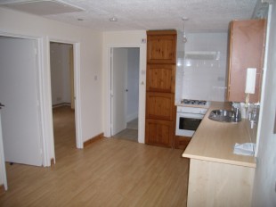
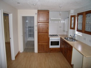
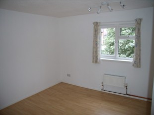
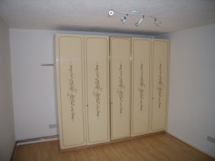
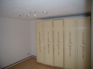
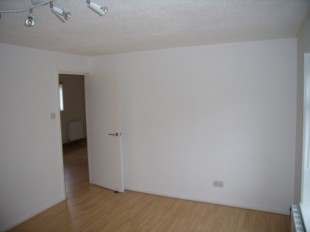
Photo 1 Photo 2 Photo 3 Photo 4 Photo 5 Photo 6
/ 6
Property details
Floor area
46 m²
EPC rating
C
Year built
England and Wales: 1983-1990
Deprivation
Decile 3 (7,399 of 33,755)
Street crime
488 incidents within 1 mile (Apr 2026)
Description
Listed by
Sutton - Lettings
Frost Brothers
Reference: 7613448
EPC Rating & Upgrade Cost
Current rating: C
Potential rating: C
Inspection date: 11/05/2024
Expiry date: 10/05/2034
Current heating cost: £439/year
Potential heating cost: £439/year
Flood risk
Zone: 1
Risk: Low
Job (default Low)
FENSA Certificates
This property has 2 FENSA certificate(s) on record, indicating window/door installations by FENSA-approved installers.
FENSA Certificate #2035053
Property Details
Street: 51 Elm Grove
Town: Sutton
Postcode: SM1 4EX
Installation Details
Items: 5 windows
Certificate Issued: 13/09/2004
Work Completed: 20/08/2004
This certificate data was retrieved from FENSA's database
FENSA Certificate #11750914
Property Details
Street: 51 Elm Grove
Town: SUTTON
Postcode: SM1 4EX
Installation Details
Items: 1 door
Certificate Issued: 25/07/2016
Work Completed: 05/05/2016
This certificate data was retrieved from FENSA's database
What is FENSA? FENSA (Fenestration Self-Assessment Scheme) is a government-authorised scheme that monitors building regulation compliance for replacement windows and doors. Certificates indicate that work was completed by FENSA-approved installers.
Rental Range
Estimated market rent for Sutton. Low = conservative, Realistic = average, Optimistic = best case.
Based on Local Authority from postcode lookup → Sutton.
LHA (30th percentile) floor for Outer South London: £1,197/mo (Apr 2025 – Mar 2026)
Location
Nearby
Nearest stations, universities and amenities (distance from property).
| Type | Name | Distance |
|---|---|---|
| Bus stop | Benhill Avenue | 0.0 miles |
| Shop | Princess Alice Hospice | 0.0 miles |
| Shop | H&T Pawnbrokers | 0.0 miles |
| Bus stop | Sutton / Marshall's Road | 0.1 miles |
| Train station | West Sutton | 0.5 miles |
| Train station | Sutton | 0.5 miles |
| Hospital | Queen Mary's Childrens' Hospital | 1.0 miles |
| Hospital | Chapel Orchard Day Surgery | 2.6 miles |
| University | Horton Halls Reception | 4.8 miles |
| University | BIMM Institute London | 7.8 miles |
Street-level crime
| Category | Count |
|---|---|
| Violence and sexual offences | 146 |
| Anti-social behaviour | 120 |
| Vehicle crime | 45 |
| Other theft | 35 |
| Public order | 33 |
| Criminal damage and arson | 30 |
| Shoplifting | 24 |
| Drugs | 17 |
| Burglary | 15 |
| Other crime | 7 |
| Robbery | 5 |
| Bicycle theft | 4 |
| Theft from the person | 4 |
| Possession of weapons | 3 |
| Total incidents | 488 |
Within 1 mile during Apr 2026. Source: data.police.uk (England & Wales).
Schools nearby
Nearest open schools with Ofsted ratings (England). Closed schools are not shown. Data from Get Information about Schools and Ofsted.
| Name | Type | Distance | Ofsted |
|---|---|---|---|
| Robin Hood Junior School | Primary | 0.2 miles | Good — 30 Oct 2012 |
| Sutton Grammar School | Secondary | 0.2 miles | Good — 21 Sep 2022 |
| Manor Park Primary Academy | Primary | 0.3 miles | Outstanding — 8 Jun 2015 |
| The Limes College | Other | 0.4 miles | Good — 15 Jan 2024 |
| All Saints Benhilton CofE Primary School | Primary | 0.4 miles | Good — 4 Sep 2015 |
Rental Comparables
Residential lets from OpenRent and Rightmove for the area (same bedroom count). Use to validate rent estimates. Student lets are excluded.
| Title | Rent | Beds | Distance | As seen on |
|---|---|---|---|---|
| 2 Bed Flat, Gateway Court, SM1 | £1,750/mo | 2 | 0.26 miles | OpenRent |
| 2 Bed Terraced House, Collingwood Road, SM1 | £1,850/mo | 2 | 0.42 miles | OpenRent |
Average rent: £1,800/mo (2 listings)