Land @ Harington Drive
Stoke-On-Trent, Staffordshire ST3 5SX
Listing type
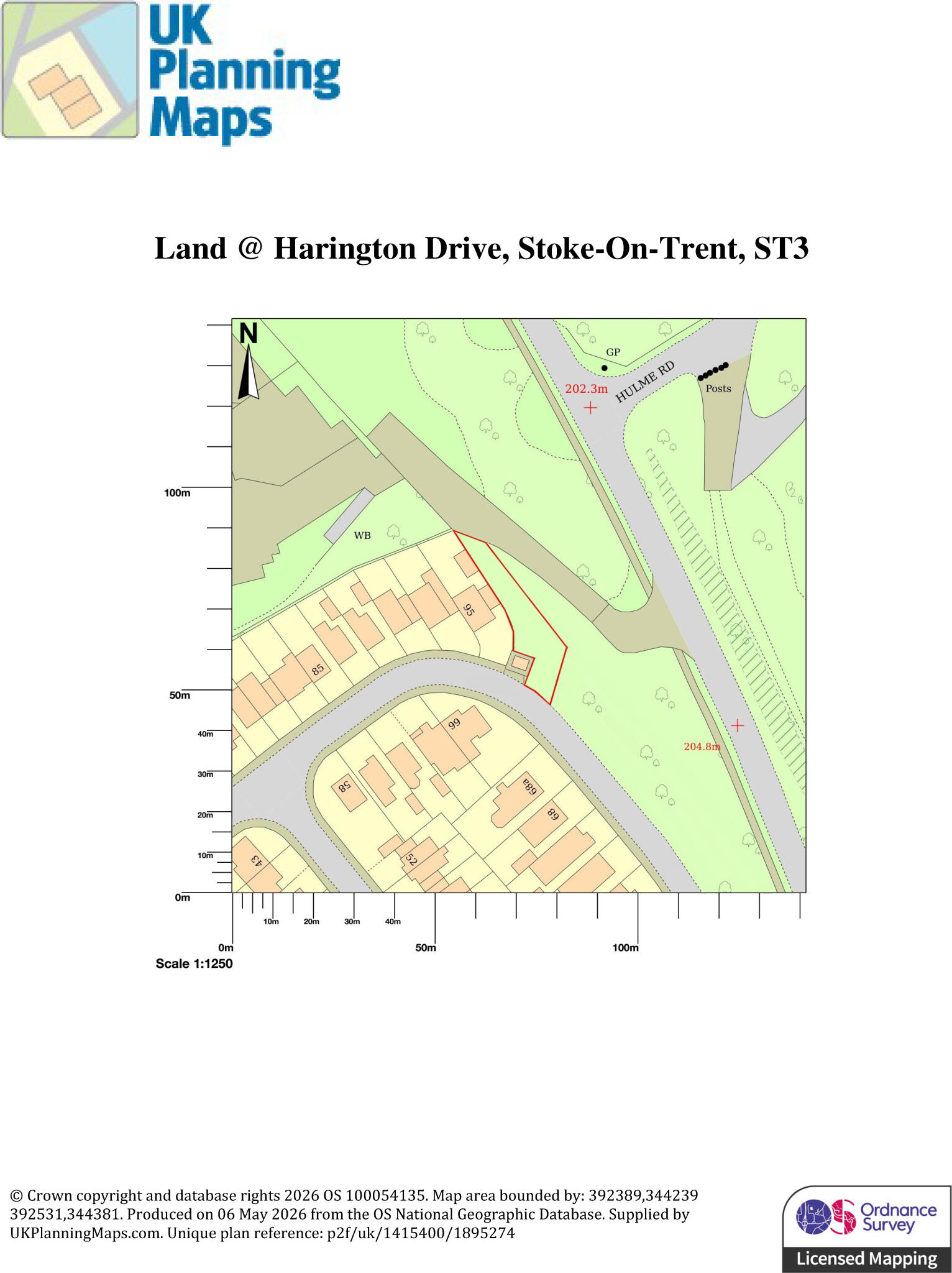
B. Satellite Plot HD 1 T202605291347.jpg D. Site Comparable Measures T202605291346.jpg C. Plot Roadside Measurement T202605291347.jpg A. Plot Satellite Map 1 T202605291347.jpg C. Plot Roadside T202605291346.jpg D. Site Comparables T202605291346.jpg A. Plot OS Map 1 T202605291346.jpg B. Satellite Plot 1 T202605291347.jpg
/ 8
Property details
Listing category
Auction
Tenure
FREEHOLD
Last sold
£37,000
Local average
£302,333 (-97.7%)
Deprivation
Decile 8 (25,665 of 33,755)
Street crime
228 incidents within 1 mile (Mar 2026)
Key features
- FOR SALE VIA ONLINE AUCTION ON MONDAY 29th June AT 1PM UNTIL TUESDAY 30th June 1PM.
- LAND FOR SALE IN STOKE
- LAND AVAILABLE TO VISIT ANYTIME
- BUYER'S FEES APPLY (PLEASE READ LEGAL PACK)
- GUIDE PRICE £7,000 - £14,000
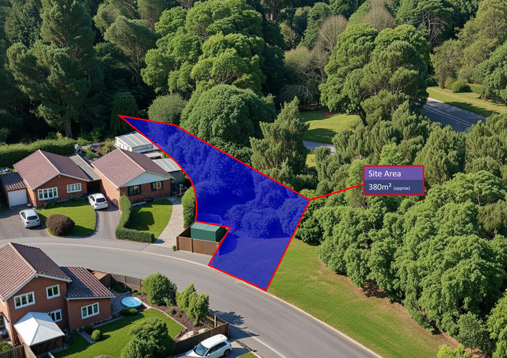
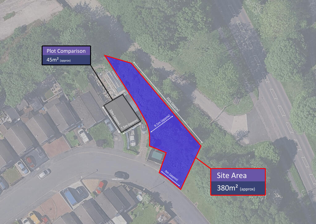
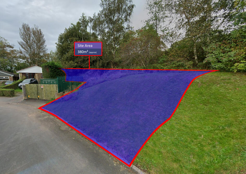
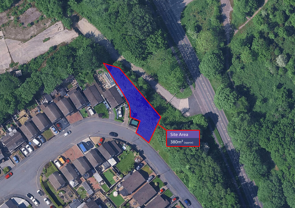
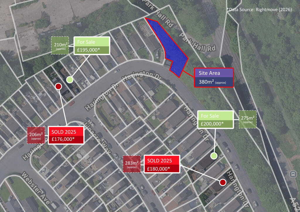
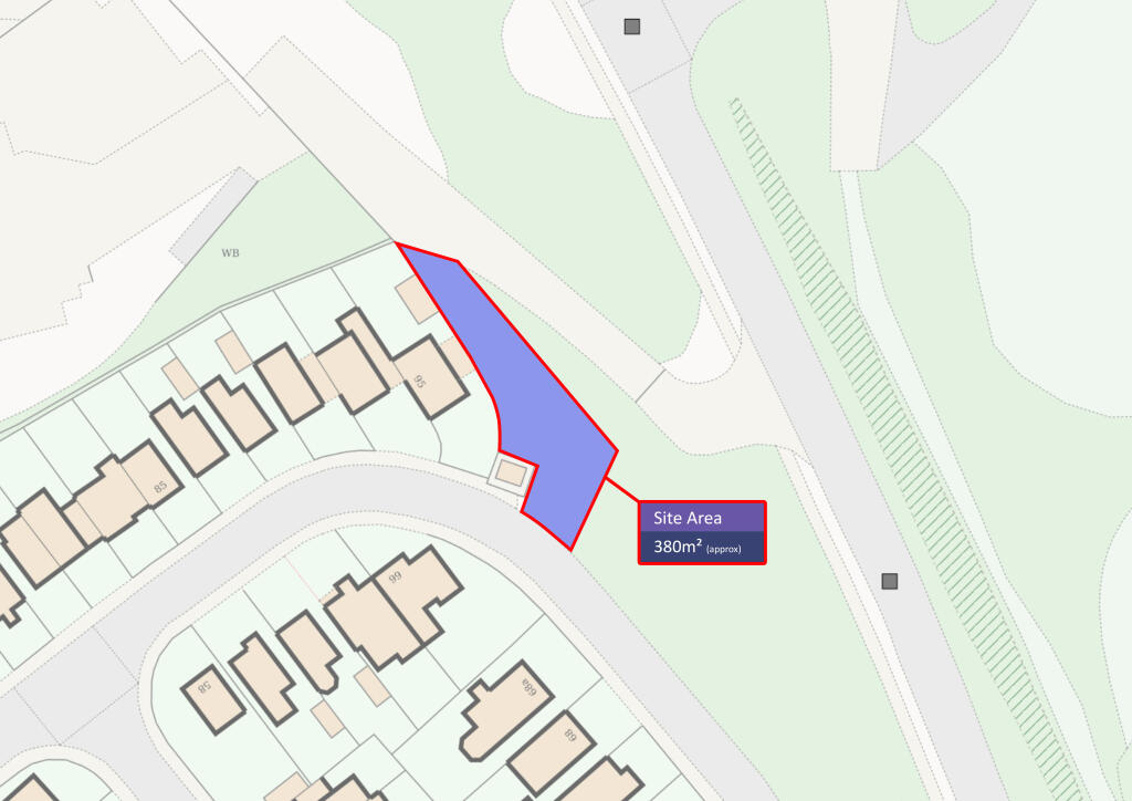
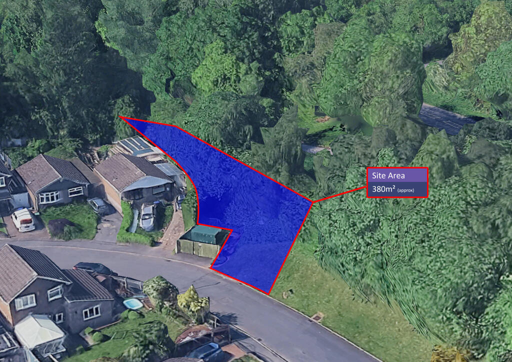
- APPROX. 380m² TOTAL AREA
- DESIRABLE LOCATION
Additional details
- Parking
- Yes
Description
FOR SALE VIA ONLINE AUCTION ON MONDAY 29th June AT 1PM UNTIL TUESDAY 30th June 1PM.
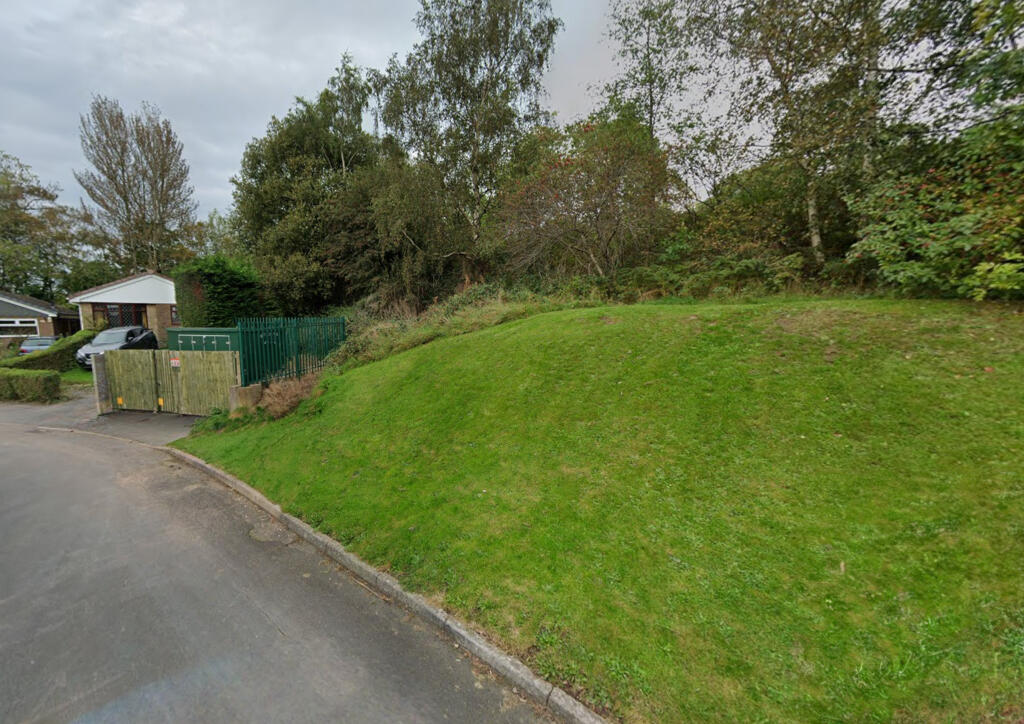
Current Vacant plot situated in the highly coveted location of Weston Coyney . In one of Stoke on Trent's most sought after neighbourhoods.
AUCTION HOUSE have not visited or inspected the land.
Purchasers are deemed to rely on their own enquiries with regard to any possible development potential for this individual plot in respect of planning and any other consents or rights over the land including adopted highways, public right of ways etc.
Land @ Harington Drive, Stoke-On-Trent, ST3
APPROX. 380m² TOTAL AREA
1.{tab}Investment potential
2.{tab}Excellent prospect
3.{tab}Safe affluential secure area
Excellent central motorway access
Strong national rail connectivity
Good access to multiple major airports
Strong logistics and industrial positioning
Tenure: Freehold
Administration Fee: £1500 inc VAT payable on exchange of contracts.
Buyer's Premium Fee: £900 inc VAT payable on exchange of contracts.
Disbursements: Please see the legal pack for any disbursements listed that may become payable by the purchaser on completion.
Listed by
Covering Cheshire, Staffordshire & Shropshire
Auction House (UK) Limited
Reference: 89097207
EPC ratings on this postcode
We don't have a matched EPC for this property yet. Below are efficiency scores and details for other addresses on this postcode.
| Address | Current | Potential | Floor area | Age band | Type |
|---|---|---|---|---|---|
| 1 Webster Avenue, STOKE-ON-TRENT | 72 | 85 | 100 m² | England and Wales: 1976-1982 | Detached |
| 13, Webster Avenue, STOKE-ON-TRENT | 65 | 80 | 79 m² | — | Detached |
| 16, Webster Avenue, STOKE-ON-TRENT | 65 | 80 | 78 m² | — | Detached |
| 17, Webster Avenue, STOKE-ON-TRENT | 69 | 86 | 71 m² | England and Wales: 1976-1982 | Detached |
| 18, Webster Avenue, STOKE-ON-TRENT | 69 | 87 | 65 m² | England and Wales: 1967-1975 | Detached |
| 19, Webster Avenue, STOKE-ON-TRENT | 69 | 89 | 71 m² | England and Wales: 1983-1990 | Detached |
| 2 Webster Avenue, STOKE-ON-TRENT | 67 | 85 | 64 m² | England and Wales: 1967-1975 | Detached |
| 21, Webster Avenue, STOKE-ON-TRENT | 65 | 80 | 78 m² | England and Wales: 1967-1975 | Detached |
| 22, Webster Avenue, STOKE-ON-TRENT | 58 | 84 | 66 m² | England and Wales: 1976-1982 | Detached |
| 23 Webster Avenue, STOKE-ON-TRENT | 69 | 77 | 89 m² | England and Wales: 1976-1982 | Detached |
| 25, Webster Avenue, STOKE-ON-TRENT | 65 | 84 | 69 m² | England and Wales: 1976-1982 | Detached |
| 27, Webster Avenue, STOKE-ON-TRENT | 68 | 84 | 74 m² | England and Wales: 1976-1982 | Detached |
| 28, Webster Avenue, STOKE-ON-TRENT | 63 | 80 | 72 m² | — | Detached |
| 40 Webster Avenue, STOKE-ON-TRENT | 70 | 77 | 63 m² | England and Wales: 1967-1975 | Detached |
| 40, Webster Avenue, STOKE-ON-TRENT | 50 | 79 | 65 m² | England and Wales: 1967-1975 | Detached |
Flood risk
Zone: 1
Risk: Low
Job (default Low)
Floorplans
TP1 JPG T202605291349.jpg
Price history
| Event | Date | Price | % change |
|---|---|---|---|
| Listed for sale | — | £7,000 | -81.1% |
| Sold | 01/01/1996 (30 years ago) | £37,000 | — |
Source: HM Land Registry Price Paid Data. Crown copyright.
Sold Comparables
Same street and nearby sales within 0.25 miles (last 5 years). Data from Land Registry Price Paid.
| Address | Price | Date | Type |
|---|---|---|---|
| 63 DEANSCROFT WAY, STOKE-ON-TRENT, ST3 5XW | £175,000 | 17/03/2022 | Other |
Area average: £175,000 (1 sale)
Capital growth trend
Land Registry outcode average: last 12 months vs 5y and 10y ago (from sold prices).
House Price Index (HM Land Registry — official index, not sold-price averages): Stoke-on-Trent. Series: All dwelling types. As of March 2026.
Rental Range
Estimated market rent for Stoke-on-Trent. Low = conservative, Realistic = average, Optimistic = best case.
Based on Local Authority from postcode lookup → Stoke-on-Trent.
LHA (30th percentile) floor for Staffordshire North: Apr 2025 – Mar 2026
Location
Address
Webster Avenue
Nearby
Nearest stations, universities and amenities (distance from property).
| Type | Name | Distance |
|---|---|---|
| Shop | Tesco Express | 0.3 miles |
| Bus stop | Unknown | 0.4 miles |
| Bus stop | Mossfield Road | 0.4 miles |
| Shop | Bluebells | 0.5 miles |
| Train station | Longton | 1.0 miles |
| Train station | Caverswall Road | 2.5 miles |
| Hospital | Royal Stoke University Hospital | 4.2 miles |
| Hospital | North Staffordshire Nuffield Hospital | 4.5 miles |
| University | Keele University | 6.5 miles |
| University | Buxton & Leek College | 8.7 miles |
Street-level crime
| Category | Count |
|---|---|
| Violence and sexual offences | 80 |
| Anti-social behaviour | 35 |
| Public order | 26 |
| Criminal damage and arson | 17 |
| Shoplifting | 14 |
| Other theft | 13 |
| Burglary | 11 |
| Drugs | 10 |
| Vehicle crime | 7 |
| Other crime | 5 |
| Robbery | 5 |
| Bicycle theft | 3 |
| Possession of weapons | 2 |
| Total incidents | 228 |
Within 1 mile during Mar 2026. Source: data.police.uk (England & Wales).
Schools nearby
Nearest open schools with Ofsted ratings (England). Closed schools are not shown. Data from Get Information about Schools and Ofsted.
| Name | Type | Distance | Ofsted |
|---|---|---|---|
| Park Hall Academy | Primary | 0.6 miles | Good — 9 Feb 2011 |
| Gladstone Primary Academy | Primary | 0.6 miles | Good — 18 Apr 2013 |
| Sandford Hill Primary School | Primary | 0.8 miles | Good — 15 Nov 2023 |
| Weston Junior Academy | Primary | 0.8 miles | Good — 26 May 2022 |
| Discovery Academy | Secondary | 0.9 miles | Requires improvement — 13 May 2024 |
Rental Comparables
Residential lets from OpenRent and Rightmove for the area. Bedroom counts vary — use the Beds column to compare like-for-like lets. Student lets are excluded.
Average rent: £802/mo (25 listings)
Rent-driven metrics
Based on OpenRent comparables.
- Rent ratio — Monthly rent ÷ purchase price (1% rule). 1%+ = strong, 0.8–1% = okay, <0.8% = weak for cashflow.
- Max investor price — Rent ÷ 0.8%; the price at which rent would be 0.8% of price (Stoke-style target).
- Target investor price — Rent ÷ 1%; the price at which rent would be 1% of price (strong cashflow band).
- Gross yield — Annual rent as % of purchase price (no costs).
- Cost-to-rent — Price ÷ annual rent (from OpenRent comparables). Under 14× = strong, 14–16× = acceptable, 17×+ = compressed.
- Cashflow — Rent minus mortgage, 10% maintenance, £25/mo compliance. Assumes 75% LTV, 3.95% APR (5yr fixed), 25yr term.
- ROI — Annual profit ÷ cash in (deposit + 4% purchase costs).
Enter House Number
Enter the house number to help us retrieve more accurate pricing history and property data.
Please log in to submit or correct the house number for this listing.
Log in to continue