4A
CHURCH FARM BARNS, THE STREET, NORWICH, BRAMERTON, NORFOLK NR14 7DW
£250,000
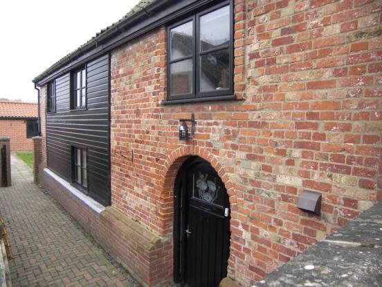
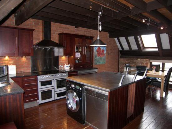
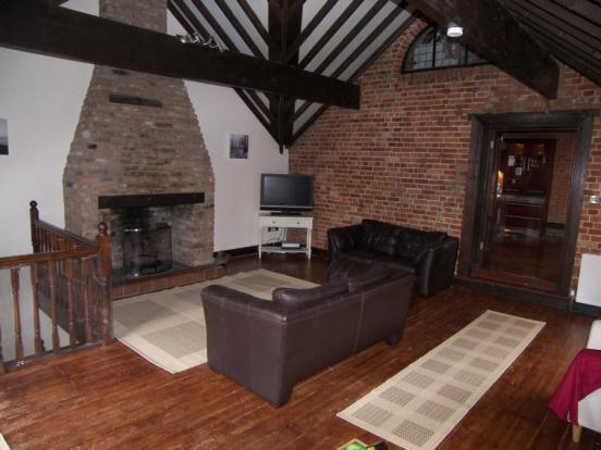
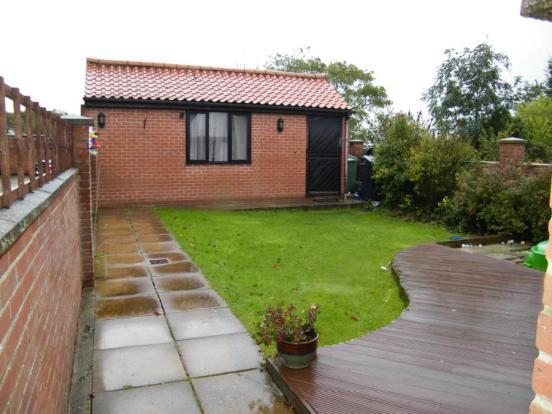
Photo 1 Photo 2 Photo 3 Photo 4 EPC
/ 5
Property details
Last sold
£232,500 Feb 2011
Local average
£726,438 (-65.6%)
Deprivation
Decile 8 (23,694 of 33,755)
Street crime
0 incidents within 1 mile (Apr 2026)
Additional details
- Parking
- Yes
- Garden
- Yes
Description
3 Bedrooms
Study
Detached Garage
Enclosed Garden with Decking
En-suite to Master
Village Location
A fine example of rural village living, this superb barn conversion is found in the highly sought after village of Bramerton, which lies within six miles south east of Norwich City centre. This charming barn conversion packed with features including vaulted beamed ceilings, exposed wood flooring and brick open fire place. The property combines rustic charm with a contemporary feel. Accommodation includes on the ground floor: hall, three bedrooms with master en-suite, first floor: 20' x 20' lounge, 20' kitchen/dining room and second floor: bedroom four/study. It's thought that this property will command strong interest and we would recommend immediate internal viewing to avoid disappointment.
Agents Note. Pursuant to Section 21 of the Estate Agents Act, we hereby advise all interested parties that the vendor of this property is an employee of Abbotts Countrywide.
Listed by
Norwich
Countrywide UK Sales - Connells
Reference: 32343200
Flood risk
Zone: 1
Risk: Low
Job (default Low)
Floorplans
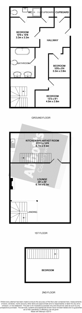
Floorplan 1
FENSA Certificates
This property has 1 FENSA certificate(s) on record, indicating window/door installations by FENSA-approved installers.
FENSA Certificate #16178709 Recent
Property Details
Street: 4a Church Farm Barns
Town: The Street
Postcode: NR14 7DW
Installation Details
Items: 10 windows
Certificate Issued: 25/02/2024
Work Completed: 16/01/2024
This certificate data was retrieved from FENSA's database
What is FENSA? FENSA (Fenestration Self-Assessment Scheme) is a government-authorised scheme that monitors building regulation compliance for replacement windows and doors. Certificates indicate that work was completed by FENSA-approved installers.
Price history
55% since 2001
| Event | Date | Price | % change |
|---|---|---|---|
| Sold | 01/02/2011 (15 years ago) | £232,500 | -25% |
| Sold | 09/11/2006 (19 years ago) | £310,000 | +106.7% |
| Sold | 01/03/2001 (25 years ago) | £150,000 | — |
Source: HM Land Registry Price Paid Data. Crown copyright.
Sold Comparables
Same street and nearby sales within 0.25 miles (last 5 years). Data from Land Registry Price Paid.
| Address | Price | Date | Type |
|---|---|---|---|
| 3A CHURCH FARM CLOSE, BRAMERTON, NORWICH, SOUTH NORFOLK, NORFOLK, NR14 7FD | £650,000 | 15/12/2022 | Other |
| 3A CHURCH FARM CLOSE, BRAMERTON, NORWICH, SOUTH NORFOLK, NORFOLK, NR14 7FD | £180,000 | 30/05/2022 | Other |
Area average: £415,000 (2 sales)
Capital growth trend
Land Registry outcode average: last 12 months vs 5y and 10y ago (from sold prices).
House Price Index (HM Land Registry — official index, not sold-price averages): South Norfolk. Series: All dwelling types. As of March 2026.
Rental Range
Estimated market rent for South Norfolk. Low = conservative, Realistic = average, Optimistic = best case.
Based on Local Authority from postcode lookup → South Norfolk.
LHA (30th percentile) floor for Central Norfolk & Norwich: £1,147/mo (Apr 2025 – Mar 2026)
Location
Address
Bramerton, South Norfolk, Norfolk, England, NR14 7DW, United Kingdom
Nearby
Nearest stations, universities and amenities (distance from property).
| Type | Name | Distance |
|---|---|---|
| Bus stop | Rockland Road, adj | 0.1 miles |
| Bus stop | Hall, adj | 0.2 miles |
| Shop | Applebee Orchard and Apiary | 0.5 miles |
| Shop | Yelverton Garage | 1.0 miles |
| Train station | Brundall Gardens | 2.5 miles |
| Train station | Brundall | 2.9 miles |
| University | Broadcast House | 4.9 miles |
| Hospital | Norfolk and Norwich University Hospital:Emergency Department | 7.3 miles |
| University | Easton College | 10.3 miles |
Street-level crime
| Category | Count |
|---|---|
| Total incidents | 0 |
Within 1 mile during Apr 2026. Source: data.police.uk (England & Wales).
Schools nearby
Nearest open schools with Ofsted ratings (England). Closed schools are not shown. Data from Get Information about Schools and Ofsted.
| Name | Type | Distance | Ofsted |
|---|---|---|---|
| Rockland St Mary Primary School | Primary | 1.2 miles | Good — 15 Mar 2022 |
| Surlingham Primary School | Primary | 1.5 miles | Good — 20 Mar 2022 |
| Alpington and Bergh Apton Church of England Voluntary Aided Primary School | Primary | 1.8 miles | Outstanding — 9 Sep 2015 |
| Poringland Primary School | Primary | 2.2 miles | Good — 6 Jul 2023 |
| Framingham Earl High School | Secondary | 2.3 miles | Good — 6 Nov 2014 |
Rental Comparables
Loading rental comparables for this postcode. Refresh in a few minutes.
Rent-driven metrics
Based on Area rent estimate.
- Rent ratio — Monthly rent ÷ purchase price (1% rule). 1%+ = strong, 0.8–1% = okay, <0.8% = weak for cashflow.
- Max investor price — Rent ÷ 0.8%; the price at which rent would be 0.8% of price (Stoke-style target).
- Target investor price — Rent ÷ 1%; the price at which rent would be 1% of price (strong cashflow band).
- Gross yield — Annual rent as % of purchase price (no costs).