70 MAXWELL ROAD
BEACONSFIELD, BEACONSFIELD, BUCKINGHAMSHIRE HP9 1QZ
£1,175 pcm
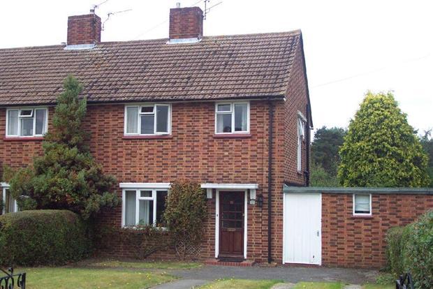

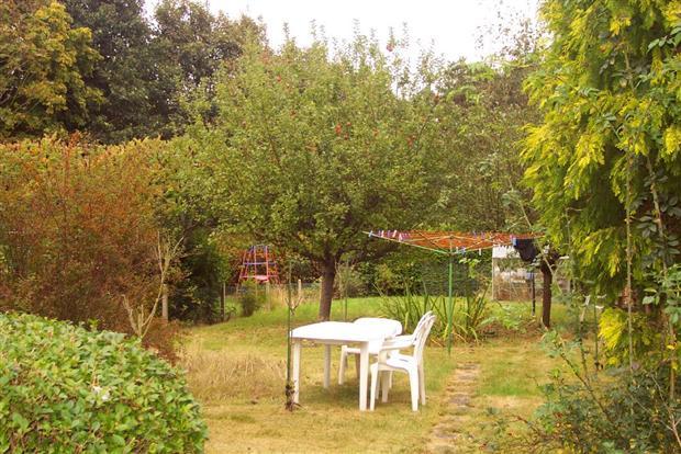
Photo 1 Photo 2 Photo 3
/ 3
Property details
Floor area
84 m²
Deprivation
Decile 8 (26,660 of 33,755)
Street crime
63 incidents within 1 mile (Apr 2026)
Additional details
- Parking
- Yes
- Garden
- Yes
Description
the property benefits from having two double bedrooms with built in storage and a good size single bedroom, the family bathroom has a three piece white bathroom suite and also a shower over the bath finished with white tiling, with two reception rooms and a good size fully integrated kitchen the property boasts a wealth of benefits and would be fantastic for a family or shareres alike.
With front and rear gardens that are well matured and so the maintenance is easy the outdoor space is very good with outdoor secure storage shed and off street parking for two cars.
the property is decorated neutrally throughout and can be offered furnished or unfurnished and is available immediatly.
Viewings are a must and be quick as this one will go!!!!
Listed by
Greenford - Lettings
Spicerhaart Lettings
Reference: 28000975
EPC Rating & Upgrade Cost
Fetching EPC data… Refresh this page in a moment.
Flood risk
Zone: 1
Risk: Low
Job (default Low)
Rental Range
Estimated market rent for Buckinghamshire. Low = conservative, Realistic = average, Optimistic = best case.
Based on Local Authority from postcode lookup → Buckinghamshire.
LHA (30th percentile) floor for Milton Keynes: £1,192/mo (Apr 2025 – Mar 2026)
Location
Nearby
Nearest stations, universities and amenities (distance from property).
| Type | Name | Distance |
|---|---|---|
| Bus stop | Waller Road | 0.1 miles |
| Shop | Timpson | 0.3 miles |
| Shop | Sainsbury's | 0.3 miles |
| Train station | Beaconsfield | 0.3 miles |
| University | National Film and Television School | 0.4 miles |
| Train station | Seer Green and Jordans | 1.2 miles |
| Hospital | Amersham Hospital | 3.6 miles |
| Hospital | Chalfont Centre for Epilepsy | 3.8 miles |
| University | Buckinghamshire New University | 4.9 miles |
Street-level crime
| Category | Count |
|---|---|
| Shoplifting | 13 |
| Violence and sexual offences | 13 |
| Vehicle crime | 11 |
| Criminal damage and arson | 9 |
| Public order | 6 |
| Anti-social behaviour | 3 |
| Burglary | 3 |
| Other theft | 2 |
| Other crime | 1 |
| Possession of weapons | 1 |
| Theft from the person | 1 |
| Total incidents | 63 |
Within 1 mile during Apr 2026. Source: data.police.uk (England & Wales).
Schools nearby
Nearest open schools with Ofsted ratings (England). Closed schools are not shown. Data from Get Information about Schools and Ofsted.
| Name | Type | Distance | Ofsted |
|---|---|---|---|
| St Mary and All Saints CofE Primary School | Primary | 0.1 miles | Requires improvement — 21 Sep 2022 |
| Davenies School | Other | 0.3 miles | — (No rating) |
| High March School | Other | 0.5 miles | — (No rating) |
| Butlers Court School | Primary | 0.5 miles | Good — 6 Nov 2013 |
| The Beaconsfield School | Secondary | 0.6 miles | Good — 10 Mar 2019 |
Rental Comparables
Residential lets from OpenRent and Rightmove for the area (same bedroom count). Use to validate rent estimates. Student lets are excluded.
| Title | Rent | Beds | Distance | As seen on |
|---|---|---|---|---|
| 3 Bed Bungalow, Brownswood Road, HP9 | £3,300/mo | 3 | 0.63 miles | OpenRent |
Average rent: £3,300/mo (1 listing)