Apartment 11
THE ROWANS, HAMPTON COURT WAY, WIDNES, HALTON WA8 3EA
£130,000
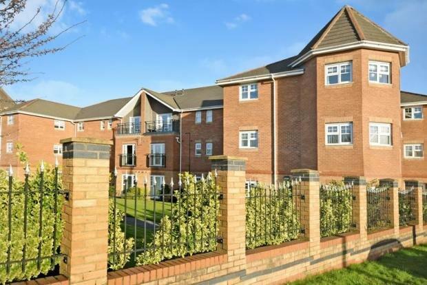

Photo 1 Photo 2
/ 2
Property details
Tenure
LEASEHOLD
Floor area
61 m²
Council tax band
B
Last sold
£126,500 Mar 2023
Local average
£96,045 (+35.4%)
Deprivation
Decile 10 (31,695 of 33,755)
Street crime
85 incidents within 1 mile (Apr 2026)
Key features
- Two Bed Apartment
- Larger Format
- Balcony Terrace
- Modern Interior
- Allocated Parking
- No Onward Chain
- Top Floor
- Largest Format Two Bed
- En-Suite to Master
Additional details
- Heating
- Gas
- Parking
- Yes
Description
Features include entrance hall, spacious lounge, modern fitted kitchen, two bedrooms with en-suite facilities to master and family bathroom. Allocated parking, secure entry system and communal gardens. New Photo's and Full Details will follow.
Listed by
Widnes
Adams Sales Limited
Reference: 127962035
EPC ratings on this postcode
We don't have a matched EPC for this property yet. Below are efficiency scores and details for other addresses on this postcode.
| Address | Current | Potential | Floor area | Age band | Type |
|---|---|---|---|---|---|
| Apartment 11 The Rowans, Hampton Court Way, WIDNES | 78 | 81 | 61 m² | England and Wales: 2003-2006 | Flat |
Flood risk
Zone: 1
Risk: Low
Job (default Low)
Floorplans
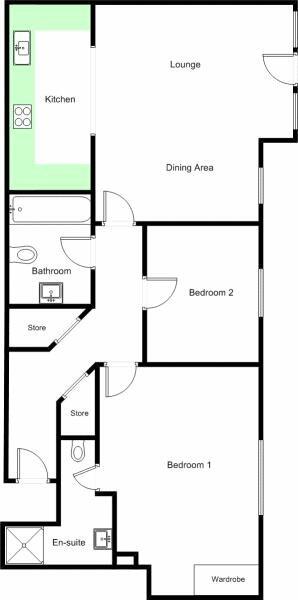
Floorplan 1
Price history
| Event | Date | Price | % change |
|---|---|---|---|
| Sold | 31/03/2023 (3 years ago) | £126,500 | — |
Source: HM Land Registry Price Paid Data. Crown copyright.
Sold Comparables
Same street and nearby sales within 0.25 miles (last 5 years). Data from Land Registry Price Paid.
| Address | Price | Date | Type |
|---|---|---|---|
| 11 LATIMER CLOSE, WIDNES, HALTON, WA8 9NR | £95,000 | 28/11/2025 | Flat |
| 7 RIVENMILL CLOSE, WIDNES, HALTON, WA8 3FJ | £130,000 | 09/11/2023 | Flat |
| THE BEECHES APARTMENT 9 HAMPTON COURT WAY, WIDNES, HALTON, WA8 3EB | £114,000 | 31/08/2022 | Flat |
| Same street THE ROWANS APARTMENT 4 HAMPTON COURT WAY, WIDNES, HALTON, WA8 3EA | £120,000 | 22/08/2022 | Flat |
| 18 LATIMER CLOSE, WIDNES, HALTON, WA8 9NR | £77,000 | 27/07/2022 | Flat |
| 19 RIVENMILL CLOSE, WIDNES, HALTON, WA8 3FJ | £100,000 | 04/02/2022 | Flat |
| 4 RICHMOND COURT, WIDNES, HALTON, WA8 3HA | £103,000 | 16/12/2021 | Flat |
| 9 RICHMOND COURT, WIDNES, HALTON, WA8 3HA | £105,000 | 07/12/2021 | Flat |
| 15 RIVENMILL CLOSE, WIDNES, HALTON, WA8 3FJ | £66,000 | 30/06/2021 | Flat |
| THE PINES APARTMENT 6 HAMPTON COURT WAY, WIDNES, HALTON, WA8 3EF | £135,000 | 29/06/2021 | Flat |
Street average: £120,000 (1 sale)
Area average: £102,778 (9 sales)
Capital growth trend
Land Registry outcode average: last 12 months vs 5y and 10y ago (from sold prices).
House Price Index (HM Land Registry — official index, not sold-price averages): Halton. Series: Flats and maisonettes. As of March 2026.
Rental Range
Estimated market rent for Halton. Low = conservative, Realistic = average, Optimistic = best case.
Based on Local Authority from postcode lookup → Halton.
LHA (30th percentile) floor for North Cheshire: £588/mo (Apr 2025 – Mar 2026)
Location
Address
Mill Green, Widnes, Halton, Liverpool City Region, England, WA8 3EB, United Kingdom
Nearby
Nearest stations, universities and amenities (distance from property).
| Type | Name | Distance |
|---|---|---|
| Bus stop | Horns | 0.0 miles |
| Bus stop | Everglades Hotel | 0.1 miles |
| Shop | Motorpoint | 0.2 miles |
| Shop | Jewson | 0.2 miles |
| Train station | Widnes | 0.9 miles |
| Train station | Hough Green | 2.7 miles |
| Hospital | Elizabeth Court Care Centre | 3.2 miles |
| Hospital | St Helens Hospital | 3.7 miles |
| University | University of Chester - Warrington Campus | 7.2 miles |
| University | Liverpool Hope University | 7.3 miles |
Street-level crime
| Category | Count |
|---|---|
| Violence and sexual offences | 34 |
| Anti-social behaviour | 23 |
| Public order | 12 |
| Criminal damage and arson | 5 |
| Other theft | 3 |
| Burglary | 2 |
| Drugs | 2 |
| Vehicle crime | 2 |
| Other crime | 1 |
| Shoplifting | 1 |
| Total incidents | 85 |
Within 1 mile during Apr 2026. Source: data.police.uk (England & Wales).
Schools nearby
Nearest open schools with Ofsted ratings (England). Closed schools are not shown. Data from Get Information about Schools and Ofsted.
| Name | Type | Distance | Ofsted |
|---|---|---|---|
| Moorfield Primary School | Primary | 0.4 miles | Good — 4 Nov 2019 |
| Lunts Heath Primary School | Primary | 0.6 miles | — (Inspected (no overall grade)) |
| Farnworth Church of England Controlled Primary School | Primary | 0.7 miles | Good — 28 Sep 2023 |
| Brookfields School | Other | 0.7 miles | — (Inspected (no overall grade)) |
| Fairfield Primary School | Primary | 0.9 miles | Good — 3 Feb 2015 |
Rental Comparables
Loading rental comparables for this postcode. Refresh in a few minutes.
Rent-driven metrics
Based on Area rent estimate.
- Rent ratio — Monthly rent ÷ purchase price (1% rule). 1%+ = strong, 0.8–1% = okay, <0.8% = weak for cashflow.
- Max investor price — Rent ÷ 0.8%; the price at which rent would be 0.8% of price (Stoke-style target).
- Target investor price — Rent ÷ 1%; the price at which rent would be 1% of price (strong cashflow band).
- Gross yield — Annual rent as % of purchase price (no costs).
Enter House Number
Enter the house number to help us retrieve more accurate pricing history and property data.
Please log in to submit or correct the house number for this listing.
Log in to continue