118 WHITE HART LANE
ROMFORD, COLLIER ROW, GREATER LONDON RM7 8LX
£350,000
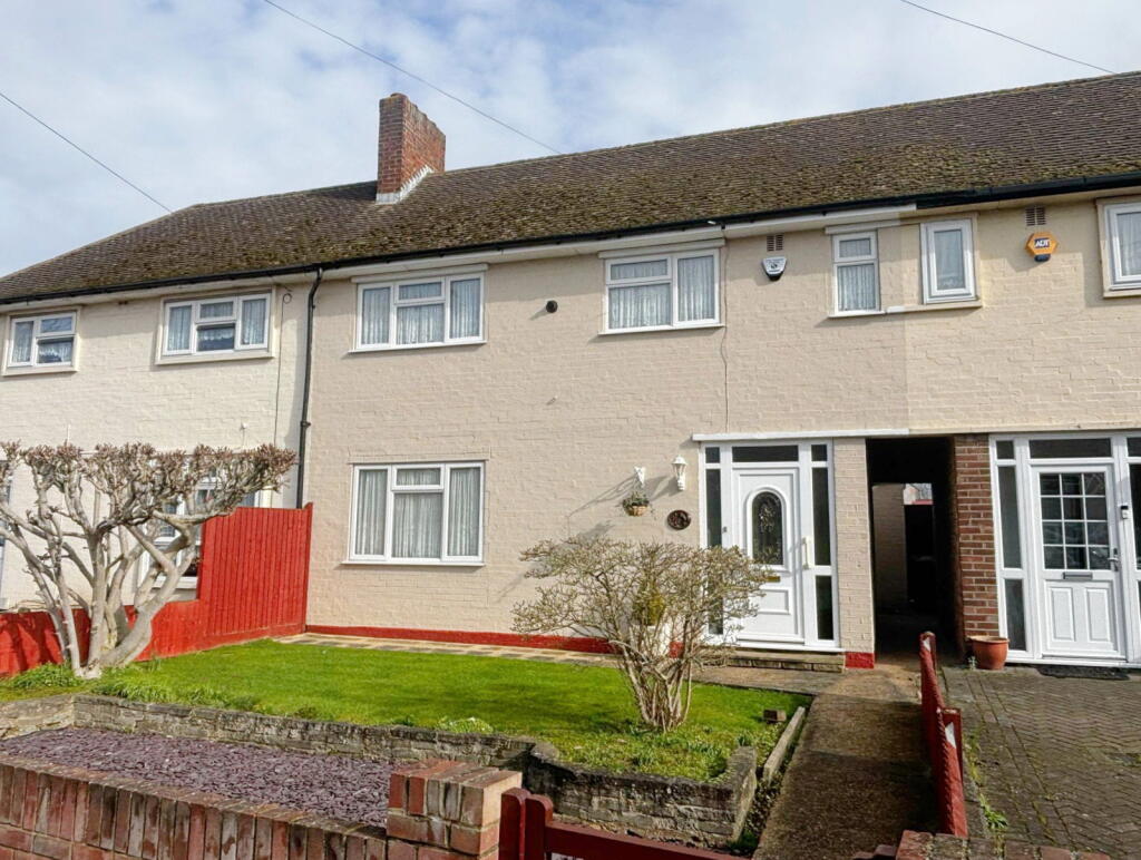
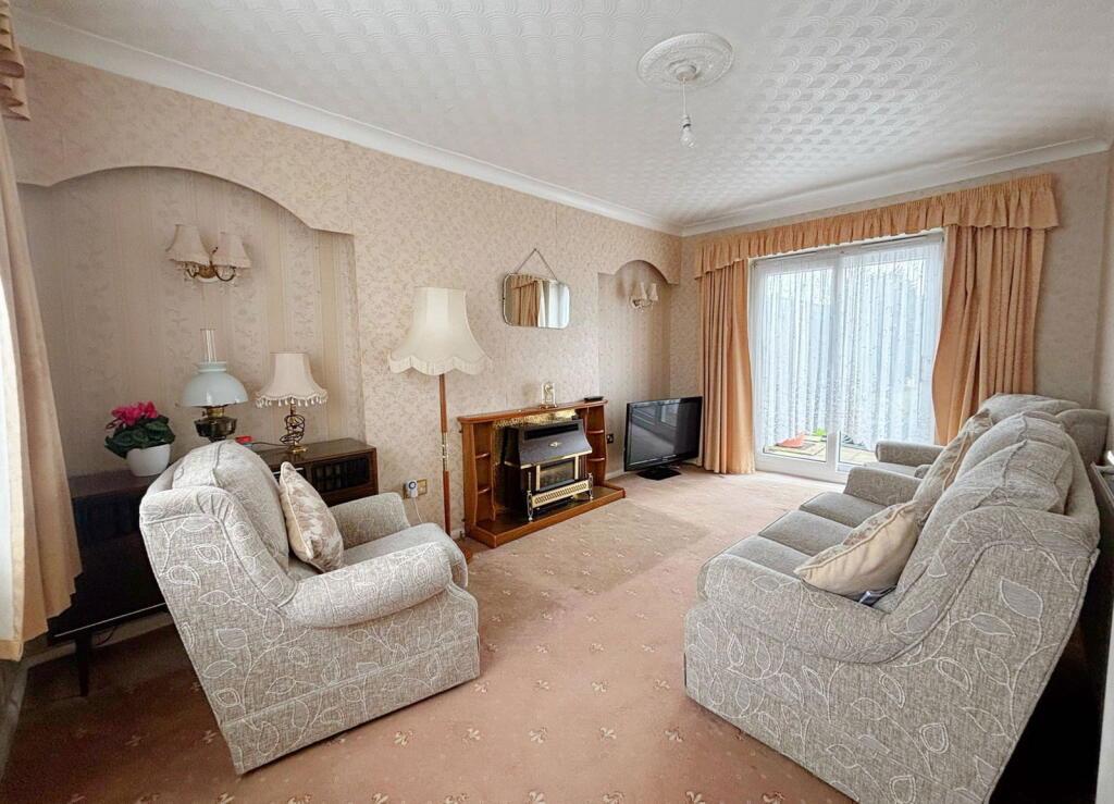
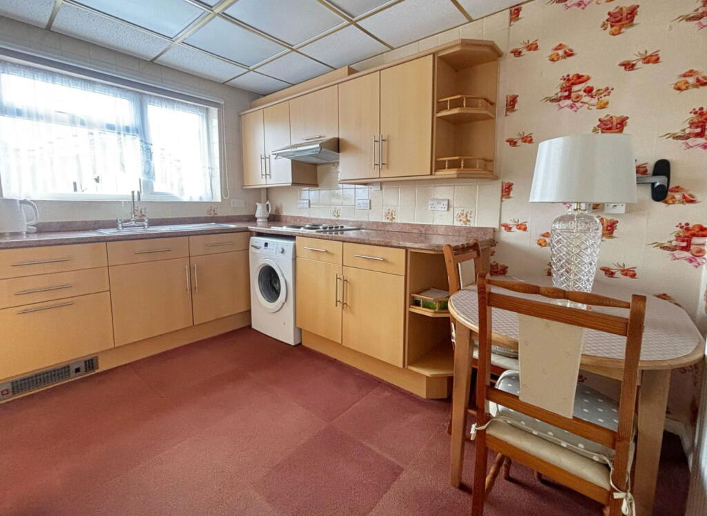
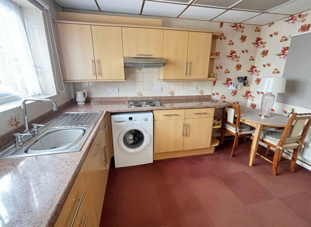
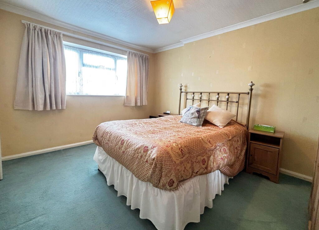
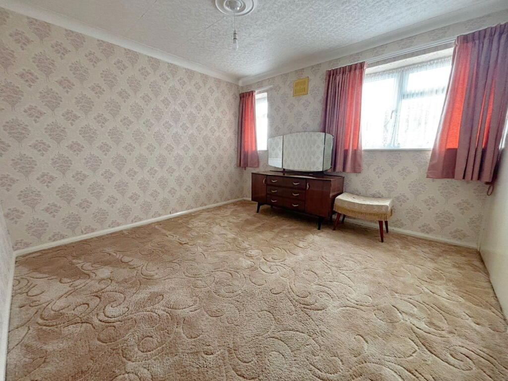


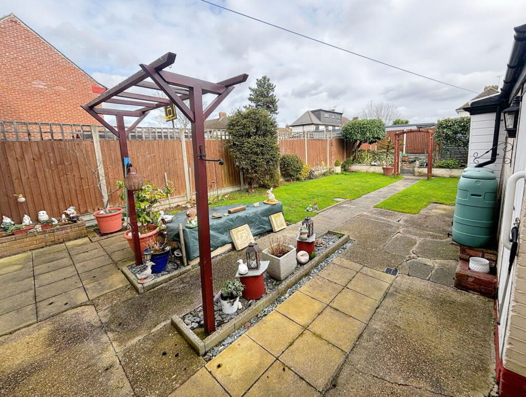
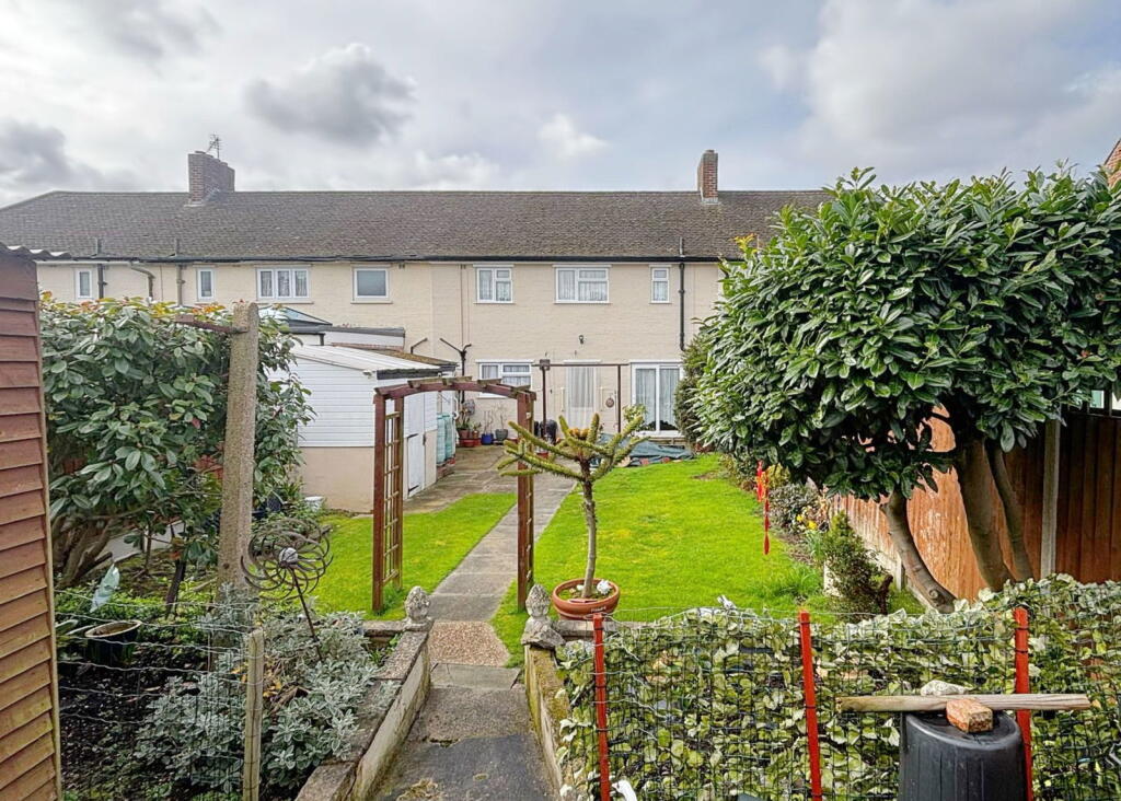
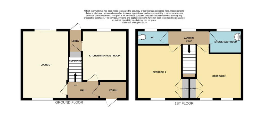
Photo 1 Photo 2 Photo 3 Photo 4 Photo 5 Photo 6 Photo 7 Photo 8 Photo 9 Photo 10 Photo 11 Photo 12
/ 12
Property details
Floor area
65 m²
EPC rating
C
Last sold
£360,000 Jul 2025
Price per m²
£5,385/m²
Local average
£442,489 (-20.9%)
Deprivation
Decile 4 (10,382 of 33,755)
Street crime
156 incidents within 1 mile (Apr 2026)
Key features
- 2 DOUBLE BEDROOMS
- LOUNGE
- BREAKFAST KITCHEN
- GAS CENTRAL HEATING
- NO UPWARD CHAIN
- DOUBLE GLAZED
- CLOSE TO SHOPS AND BUS ROUTES
Additional details
- Parking
- On street
- Garden
- Yes
Description
Searching for your first home? Prefer to own a house over a flat? This should be the ideal property for you. A lovely 2 bedroom terrace close to bus routes into Romford and walking distance to shops, park and other amenities - that will require some modernisation and upgrading but realistically priced to take this into account. With no upward chain a quick sale can be achieved. Hurry to book your viewing now!
It's actually quite roomy for a 2 bedroom house and would suit a young couple. The lounge will take good size furniture and has patio doors leading out to the garden.
Everyone wants a good size kitchen and this one doesn't disappoint. Plenty of room to upgrade to a lovely modern kitchen, which also leads out to the garden.
Upstairs there is a wet room with a separate wc and 2 really good size double bedrooms.
Outside you'll find a well maintained garden, which would be perfect for a young family and there is also a side entrance 'tunnel' leading to the front.
You can park on the road in front of the house, but the front garden is big enough for off road parking, subject to getting permission for a drop kerb.
London Borough of Havering Council Tax Band C - £1,962.59 (2024/2025)
EPC information to follow
...............................
Porch Entrance to hall
Lounge 15'7 x 10'2 (4.78m x 3.10m)
Breakfast/Kitchen 11'7 x 9'3 (3.56m x 2.83m)
First Floor
Bedroom 1 12'4 x 10'3 (3.77m x 3.13m)
Bedroom 2 11'2 x 10'5 (3.41m x 3.20m)
Wet Room/Shower Room
Separate WC
Exterior Good size garden. Potential for off road parking to front
Listed by
South East
exp world uk limited
Reference: 158924648
EPC Rating & Upgrade Cost
Current rating: C
Potential rating: B
Inspection date: 06/03/2025
Expiry date: 05/03/2035
Current heating cost: £583/year
Potential heating cost: £540/year
Est. upgrade cost to C: £14,510
Recommendations
- Floor insulation (solid floor) (£4,000 - £6,000)
- Low energy lighting for all fixed outlets (£10)
- Solar water heating (£4,000 - £6,000)
- Solar photovoltaic panels, 2.5 kWp (£3,500 - £5,500)
Flood risk
Zone: 1
Risk: Low
Job (default Low)
Floorplans

Floorplan 1
Price history
| Event | Date | Price | % change |
|---|---|---|---|
| Sold | 14/07/2025 (11 months ago) | £360,000 | — |
Source: HM Land Registry Price Paid Data. Crown copyright.
Sold Comparables
Same street and nearby sales within 0.25 miles (last 5 years). Data from Land Registry Price Paid.
| Address | Price | Date | Type |
|---|---|---|---|
| 145 LYNTON AVENUE, ROMFORD, HAVERING, GREATER LONDON, RM7 8NB | £385,000 | 21/08/2025 | Terraced |
| 33 VICTORY WAY, ROMFORD, HAVERING, GREATER LONDON, RM7 8PA | £405,000 | 10/07/2025 | Terraced |
| 14 RODNEY WAY, ROMFORD, HAVERING, GREATER LONDON, RM7 8PD | £460,000 | 03/11/2023 | Terraced |
| 16 RODNEY WAY, ROMFORD, HAVERING, GREATER LONDON, RM7 8PD | £435,600 | 10/11/2022 | Terraced |
| 8 ARGUS CLOSE, ROMFORD, HAVERING, GREATER LONDON, RM7 8NJ | £550,000 | 07/11/2022 | Terraced |
| 149 LYNTON AVENUE, ROMFORD, HAVERING, GREATER LONDON, RM7 8NB | £420,000 | 27/10/2022 | Terraced |
| 8 HOOD WALK, ROMFORD, HAVERING, GREATER LONDON, RM7 8NU | £423,000 | 26/10/2022 | Terraced |
| 151 LYNTON AVENUE, ROMFORD, HAVERING, GREATER LONDON, RM7 8NB | £397,500 | 25/10/2022 | Terraced |
| 11 RAMSDEN DRIVE, COLLIER ROW, ROMFORD, HAVERING, GREATER LONDON, RM5 2NJ | £550,000 | 21/07/2022 | Terraced |
| 1 RAMSDEN DRIVE, COLLIER ROW, ROMFORD, HAVERING, GREATER LONDON, RM5 2NJ | £545,000 | 20/07/2022 | Terraced |
| 21 ELIZABETH CLOSE, ROMFORD, HAVERING, GREATER LONDON, RM7 8NX | £375,000 | 01/07/2022 | Terraced |
| 9 RAMSDEN DRIVE, COLLIER ROW, ROMFORD, HAVERING, GREATER LONDON, RM5 2NJ | £437,750 | 16/06/2022 | Terraced |
| 22 MELVILLE ROAD, ROMFORD, HAVERING, GREATER LONDON, RM5 2AJ | £520,000 | 12/05/2022 | Terraced |
| 85 LOWSHOE LANE, ROMFORD, HAVERING, GREATER LONDON, RM5 2AS | £380,000 | 31/03/2022 | Terraced |
| 12A RAMSDEN DRIVE, COLLIER ROW, ROMFORD, HAVERING, GREATER LONDON, RM5 2NJ | £415,000 | 25/02/2022 | Terraced |
| Same street 132 WHITE HART LANE, COLLIER ROW, ROMFORD, HAVERING, GREATER LONDON, RM7 8LX | £350,995 | 14/02/2022 | Terraced |
| 4 ARGUS CLOSE, ROMFORD, HAVERING, GREATER LONDON, RM7 8NJ | £430,000 | 25/01/2022 | Terraced |
| 3 RAMSDEN DRIVE, COLLIER ROW, ROMFORD, HAVERING, GREATER LONDON, RM5 2NJ | £334,000 | 30/06/2021 | Terraced |
Street average: £350,995 (1 sale)
Area average: £438,991 (17 sales)
Capital growth trend
Land Registry outcode average: last 12 months vs 5y and 10y ago (from sold prices).
House Price Index (HM Land Registry — official index, not sold-price averages): Havering. Series: Terraced. As of March 2026.
Rental Range
Estimated market rent for Havering. Low = conservative, Realistic = average, Optimistic = best case.
Based on Local Authority from postcode lookup → Havering.
LHA (30th percentile) floor for Outer North East London: £1,247/mo (Apr 2025 – Mar 2026)
Location
Nearby
Nearest stations, universities and amenities (distance from property).
| Type | Name | Distance |
|---|---|---|
| Bus stop | Collier Row Road | 0.0 miles |
| Bus stop | Howe Close | 0.1 miles |
| Shop | The Loft Shop | 0.2 miles |
| Shop | Unknown | 0.2 miles |
| Train station | Romford | 1.9 miles |
| Train station | Chadwell Heath | 2.3 miles |
| Hospital | Suttons Manor Hospital | 4.7 miles |
| Hospital | Neonatal Unit, L1 Z2 | 7.2 miles |
| University | University of Portsmouth Walthamstow Campus | 7.5 miles |
| University | Arden University Stratford Campus | 8.0 miles |
Street-level crime
| Category | Count |
|---|---|
| Violence and sexual offences | 51 |
| Anti-social behaviour | 31 |
| Vehicle crime | 19 |
| Other theft | 15 |
| Shoplifting | 13 |
| Public order | 8 |
| Criminal damage and arson | 5 |
| Drugs | 5 |
| Burglary | 3 |
| Robbery | 3 |
| Other crime | 1 |
| Possession of weapons | 1 |
| Theft from the person | 1 |
| Total incidents | 156 |
Within 1 mile during Apr 2026. Source: data.police.uk (England & Wales).
Schools nearby
Nearest open schools with Ofsted ratings (England). Closed schools are not shown. Data from Get Information about Schools and Ofsted.
| Name | Type | Distance | Ofsted |
|---|---|---|---|
| St Patrick's Catholic Primary School | Primary | 0.2 miles | Good — 15 Jun 2012 |
| Crownfield Junior School | Primary | 0.3 miles | Good — 11 Jun 2014 |
| Crownfield Infant School | Primary | 0.3 miles | Good — 15 Oct 2014 |
| Clockhouse Primary School | Primary | 0.6 miles | Outstanding — 16 Jul 2023 |
| Parklands Primary School | Primary | 0.9 miles | Good — 9 Jun 2024 |
Rental Comparables
Residential lets from OpenRent and Rightmove for the area (same bedroom count). Use to validate rent estimates. Student lets are excluded.
| Title | Rent | Beds | Distance | As seen on |
|---|---|---|---|---|
| 2 Bed Bungalow, Redriff Road, RM7 | £500/mo | 2 | 0.5 miles | OpenRent |
Average rent: £500/mo (1 listing)
Rent-driven metrics
Based on OpenRent comparables.
- Rent ratio — Monthly rent ÷ purchase price (1% rule). 1%+ = strong, 0.8–1% = okay, <0.8% = weak for cashflow.
- Max investor price — Rent ÷ 0.8%; the price at which rent would be 0.8% of price (Stoke-style target).
- Target investor price — Rent ÷ 1%; the price at which rent would be 1% of price (strong cashflow band).
- Gross yield — Annual rent as % of purchase price (no costs).
- Cost-to-rent — Price ÷ annual rent (from OpenRent comparables). Under 14× = strong, 14–16× = acceptable, 17×+ = compressed.
- Cashflow — Rent minus mortgage, 10% maintenance, £25/mo compliance. Assumes 75% LTV, 3.95% APR (5yr fixed), 25yr term.
- ROI — Annual profit ÷ cash in (deposit + 4% purchase costs).