St Annes Court
St Annes Street, Liverpool, L3 3JP
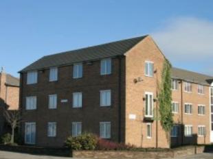
Photo 1
/ 1
Property details
Last sold
£105,000
Local average
£163,795 (-34.1%)
Deprivation
Decile 2 (4,846 of 33,755)
Street crime
1700 incidents within 1 mile (Apr 2026)
Key features
- Modern development
- Top floor apartment
- Two double bedrooms
- L-shaped lounge/dining area
- Economy 7 heating
- Allocated parking
- City centre location
- Viewing highly recommended
Description
Dimensions
Bedroom 1:
Bedroom 2:
Reception 1:
Reception 2:
Kitchen:
13 3x9 7
9 9x9 7
L-shaped
13 3x18 8
9 8x6 9
Listed by
Liverpool
Bradshaw Farnham & Lea
Reference: 15379307
EPC ratings on this postcode
We don't have a matched EPC for this property yet. Below are efficiency scores and details for other addresses on this postcode.
| Address | Current | Potential | Floor area | Age band | Type |
|---|---|---|---|---|---|
| 1, St. Annes Court, St. Anne Street, LIVERPOOL | 59 | 76 | 43 m² | England and Wales: 1930-1949 | Flat |
| 10, St. Annes Court, St. Anne Street, LIVERPOOL | 51 | 75 | 45 m² | England and Wales: 1930-1949 | Flat |
| 11, St. Annes Court, St. Anne Street, LIVERPOOL | 46 | 77 | 43 m² | England and Wales: 1967-1975 | Flat |
| 15 St. Annes Court, St. Anne Street, LIVERPOOL | 62 | 76 | 41 m² | England and Wales: 1950-1966 | Flat |
| 15, St. Annes Court, St. Anne Street, LIVERPOOL | 58 | 74 | 45 m² | England and Wales: 1930-1949 | Flat |
| 16 St. Annes Court, St. Anne Street, LIVERPOOL | 70 | 75 | 34 m² | England and Wales: 1967-1975 | Flat |
| 16 St. Annes Court, St. Anne Street, LIVERPOOL | 45 | 76 | 34 m² | England and Wales: 1967-1975 | Flat |
| 16, St. Annes Court, St. Anne Street, LIVERPOOL | 57 | 76 | 43 m² | England and Wales: 1930-1949 | Flat |
| 17 ST ANNES COURT, 98 ST ANNE STREET, LIVERPOOL, LIVERPOOL | 58 | 74 | 44 m² | England and Wales: 1991-1995 | Flat |
| 18 St. Annes Court, St. Anne Street, LIVERPOOL | 58 | 79 | 45 m² | England and Wales: 1950-1966 | Flat |
| 18, St. Annes Court, St. Anne Street, LIVERPOOL | 70 | 70 | 44 m² | England and Wales: 1967-1975 | Flat |
| 19 St. Annes Court, St. Anne Street, LIVERPOOL | 67 | 79 | 45 m² | England and Wales: 1967-1975 | Flat |
| 20 St. Annes Court, St. Anne Street, LIVERPOOL | 75 | 79 | 44 m² | England and Wales: 2003-2006 | Flat |
| 20 ST. ANNES COURT, ST. ANNE STREET, LIVERPOOL | 65 | 77 | 41 m² | England and Wales: 1967-1975 | Flat |
| 22 ST ANNES COURT, 98 ST ANNE STREET, LIVERPOOL | 36 | 74 | 60 m² | England and Wales: 1930-1949 | Flat |
Flood risk
Zone: 1
Risk: Low
Job (default Low)
Price history
195% since 1997
| Event | Date | Price | % change |
|---|---|---|---|
| Sold | 01/01/2007 (19 years ago) | £105,000 | +194.5% |
| Sold | 01/01/1997 (29 years ago) | £35,650 | — |
Source: HM Land Registry Price Paid Data. Crown copyright.
Sold Comparables
Same street and nearby sales within 0.25 miles (last 5 years). Data from Land Registry Price Paid.
| Address | Price | Date | Type |
|---|---|---|---|
| 160 APARTMENT 404 RICHMOND ROW, LIVERPOOL, MERSEYSIDE, L3 3BL | £245,000 | 08/12/2025 | Flat |
| Same street 26 ST ANNES COURT, LIVERPOOL, MERSEYSIDE, L3 3JP | £95,000 | 20/06/2025 | Flat |
| 160 APARTMENT 403 RICHMOND ROW, LIVERPOOL, MERSEYSIDE, L3 3BL | £280,000 | 07/02/2025 | Flat |
| Same street 29 ST ANNES COURT, LIVERPOOL, MERSEYSIDE, L3 3JP | £99,250 | 06/12/2024 | Flat |
| Same street 25 ST ANNES COURT, LIVERPOOL, MERSEYSIDE, L3 3JP | £105,000 | 22/11/2024 | Flat |
| Same street 1 ST ANNES COURT, LIVERPOOL, MERSEYSIDE, L3 3JP | £80,000 | 29/02/2024 | Flat |
| Same street 31 ST ANNES COURT, LIVERPOOL, MERSEYSIDE, L3 3JP | £90,000 | 04/08/2023 | Flat |
| Same street 20 ST ANNES COURT, LIVERPOOL, MERSEYSIDE, L3 3JP | £75,000 | 16/06/2023 | Flat |
| FOX STREET VILLAGE UNIT AF 9 FOX STREET, LIVERPOOL, MERSEYSIDE, L3 3BQ | £30,000 | 01/03/2023 | Flat |
| Same street 34 ST ANNES COURT, LIVERPOOL, MERSEYSIDE, L3 3JP | £96,000 | 22/02/2023 | Flat |
| Same street 17 ST ANNES COURT, LIVERPOOL, MERSEYSIDE, L3 3JP | £46,000 | 13/09/2022 | Flat |
| Same street 11 ST ANNES COURT, LIVERPOOL, MERSEYSIDE, L3 3JP | £79,000 | 02/12/2021 | Flat |
| Same street 28 ST ANNES COURT, LIVERPOOL, MERSEYSIDE, L3 3JP | £100,000 | 04/08/2021 | Flat |
| FOX STREET VILLAGE UNIT ET 1 FOX STREET, LIVERPOOL, MERSEYSIDE, L3 3BQ | £40,000 | 21/06/2021 | Flat |
Street average: £86,525 (10 sales)
Area average: £148,750 (4 sales)
Capital growth trend
Land Registry outcode average: last 12 months vs 5y and 10y ago (from sold prices).
House Price Index (HM Land Registry — official index, not sold-price averages): Liverpool. Series: Flats and maisonettes. As of March 2026.
Rental Range
Estimated market rent for Liverpool. Low = conservative, Realistic = average, Optimistic = best case.
Based on Local Authority from postcode lookup → Liverpool.
LHA (30th percentile) floor for Greater Liverpool: £593/mo (Apr 2025 – Mar 2026)
Location
Address
Richmond Row
Nearby
Nearest stations, universities and amenities (distance from property).
| Type | Name | Distance |
|---|---|---|
| Bus stop | ST ANNE STREET/JUVENAL STREET | 0.1 miles |
| Bus stop | ST ANNE STREET/POLICE STATION | 0.1 miles |
| Shop | Weatherspoons | 0.2 miles |
| Shop | Bestway Cash and Carry | 0.2 miles |
| University | Liverpool John Moores University City Campus | 0.4 miles |
| University | Liverpool Hope University | 0.4 miles |
| Train station | Liverpool Lime Street | 0.5 miles |
| Train station | Moorfields | 0.6 miles |
| Hospital | Royal Liverpool University Hospital | 0.7 miles |
| Hospital | Breckfield and North Everton | 0.9 miles |
Street-level crime
| Category | Count |
|---|---|
| Violence and sexual offences | 508 |
| Drugs | 305 |
| Shoplifting | 201 |
| Public order | 170 |
| Anti-social behaviour | 158 |
| Other theft | 93 |
| Criminal damage and arson | 82 |
| Burglary | 48 |
| Other crime | 37 |
| Vehicle crime | 35 |
| Theft from the person | 25 |
| Possession of weapons | 17 |
| Robbery | 13 |
| Bicycle theft | 8 |
| Total incidents | 1700 |
Within 1 mile during Apr 2026. Source: data.police.uk (England & Wales).
Schools nearby
Nearest open schools with Ofsted ratings (England). Closed schools are not shown. Data from Get Information about Schools and Ofsted.
| Name | Type | Distance | Ofsted |
|---|---|---|---|
| Millstead School | Other | 0.3 miles | Outstanding — 28 Mar 2013 |
| Faith Primary Academy | Primary | 0.3 miles | Good — 14 Jan 2019 |
| Holy Cross Catholic Primary School | Primary | 0.3 miles | Good — 17 Apr 2018 |
| The Trinity Catholic Academy | Primary | 0.5 miles | Inadequate — 13 May 2019 |
| Everton Nursery School and Family Centre | Nursery | 0.5 miles | Outstanding — 17 Jun 2014 |
Rental Comparables
Rental listings exist nearby, but none matched the 2-bedroom count for this property.
Rent-driven metrics
Based on Area rent estimate.
- Rent ratio — Monthly rent ÷ purchase price (1% rule). 1%+ = strong, 0.8–1% = okay, <0.8% = weak for cashflow.
- Max investor price — Rent ÷ 0.8%; the price at which rent would be 0.8% of price (Stoke-style target).
- Target investor price — Rent ÷ 1%; the price at which rent would be 1% of price (strong cashflow band).
- Gross yield — Annual rent as % of purchase price (no costs).
Enter House Number
Enter the house number to help us retrieve more accurate pricing history and property data.
Please log in to submit or correct the house number for this listing.
Log in to continue