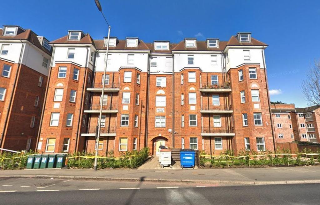
Sheila House
North Circular Road, Golders Green, NW11, NW11 9LD
£1,322 pcm
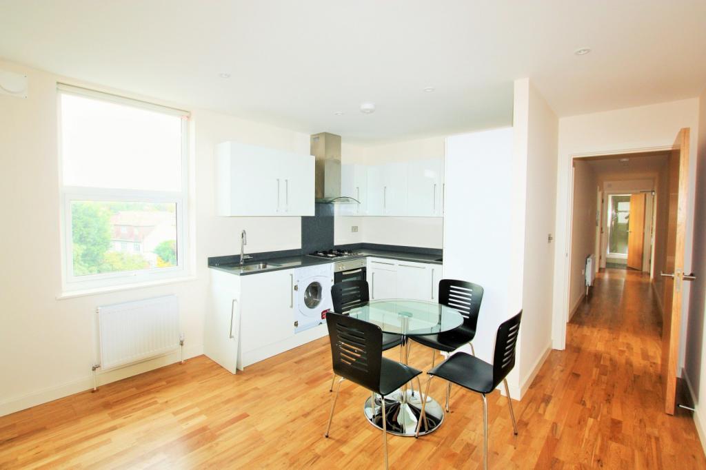
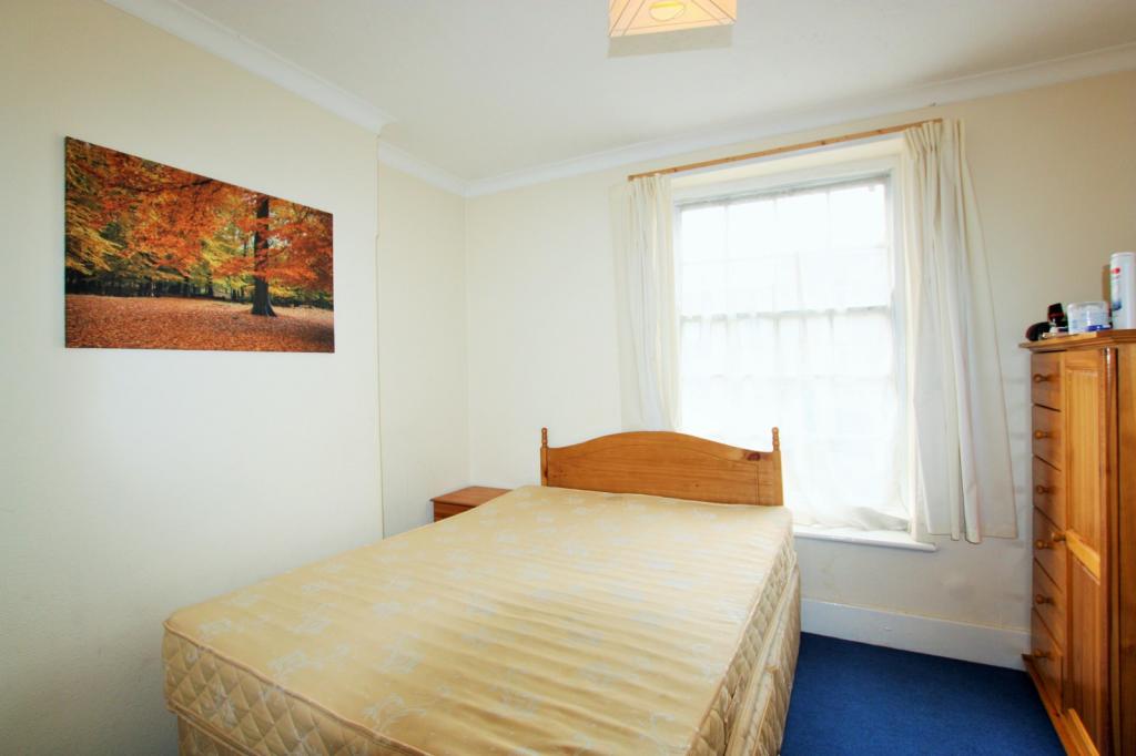
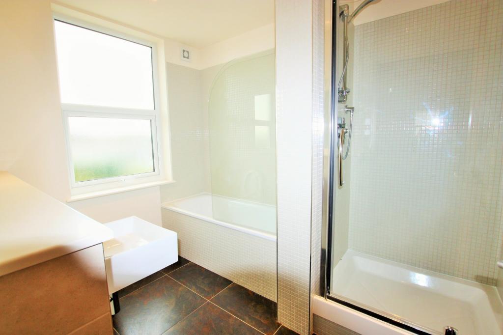
Property details
Deprivation
Decile 4 (11,276 of 33,755)
Street crime
578 incidents within 1 mile (Apr 2026)
Description
****
General: While we endeavour to make our sales particulars fair, accurate and reliable, they are only a general guide to the property and, accordingly, if
there is any point which is of particular importance to you, please contact the office and we will be pleased to check the position for you, especially if
you are contemplating travelling some distance to view the property. Measurements: These approximate room sizes are only intended as general
guidance. You must verify the dimensions carefully before ordering carpets or any built-in furniture. Services: Please note we have not tested the
services or any of the equipment or appliances in this property, accordingly we strongly advise prospective buyers to commission their own survey or
service reports before finalizing their offer to purchase. THESE PARTICULARS ARE ISSUED IN GOOD FAITH BUT DO NOT CONSTITUTE
REPRESENTATIONS OF FACT OR FORM PART OF ANY OFFER OR CONTRACT. THE MATTERS REFERRED TO IN THESE PARTICULARS SHOULD BE
INDEPENDENTLY VERIFIED BY PROSPECTIVE BUYERS OR TENANTS. NEITHER ROUNDTREE NOR ANY OF ITS EMPLOYEES OR AGENTS HAS ANY
AUTHORITY TO MAKE OR GIVE ANY REPRESENTATION OR WARRANTY WHATEVER IN RELATION TO THIS PROPERTY.
Listed by
London
Roundtree Real Estate
Reference: 79021596
EPC ratings on this postcode
We don't have a matched EPC for this property yet. Below are efficiency scores and details for other addresses on this postcode.
| Address | Current | Potential | Floor area | Age band | Type |
|---|---|---|---|---|---|
| Flat 1 Sheila House, North Circular Road, LONDON | 57 | 79 | 108 m² | England and Wales: 1930-1949 | Flat |
| Flat 10 Sheila House, North Circular Road, LONDON | 81 | 82 | 61 m² | England and Wales: 2007-2011 | Flat |
| Flat 10, Sheila House, North Circular Road, LONDON | 82 | 82 | 61 m² | England and Wales: 2003-2006 | Flat |
| Flat 11 Sheila House, North Circular Road, LONDON | 81 | 82 | 62 m² | England and Wales: 2007-2011 | Flat |
| Flat 11, Sheila House, North Circular Road, LONDON | 82 | 82 | 63 m² | England and Wales: 2003-2006 | Flat |
| Flat 12 Sheila House, North Circular Road, LONDON | 80 | 82 | 54 m² | England and Wales: 2007-2011 | Flat |
| Flat 12, Sheila House, North Circular Road, LONDON | 81 | 81 | 51 m² | England and Wales: 2003-2006 | Flat |
| Flat 13 Sheila House, North Circular Road, LONDON | 79 | 81 | 80 m² | England and Wales: 2007-2011 | Flat |
| Flat 13, Sheila House, North Circular Road, LONDON | 80 | 80 | 88 m² | England and Wales: 2003-2006 | Flat |
| Flat 14 Sheila House, North Circular Road, LONDON | 77 | 78 | 44 m² | England and Wales: 2007-2011 | Flat |
| Flat 14, Sheila House, North Circular Road, LONDON | 77 | 77 | 41 m² | England and Wales: 2003-2006 | Flat |
| Flat 15 Sheila House, North Circular Road, LONDON | 75 | 77 | 83 m² | England and Wales: 2007-2011 | Flat |
| Flat 15, Sheila House, North Circular Road, LONDON | 80 | 80 | 89 m² | England and Wales: 2003-2006 | Flat |
| Flat 2 Sheila House, North Circular Road, LONDON | 54 | 80 | 110 m² | England and Wales: before 1900 | Flat |
| Flat 2, Sheila House, North Circular Road, LONDON | 68 | 78 | 111 m² | England and Wales: 1900-1929 | Flat |
Flood risk
Zone: 1
Risk: Low
Job (default Low)
Rental Range
Estimated market rent for Barnet. Low = conservative, Realistic = average, Optimistic = best case.
Based on Local Authority from postcode lookup → Barnet.
LHA (30th percentile) floor for Inner North London: £1,789/mo (Apr 2025 – Mar 2026)
Location
Address
Colroy Court
Nearby
Nearest stations, universities and amenities (distance from property).
| Type | Name | Distance |
|---|---|---|
| Bus stop | Bridge Lane | 0.1 miles |
| Shop | Reichs | 0.4 miles |
| Shop | Screwfix | 0.4 miles |
| Train station | Brent Cross | 0.6 miles |
| Train station | Hendon Central | 0.8 miles |
| University | Flood Hazard Research Centre | 1.6 miles |
| University | Middlesex University | 1.6 miles |
| Hospital | Priory Hospital | 5.0 miles |
| Hospital | The Portland Hospital | 5.2 miles |
Street-level crime
| Category | Count |
|---|---|
| Anti-social behaviour | 152 |
| Violence and sexual offences | 130 |
| Vehicle crime | 68 |
| Shoplifting | 59 |
| Public order | 35 |
| Other theft | 31 |
| Burglary | 27 |
| Criminal damage and arson | 22 |
| Drugs | 21 |
| Other crime | 12 |
| Theft from the person | 7 |
| Bicycle theft | 5 |
| Possession of weapons | 5 |
| Robbery | 4 |
| Total incidents | 578 |
Within 1 mile during Apr 2026. Source: data.police.uk (England & Wales).
Schools nearby
Nearest open schools with Ofsted ratings (England). Closed schools are not shown. Data from Get Information about Schools and Ofsted.
| Name | Type | Distance | Ofsted |
|---|---|---|---|
| Talmud Torah Tiferes Shlomo | Other | 0.2 miles | Requires improvement — 23 Jul 2024 |
| Independent Jewish Day School | Primary | 0.3 miles | Requires improvement — 2 Feb 2023 |
| Ateres Beis Yaakov | Other | 0.3 miles | Good — 14 Jul 2024 |
| Saracens Bell Lane | Primary | 0.4 miles | Requires improvement — 6 Dec 2021 |
| WENTWORTH COLLEGE | Other | 0.4 miles | Good — 14 Nov 2022 |
Rental Comparables
Residential lets from OpenRent and Rightmove for the area (same bedroom count). Use to validate rent estimates. Student lets are excluded.
| Title | Rent | Beds | Distance | As seen on |
|---|---|---|---|---|
| 2 Bed Flat, Hallswelle Road, NW11 | £2,200/mo | 2 | 0.33 miles | OpenRent |
| 2 Bed Semi-Detached House, Highfield Road, NW11 | £2,695/mo | 2 | 0.43 miles | OpenRent |
Average rent: £2,448/mo (2 listings)
Enter House Number
Enter the house number to help us retrieve more accurate pricing history and property data.
Please log in to submit or correct the house number for this listing.
Log in to continue