13 ORMOND STREET
NEATH, NEATH PORT TALBOT SA11 2TG
£99,500
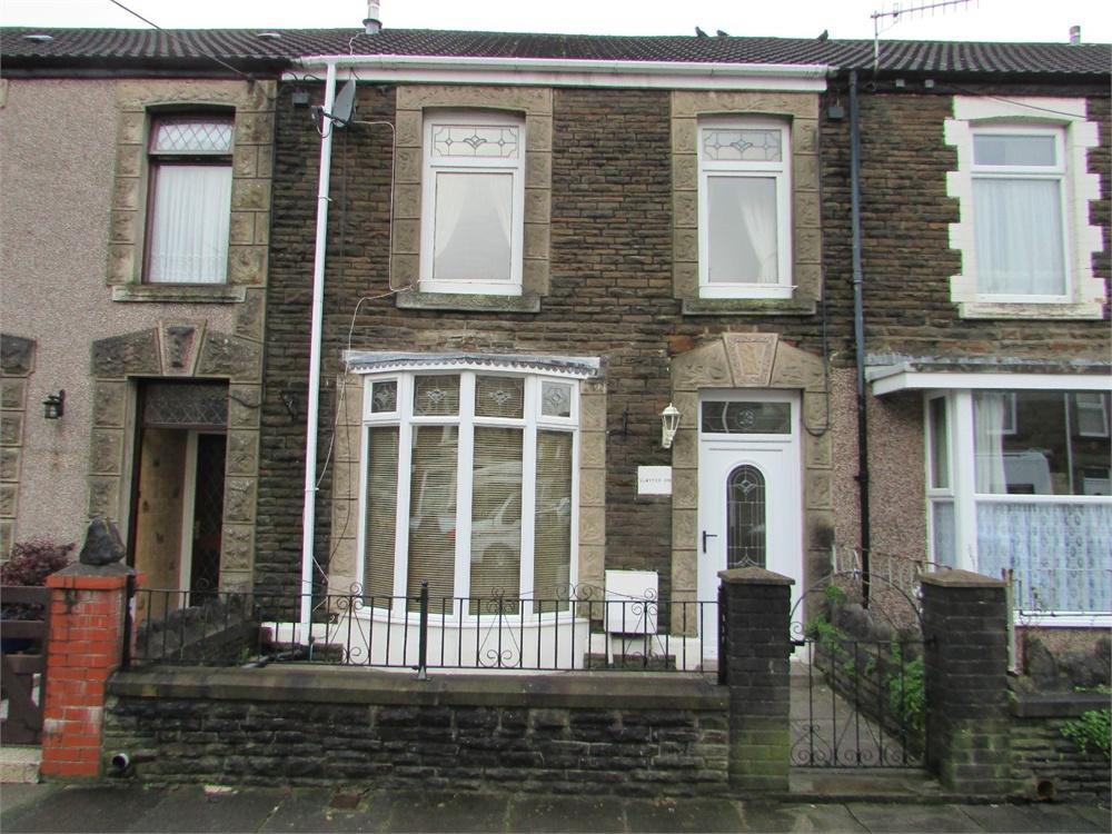
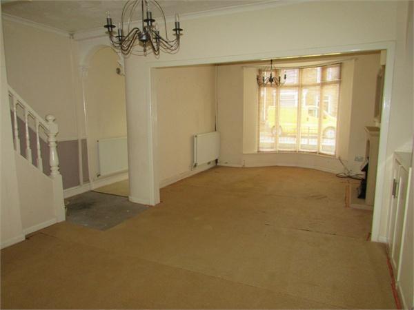
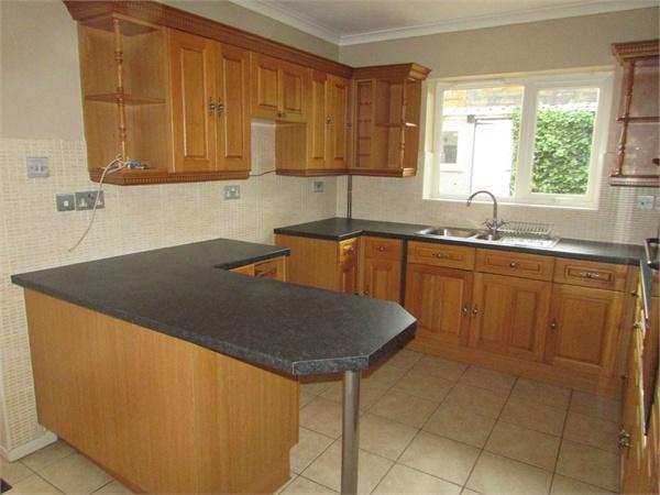
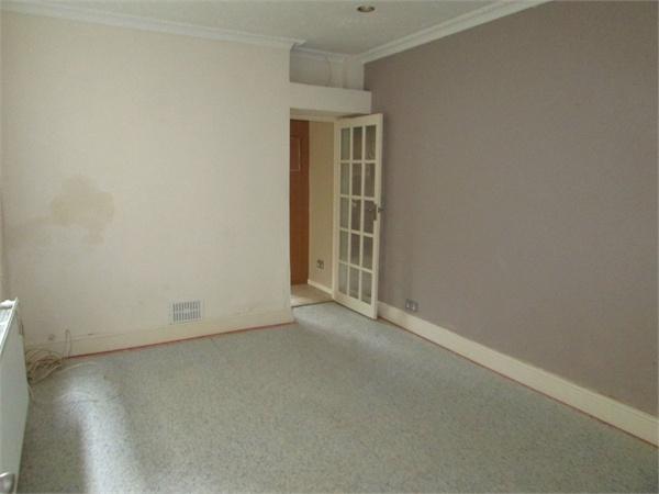
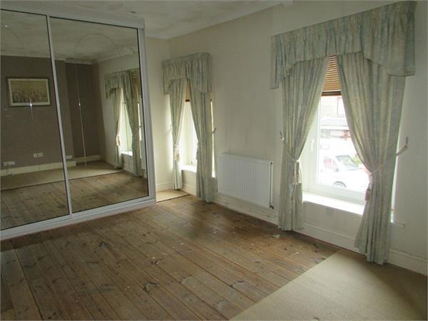
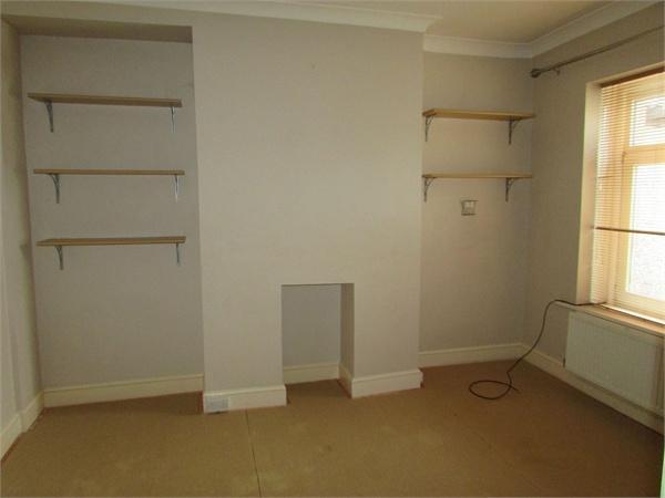
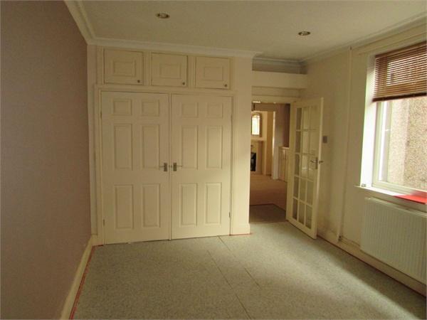
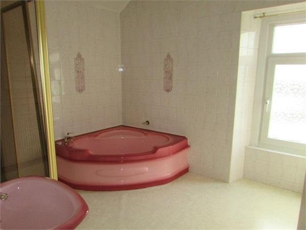
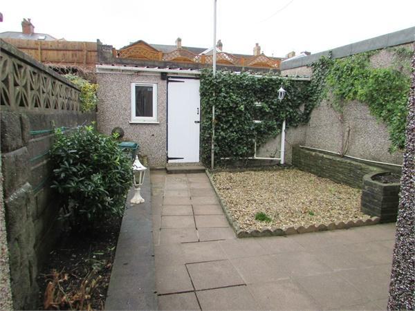
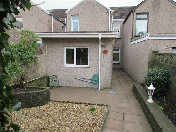
Photo 1 Photo 2 Photo 3 Photo 4 Photo 5 Photo 6 Photo 7 Photo 8 Photo 9 Photo 10
/ 10
Property details
Tenure
FREEHOLD
Last sold
£91,000 May 2016
Local average
£121,701 (-18.2%)
Street crime
65 incidents within 1 mile (Apr 2026)
Key features
- EPC Rating: F
- Terraced House
- Two Receptions
- uPVC Double Glazing
- Gas Fired Heating
- Great First Time Buy
- Enclosed Rear Garden
- Close to Local Amenities
- Need a Mortgage? We Can Help!
Additional details
- Garden
- Yes
Description
Property ref: 121_11_4032640
Listed by
Neath
Peter Morgan
Reference: 57553250
EPC Rating & Upgrade Cost
Fetching EPC data… Refresh this page in a moment.
Flood risk
Zone: 1
Risk: Low
Job (default Low)
EPC Graphs
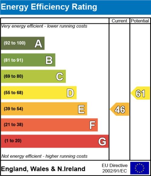
EER
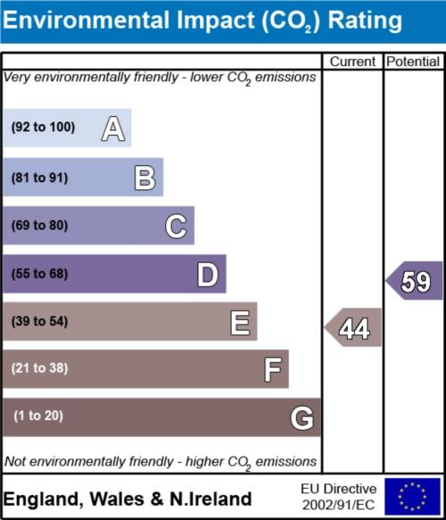
EIR
Price history
| Event | Date | Price | % change |
|---|---|---|---|
| Sold | 06/05/2016 (10 years ago) | £91,000 | — |
Source: HM Land Registry Price Paid Data. Crown copyright.
Sold Comparables
Same street and nearby sales within 0.25 miles (last 5 years). Data from Land Registry Price Paid.
| Address | Price | Date | Type |
|---|---|---|---|
| 42 YNYSYMAERDY ROAD, BRITON FERRY, NEATH, NEATH PORT TALBOT, SA11 2TL | £150,000 | 16/01/2026 | Terraced |
| 7 GOWER STREET, BRITON FERRY, NEATH, NEATH PORT TALBOT, SA11 2SW | £160,000 | 09/12/2025 | Terraced |
| 16 OSTERLEY STREET, NEATH, NEATH PORT TALBOT, SA11 2NY | £141,500 | 04/12/2025 | Terraced |
| 53 YNYSYMAERDY ROAD, BRITON FERRY, NEATH, NEATH PORT TALBOT, SA11 2TE | £163,000 | 31/01/2025 | Terraced |
| 7 ALEXANDER ROAD, BRITON FERRY, NEATH, NEATH PORT TALBOT, SA11 2SN | £101,502 | 20/12/2023 | Terraced |
| 30 SHELONE TERRACE, BRITON FERRY, NEATH, NEATH PORT TALBOT, SA11 2UE | £73,000 | 30/11/2023 | Terraced |
| 15 CWRT SART, NEATH, NEATH PORT TALBOT, SA11 2ST | £149,950 | 10/10/2023 | Terraced |
| 15 YNYSYMAERDY ROAD, BRITON FERRY, NEATH, NEATH PORT TALBOT, SA11 2TE | £75,500 | 04/08/2023 | Terraced |
| 23 YNYSYMAERDY ROAD, BRITON FERRY, NEATH, NEATH PORT TALBOT, SA11 2TE | £87,000 | 04/05/2023 | Terraced |
| 5 ALEXANDER ROAD, BRITON FERRY, NEATH, NEATH PORT TALBOT, SA11 2SN | £175,000 | 30/03/2023 | Terraced |
| 28 MIDDLETON STREET, NEATH, NEATH PORT TALBOT, SA11 2NU | £130,000 | 03/03/2023 | Terraced |
| 47 YNYSYMAERDY ROAD, BRITON FERRY, NEATH, NEATH PORT TALBOT, SA11 2TE | £112,000 | 13/12/2022 | Terraced |
| 6 OSTERLEY STREET, NEATH, NEATH PORT TALBOT, SA11 2NY | £81,500 | 27/10/2022 | Terraced |
| 19 GOWER STREET, BRITON FERRY, NEATH, NEATH PORT TALBOT, SA11 2SW | £150,000 | 26/10/2022 | Terraced |
| 39 YNYSYMAERDY ROAD, BRITON FERRY, NEATH, NEATH PORT TALBOT, SA11 2TE | £119,000 | 14/10/2022 | Terraced |
| 13 OSTERLEY STREET, NEATH, NEATH PORT TALBOT, SA11 2NY | £148,000 | 14/10/2022 | Terraced |
| 11 MIDDLETON STREET, NEATH, NEATH PORT TALBOT, SA11 2NU | £75,000 | 15/09/2022 | Terraced |
| 4 OSTERLEY STREET, NEATH, NEATH PORT TALBOT, SA11 2NY | £135,500 | 31/08/2022 | Terraced |
| 18 OSTERLEY STREET, NEATH, NEATH PORT TALBOT, SA11 2NY | £110,000 | 11/08/2022 | Terraced |
| 17 CWRT SART, NEATH, NEATH PORT TALBOT, SA11 2ST | £179,000 | 08/08/2022 | Terraced |
| Same street 15 ORMOND STREET, NEATH, NEATH PORT TALBOT, SA11 2TG | £159,960 | 19/01/2022 | Other |
| Same street 1A ORMOND STREET, NEATH, NEATH PORT TALBOT, SA11 2TG | £175,000 | 21/12/2021 | Terraced |
Street average: £167,480 (2 sales)
Area average: £125,823 (20 sales)
Capital growth trend
Land Registry outcode average: last 12 months vs 5y and 10y ago (from sold prices).
House Price Index (HM Land Registry — official index, not sold-price averages): Neath Port Talbot. Series: Terraced. As of March 2026.
Rental Range
Estimated market rent for Neath Port Talbot. Low = conservative, Realistic = average, Optimistic = best case.
Based on Local Authority from postcode lookup → Neath Port Talbot.
Location
Nearby
Nearest stations, universities and amenities (distance from property).
| Type | Name | Distance |
|---|---|---|
| Shop | Jim The Trim | 0.1 miles |
| Train station | Briton Ferry | 0.3 miles |
| Shop | Tesco Express | 0.3 miles |
| Bus stop | Unknown | 0.3 miles |
| Train station | Neath | 1.5 miles |
| Hospital | Neath Port Talbot Hospital | 2.9 miles |
| University | Swansea University Bay Campus | 3.3 miles |
| Hospital | Tonna Hospital | 3.5 miles |
| University | UWTSD Swansea | 5.3 miles |
Street-level crime
| Category | Count |
|---|---|
| Violence and sexual offences | 27 |
| Anti-social behaviour | 7 |
| Public order | 7 |
| Other theft | 5 |
| Vehicle crime | 5 |
| Criminal damage and arson | 4 |
| Burglary | 3 |
| Drugs | 3 |
| Shoplifting | 2 |
| Other crime | 1 |
| Possession of weapons | 1 |
| Total incidents | 65 |
Within 1 mile during Apr 2026. Source: data.police.uk (England & Wales).
Schools nearby
Nearest open schools with Ofsted ratings (England). Closed schools are not shown. Data from Get Information about Schools and Ofsted.
| Name | Type | Distance | Ofsted |
|---|---|---|---|
| Ysgol Carreg Hir | Other | 0.3 miles | — (No rating) |
| YGG Tyle'r Ynn | Other | 0.3 miles | — (No rating) |
| Horizons Educare | Other | 0.7 miles | — (No rating) |
| St Joseph's Catholic Primary School (Neath) | Other | 1.2 miles | — (No rating) |
| Gnoll Primary School | Other | 1.4 miles | — (No rating) |
Rental Comparables
Rental listings exist nearby, but none matched the 2-bedroom count for this property.
Rent-driven metrics
Based on Area rent estimate.
- Rent ratio — Monthly rent ÷ purchase price (1% rule). 1%+ = strong, 0.8–1% = okay, <0.8% = weak for cashflow.
- Max investor price — Rent ÷ 0.8%; the price at which rent would be 0.8% of price (Stoke-style target).
- Target investor price — Rent ÷ 1%; the price at which rent would be 1% of price (strong cashflow band).
- Gross yield — Annual rent as % of purchase price (no costs).