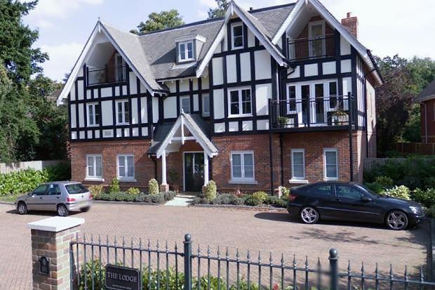
FLAT 2
THE LODGE, 86, PACKHORSE ROAD, GERRARDS CROSS, BUCKINGHAMSHIRE SL9 8JG
£1,000 pcm
Property details
Floor area
40 m²
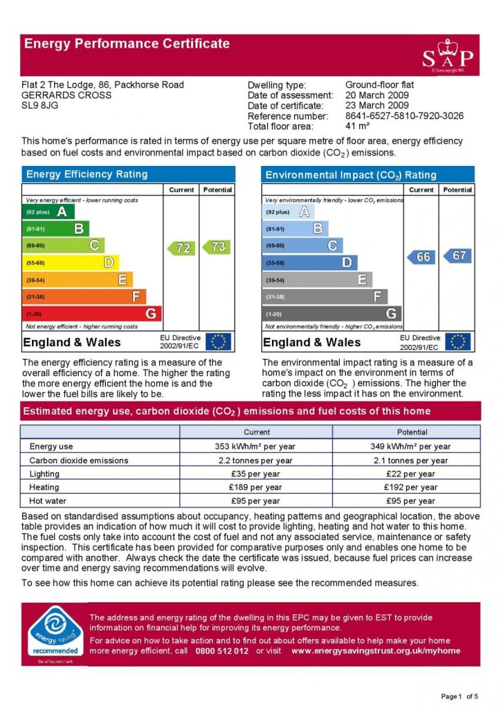
EPC rating
C
Year built
England and Wales: 1991-1995
Deprivation
Decile 10 (33,636 of 33,755)
Street crime
28 incidents within 1 mile (Apr 2026)
Key features
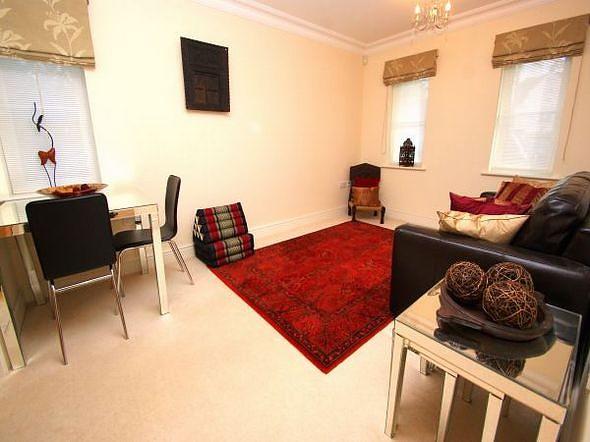
- Lounge
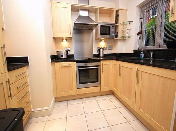
- Modern Fitted Kitchen
- Modern Bathroom
- Double Bedroom
- Communal Gardens
- Parking
Additional details
- Parking
- Yes
Description
Listed by
Gerrards Cross Lettings
BNP Paribas - Strutt & Parker
Reference: 90337066
EPC Rating & Upgrade Cost
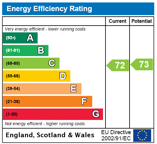
Current rating: C
Potential rating: C
Inspection date: 07/09/2020
Expiry date: 06/09/2030
Current heating cost: £318/year
Potential heating cost: £248/year
Est. upgrade cost to C: £5,655
Recommendations
- Floor insulation (solid floor) (£4,000 - £6,000)
- Heat recovery system for mixer showers (£585 - £725)
Flood risk
Zone: 1
Risk: Low
Job (default Low)
EPC Graphs
EPC
EPC Rating Graph
Rental Range
Estimated market rent for Buckinghamshire. Low = conservative, Realistic = average, Optimistic = best case.
Based on Local Authority from postcode lookup → Buckinghamshire.
LHA (30th percentile) floor for Bedford: £648/mo (Apr 2025 – Mar 2026)
Location
Address
Packhorse Road
Nearby
Nearest stations, universities and amenities (distance from property).
| Type | Name | Distance |
|---|---|---|
| Shop | Coco Nail Bar | 0.2 miles |
| Shop | Unknown | 0.2 miles |
| Train station | Gerrards Cross | 0.3 miles |
| Bus stop | Austenwood Common | 0.4 miles |
| Bus stop | The Bull Hotel | 0.6 miles |
| Train station | Denham Golf Club | 1.7 miles |
| Hospital | Chalfont Centre for Epilepsy | 2.1 miles |
| Hospital | Harefield Hospital | 3.1 miles |
| University | National Film and Television School | 3.7 miles |
| University | Buckinghamshire New University | 4.2 miles |
Street-level crime
| Category | Count |
|---|---|
| Violence and sexual offences | 7 |
| Shoplifting | 5 |
| Criminal damage and arson | 4 |
| Anti-social behaviour | 3 |
| Public order | 3 |
| Burglary | 2 |
| Vehicle crime | 2 |
| Other theft | 1 |
| Possession of weapons | 1 |
| Total incidents | 28 |
Within 1 mile during Apr 2026. Source: data.police.uk (England & Wales).
Schools nearby
Nearest open schools with Ofsted ratings (England). Closed schools are not shown. Data from Get Information about Schools and Ofsted.
| Name | Type | Distance | Ofsted |
|---|---|---|---|
| St Mary's School | Other | 0.1 miles | — (No rating) |
| Thorpe House School | Other | 0.3 miles | — (No rating) |
| Gayhurst School | Other | 0.6 miles | — (No rating) |
| Maltman's Green School | Other | 0.7 miles | — (No rating) |
| St Joseph's Catholic Primary School | Primary | 0.7 miles | Good — 15 Sep 2017 |
Rental Comparables
Residential lets from OpenRent and Rightmove for the area (same bedroom count). Use to validate rent estimates. Student lets are excluded.
| Title | Rent | Beds | Distance | As seen on |
|---|---|---|---|---|
| Studio Flat, The Masons, SL9 | £1,095/mo | 1 | 0.24 miles | OpenRent |
| 1 Bed Flat, The Masons, SL9 | £1,295/mo | 1 | 0.24 miles | OpenRent |
| 1 Bed Flat, Oakridge Place, SL9 | £1,600/mo | 1 | 0.29 miles | OpenRent |
| 1 Bed Flat, Aston House, SL9 | £1,500/mo | 1 | 0.32 miles | OpenRent |
| 1 Bed Flat, Packhorse Road, SL9 | £1,200/mo | 1 | 0.37 miles | OpenRent |
| 1 Bed Flat, Woodlands, SL9 | £1,449/mo | 1 | 0.47 miles | OpenRent |
| 1 Bed Flat, Woodlands, SL9 | £1,549/mo | 1 | 0.47 miles | OpenRent |
| 1 Bed Maisonette, Woodlands, SL9 | £1,549/mo | 1 | 0.47 miles | OpenRent |
| 1 Bed Maisonette, Woodlands, SL9 | £1,549/mo | 1 | 0.47 miles | OpenRent |
| 1 Bed Semi-Detached House, Woodlands, SL9 | £1,649/mo | 1 | 0.47 miles | OpenRent |
Average rent: £1,444/mo (10 listings)