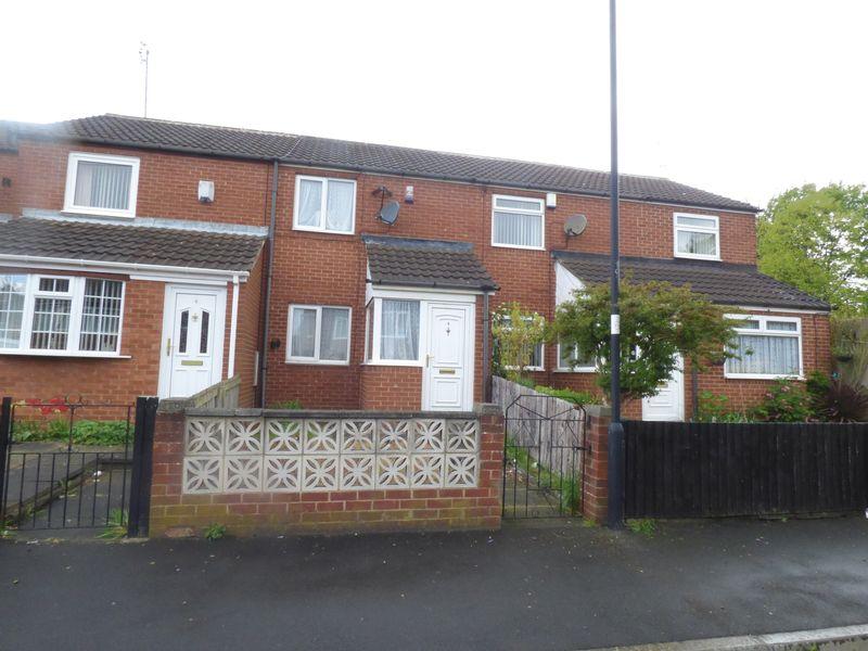
4 GILLIES STREET
NEWCASTLE UPON TYNE, TYNE AND WEAR NE6 2JP
£60,000
Property details
Floor area
62 m²
Last sold
£65,000 Sep 2021
Local average
£216,701 (-72.3%)
Deprivation
Decile 1 (747 of 33,755)
Street crime
487 incidents within 1 mile (Apr 2026)
Key features
- MID TERRACE HOUSE
- 2 BEDROOMS
- GAS CENTRAL HEATING
- DOUBLE GLAZING
- AVAILABLE TO PURCHASE AS PART OF A PORTFOLIO
Description
Internally the property comprises, lounge, kitchen, 2 bedrooms and bathroom/WC.
Additional benefits include gas central heating and double glazing.
Listed by
Heaton
Rook Matthews Sayer - Connells
Reference: 83276741
EPC Rating & Upgrade Cost
Fetching EPC data… Refresh this page in a moment.
Flood risk
Zone: 1
Risk: Low
Job (default Low)
EPC Graphs
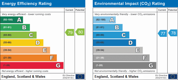
Energy Perform...
Price history
| Event | Date | Price | % change |
|---|---|---|---|
| Sold | 29/09/2021 (4 years ago) | £65,000 | — |
Source: HM Land Registry Price Paid Data. Crown copyright.
Sold Comparables
Same street and nearby sales within 0.25 miles (last 5 years). Data from Land Registry Price Paid.
| Address | Price | Date | Type |
|---|---|---|---|
| Same street 58 GILLIES STREET, NEWCASTLE UPON TYNE, TYNE AND WEAR, NE6 2JP | £130,000 | 22/04/2024 | Semi-detached |
| 109 SCARBOROUGH ROAD, NEWCASTLE UPON TYNE, TYNE AND WEAR, NE6 2RT | £78,000 | 23/10/2023 | Terraced |
| 62 CANTERBURY STREET, NEWCASTLE UPON TYNE, TYNE AND WEAR, NE6 2JD | £55,000 | 03/10/2023 | Terraced |
| Same street 29 GILLIES STREET, NEWCASTLE UPON TYNE, TYNE AND WEAR, NE6 2JP | £72,000 | 28/09/2023 | Flat |
| Same street 10 GILLIES STREET, NEWCASTLE UPON TYNE, TYNE AND WEAR, NE6 2JP | £105,000 | 27/07/2023 | Terraced |
| 87 SCARBOROUGH ROAD, NEWCASTLE UPON TYNE, TYNE AND WEAR, NE6 2RT | £130,000 | 16/12/2022 | Terraced |
| 7 VILLAGE PLACE, NEWCASTLE UPON TYNE, TYNE AND WEAR, NE6 2QF | £80,000 | 18/11/2022 | Terraced |
| 6 BENSON PLACE, NEWCASTLE UPON TYNE, TYNE AND WEAR, NE6 2QT | £92,500 | 28/10/2022 | Terraced |
| 25 DUNMORLIE STREET, NEWCASTLE UPON TYNE, TYNE AND WEAR, NE6 2JL | £121,000 | 14/10/2022 | Terraced |
| 253 BENSON ROAD, NEWCASTLE UPON TYNE, TYNE AND WEAR, NE6 2SD | £50,000 | 01/09/2022 | Terraced |
| Same street 60 GILLIES STREET, NEWCASTLE UPON TYNE, TYNE AND WEAR, NE6 2JP | £120,000 | 26/08/2022 | Semi-detached |
| Same street 23 GILLIES STREET, NEWCASTLE UPON TYNE, TYNE AND WEAR, NE6 2JP | £39,950 | 22/07/2022 | Flat |
| 58 MORTON STREET, NEWCASTLE UPON TYNE, TYNE AND WEAR, NE6 2JH | £72,000 | 06/05/2022 | Terraced |
| 4 RENWICK STREET, NEWCASTLE UPON TYNE, TYNE AND WEAR, NE6 2JE | £100,000 | 04/05/2022 | Terraced |
| 252 GRACE STREET, NEWCASTLE UPON TYNE, TYNE AND WEAR, NE6 2RR | £100,000 | 29/04/2022 | Terraced |
| Same street 7 GILLIES STREET, NEWCASTLE UPON TYNE, TYNE AND WEAR, NE6 2JP | £135,000 | 06/04/2022 | Other |
| 1 TUNSTALL AVENUE, NEWCASTLE UPON TYNE, TYNE AND WEAR, NE6 2RS | £85,000 | 13/07/2021 | Terraced |
Street average: £100,325 (6 sales)
Area average: £87,591 (11 sales)
Capital growth trend
Land Registry outcode average: last 12 months vs 5y and 10y ago (from sold prices).
House Price Index (HM Land Registry — official index, not sold-price averages): Newcastle upon Tyne. Series: Terraced. As of March 2026.
Rental Range
Estimated market rent for Newcastle upon Tyne. Low = conservative, Realistic = average, Optimistic = best case.
Based on Local Authority from postcode lookup → Newcastle upon Tyne.
LHA (30th percentile) floor for Tyneside: £549/mo (Apr 2025 – Mar 2026)
Location
Nearby
Nearest stations, universities and amenities (distance from property).
| Type | Name | Distance |
|---|---|---|
| Shop | Unknown | 0.0 miles |
| Bus stop | Bothal Street | 0.0 miles |
| Bus stop | Welbeck Road-Gillies Street | 0.1 miles |
| Shop | Little Tyre Centre | 0.1 miles |
| Train station | Byker | 0.4 miles |
| Train station | Chillingham Road | 0.6 miles |
| University | Northumbria University City Campus | 1.5 miles |
| University | Ellison Building B Block | 1.5 miles |
| Hospital | Priory Day Hospital | 5.2 miles |
| Hospital | Sunderland Primary care Trust | 5.9 miles |
Street-level crime
| Category | Count |
|---|---|
| Shoplifting | 91 |
| Violence and sexual offences | 91 |
| Anti-social behaviour | 88 |
| Criminal damage and arson | 64 |
| Vehicle crime | 36 |
| Public order | 34 |
| Burglary | 20 |
| Other theft | 19 |
| Robbery | 10 |
| Theft from the person | 10 |
| Other crime | 8 |
| Bicycle theft | 6 |
| Possession of weapons | 6 |
| Drugs | 4 |
| Total incidents | 487 |
Within 1 mile during Apr 2026. Source: data.police.uk (England & Wales).
Schools nearby
Nearest open schools with Ofsted ratings (England). Closed schools are not shown. Data from Get Information about Schools and Ofsted.
| Name | Type | Distance | Ofsted |
|---|---|---|---|
| St Lawrence's Catholic Primary School | Primary | 0.2 miles | Good — 17 Jan 2018 |
| Welbeck Academy | Primary | 0.2 miles | Requires improvement — 25 Feb 2024 |
| Monkchester Road Nursery School | Nursery | 0.4 miles | Outstanding — 12 Dec 2013 |
| Byker Primary School | Primary | 0.4 miles | Outstanding — 29 Sep 2017 |
| St Vincents Catholic Primary School, Newcastle | Primary | 0.6 miles | Good — 17 Sep 2023 |
Rental Comparables
Rental comparables are temporarily unavailable while listing-site fetches are paused. Try again later.
Rent-driven metrics
Based on Area rent estimate.
- Rent ratio — Monthly rent ÷ purchase price (1% rule). 1%+ = strong, 0.8–1% = okay, <0.8% = weak for cashflow.
- Max investor price — Rent ÷ 0.8%; the price at which rent would be 0.8% of price (Stoke-style target).
- Target investor price — Rent ÷ 1%; the price at which rent would be 1% of price (strong cashflow band).
- Gross yield — Annual rent as % of purchase price (no costs).