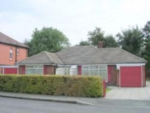
Hillingdon Road
Stretford, M32 8PW
Property details
Last sold
£315,000
Local average
£582,286 (-44.2%)
Deprivation
Decile 8 (25,264 of 33,755)
Street crime
0 incidents within 1 mile (Apr 2026)
Description
THE ACCOMMODATION WITH APPROXIMATE MAXIMUM MEASUREMENTS INCLUDES:
ENTRANCE PORCH:
With sealed unit double glazed windows and front access door and a quarry tiled floor.
SPACIOUS ENTRANCE HALL:
With central heating radiator, built in cloaks cupboard and loft access point.
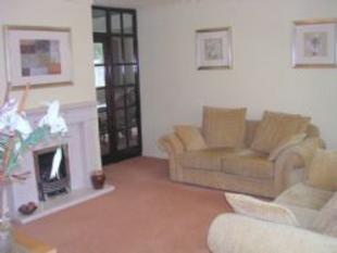
LIVING ROOM:
14'6" x 12'5" sealed unit double glazed window to the front elevation, central heating radiator, cornice ceiling, an inset gas coal effect living flame fire set in a superb Portland stone feature fireplace and hearth. Glazed door leading to the dining room.
EXTENDED DINING ROOM:
16'0" x 10'0" two sealed unit double glazed windows to the rear elevation, two central heating radiators and tongue and groove ceiling.
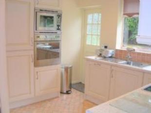
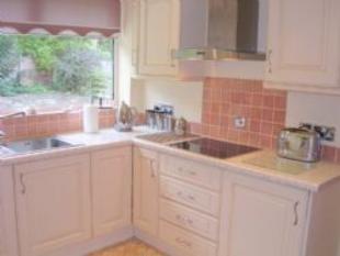
RECENTLY REFITTED KITCHEN:
10'4" x 9'10" having a superb range of fitted wall and base units with contrasting working surfaces and incorporating a single drainer stainless steel sink unit and base, Neff halogen hob, microwave with grill, Circotherm oven/grill, stainless steel extractor hood, washing machine, dishwasher, fridge and separate freezer unit. Built in storage cupboards, one of which houses the gas central heating Vaillant combination boiler, tongue and groove ceiling with inset lights, sealed unit double glazed window to the rear elevation, partially tiled décor to the exposed walls and a ranch style rear access door.
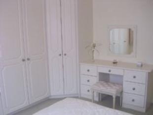
MASTER BEDROOM:
12'5" x 10'7" (plus wardrobe depth) sealed unit double glazed window to the front elevation, central heating radiator and a lovely range of fitted furniture comprising of wardrobes, storage cupboards and dressing table unit.
BEDROOM (2)
13'0" x 9'8" central heating radiator, sealed unit double glazed window to the side elevation and an excellent range of fitted furniture comprising of wardrobes, drawer unit and dressing table.
BEDROOM (3)
10'8" x 8'11" central heating radiator, sealed unit double glazed window to the rear elevation and static wardrobe and drawer unit.
TASTEFULLY APPOINTED BATHROOM/WC:
7'0" x 6'9" modern suite comprising panelled bath, pedestal wash hand basin and low level wc. Mira shower unit and an anti-splash screen above the bath. Double central heating radiator, tongue and groove ceiling, sealed unit double glazed window to the rear elevation and tiled décor to the walls and floor. Wall extractor fan.
OUTSIDE:
To the front elevation there are pleasantly maintained garden areas and two flagged driveways at either side of the property leading to two separate attached garages, both having up and over doors.
Garage (1) measures 17'9" x 8'10" having power and light, plumbing for the automatic washing machine and housing the gas and electric meters.
Garage (2) measures 13'11" x 8'7" and is ideal for storage purposes.
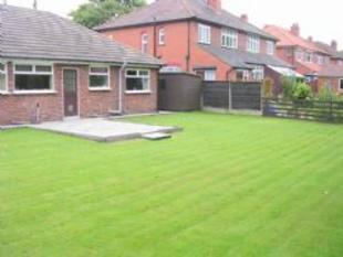
Side access gates lead to the superb rear gardens which are predominately lawned and are extremely secluded, additionally there is a flagged patio area and a timber garden shed together with external security lights.
ADDITIONAL DETAILS:
We are informed by the vendors that the property is in Council Tax Band 'D' payable to Trafford Borough Council and the property's tenure is Freehold and free from Chief rent.
Living Room
Kitchen
Kitchen
Master Bedroom
Rear Garden
Listed by
Stretford
Paul Birtles Ltd
Reference: 9313889
EPC ratings on this postcode
We don't have a matched EPC for this property yet. Below are efficiency scores and details for other addresses on this postcode.
| Address | Current | Potential | Floor area | Age band | Type |
|---|---|---|---|---|---|
| 12, Norwood Road, Stretford, MANCHESTER | 43 | 74 | 154 m² | England and Wales: 1900-1929 | Terraced |
| 18 Norwood Road, Stretford, MANCHESTER | 81 | 94 | 41 m² | England and Wales: 1991-1995 | Flat |
| 18 Norwood Road, Stretford, MANCHESTER | 81 | 94 | 41 m² | England and Wales: 1991-1995 | Flat |
| 18 Norwood Road, Stretford, MANCHESTER | 69 | 70 | 45 m² | England and Wales: 1991-1995 | Flat |
| 18, Norwood Road, Stretford, MANCHESTER | 69 | 78 | 50 m² | England and Wales: 1991-1995 | Flat |
| 18, Norwood Road, Stretford, MANCHESTER | 63 | 72 | 50 m² | England and Wales: 1991-1995 | Flat |
| 18a Norwood Road, Stretford, MANCHESTER | 81 | 89 | 55 m² | England and Wales: 1991-1995 | Flat |
| 18a, Norwood Road, Stretford, MANCHESTER | 77 | 78 | 52 m² | England and Wales: 1991-1995 | Flat |
| 18a, Norwood Road, Stretford, MANCHESTER | 70 | 72 | 52 m² | England and Wales: 1991-1995 | Flat |
| 20 Norwood Road, Stretford, MANCHESTER | 82 | 86 | 48 m² | England and Wales: 2003-2006 | Flat |
| 20 Norwood Road, Stretford, MANCHESTER | 82 | 86 | 48 m² | England and Wales: 2003-2006 | Flat |
| 20 Norwood Road, Stretford, MANCHESTER | 77 | 80 | 48 m² | England and Wales: 1983-1990 | Flat |
| 20, Norwood Road, Stretford, MANCHESTER | 72 | 79 | 50 m² | England and Wales: 1991-1995 | Flat |
| 20a Norwood Road, Stretford, MANCHESTER | 81 | 84 | 42 m² | England and Wales: 1991-1995 | Flat |
| 20a Norwood Road, Stretford, MANCHESTER | 81 | 84 | 42 m² | England and Wales: 1991-1995 | Flat |
Flood risk
Zone: 1
Risk: Low
Job (default Low)
Price history
| Event | Date | Price | % change |
|---|---|---|---|
| Sold | 01/01/2005 (21 years ago) | £315,000 | — |
Source: HM Land Registry Price Paid Data. Crown copyright.
Sold Comparables
Same street and nearby sales within 0.25 miles (last 5 years). Data from Land Registry Price Paid.
| Address | Price | Date | Type |
|---|---|---|---|
| 28 HILLINGDON ROAD, STRETFORD, MANCHESTER, TRAFFORD, GREATER MANCHESTER, M32 8PB | £610,000 | 18/02/2026 | Detached |
| 25 GRANBY ROAD, STRETFORD, MANCHESTER, TRAFFORD, GREATER MANCHESTER, M32 8JL | £565,000 | 25/06/2025 | Detached |
| 25 GRANBY ROAD, STRETFORD, MANCHESTER, TRAFFORD, GREATER MANCHESTER, M32 8JL | £565,000 | 25/06/2025 | Detached |
| 36 NORWOOD ROAD, STRETFORD, MANCHESTER, TRAFFORD, GREATER MANCHESTER, M32 8PW | £683,000 | 13/06/2025 | Detached |
| 33 CROMWELL ROAD, STRETFORD, MANCHESTER, TRAFFORD, GREATER MANCHESTER, M32 8GH | £448,500 | 20/12/2023 | Detached |
| 56 CROMWELL ROAD, STRETFORD, MANCHESTER, TRAFFORD, GREATER MANCHESTER, M32 8QJ | £715,000 | 20/10/2023 | Detached |
| 67 HILLINGDON ROAD, STRETFORD, MANCHESTER, TRAFFORD, GREATER MANCHESTER, M32 8PH | £509,000 | 27/09/2022 | Detached |
| 80 EDGE LANE, STRETFORD, MANCHESTER, TRAFFORD, GREATER MANCHESTER, M32 8JP | £613,000 | 08/09/2022 | Detached |
| 9 TRURO AVENUE, STRETFORD, MANCHESTER, TRAFFORD, GREATER MANCHESTER, M32 8PF | £450,000 | 24/06/2022 | Detached |
Area average: £573,167 (9 sales)
Capital growth trend
Land Registry outcode average: last 12 months vs 5y and 10y ago (from sold prices).
House Price Index (HM Land Registry — official index, not sold-price averages): Trafford. Series: Detached. As of March 2026.
Rental Range
Estimated market rent for Trafford. Low = conservative, Realistic = average, Optimistic = best case.
Based on Local Authority from postcode lookup → Trafford.
LHA (30th percentile) floor for West Pennine: £504/mo (Apr 2025 – Mar 2026)
Location
Address
Norwood Road
Nearby
Nearest stations, universities and amenities (distance from property).
| Type | Name | Distance |
|---|---|---|
| Bus stop | Stretford, Edge Lane / near Norwood Road | 0.1 miles |
| Bus stop | Stretford, Edge Lane / opposite Norwood Road | 0.1 miles |
| Shop | Cadbury | 0.2 miles |
| Shop | Londis | 0.3 miles |
| Train station | Trafford Park | 0.8 miles |
| University | University Academy 92 | 1.0 miles |
| Train station | Humphrey Park | 1.3 miles |
| University | University of Salford | 1.9 miles |
| Hospital | Spire Manchester Hospital | 2.4 miles |
| Hospital | Withington Community Hospital | 2.6 miles |
Street-level crime
| Category | Count |
|---|---|
| Total incidents | 0 |
Within 1 mile during Apr 2026. Source: data.police.uk (England & Wales).
Schools nearby
Nearest open schools with Ofsted ratings (England). Closed schools are not shown. Data from Get Information about Schools and Ofsted.
| Name | Type | Distance | Ofsted |
|---|---|---|---|
| Stretford Grammar School | Secondary | 0.2 miles | Good — 14 May 2015 |
| Longford Park School | Other | 0.2 miles | Requires improvement — 9 Jun 2024 |
| Victoria Park Junior School | Primary | 0.4 miles | Good — 9 May 2024 |
| St Ann's RC Primary School | Primary | 0.4 miles | Good — 17 Mar 2020 |
| Victoria Park Infant School | Primary | 0.5 miles | Good — 30 Jan 2023 |
Rental Comparables
Loading rental comparables for this postcode. Refresh in a few minutes.
Rent-driven metrics
Based on Area rent estimate.
- Rent ratio — Monthly rent ÷ purchase price (1% rule). 1%+ = strong, 0.8–1% = okay, <0.8% = weak for cashflow.
- Max investor price — Rent ÷ 0.8%; the price at which rent would be 0.8% of price (Stoke-style target).
- Target investor price — Rent ÷ 1%; the price at which rent would be 1% of price (strong cashflow band).
- Gross yield — Annual rent as % of purchase price (no costs).
Enter House Number
Enter the house number to help us retrieve more accurate pricing history and property data.
Please log in to submit or correct the house number for this listing.
Log in to continue