Greenbank Road
Burslem, Stoke-on-Trent, ST6, ST6 7EX
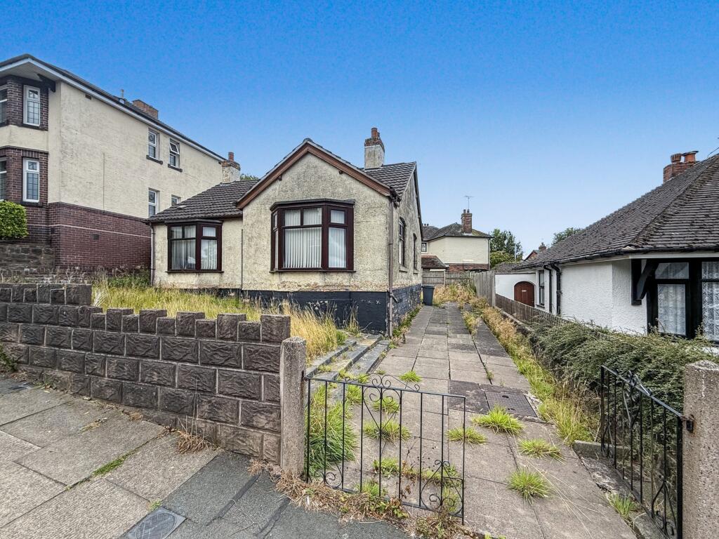
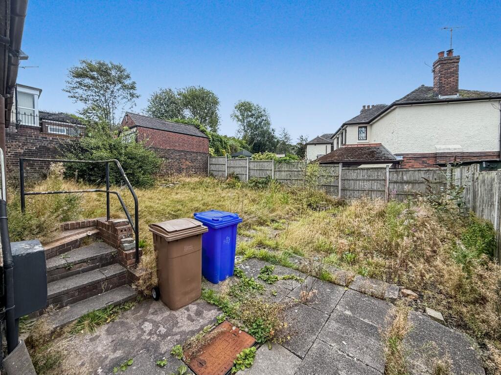
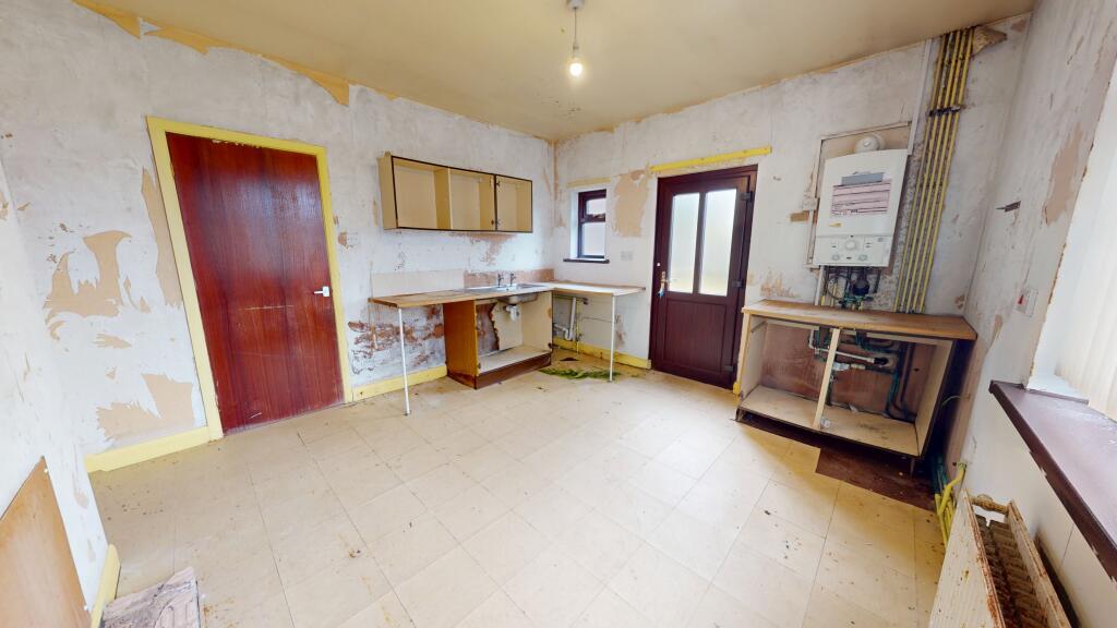
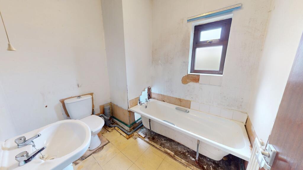
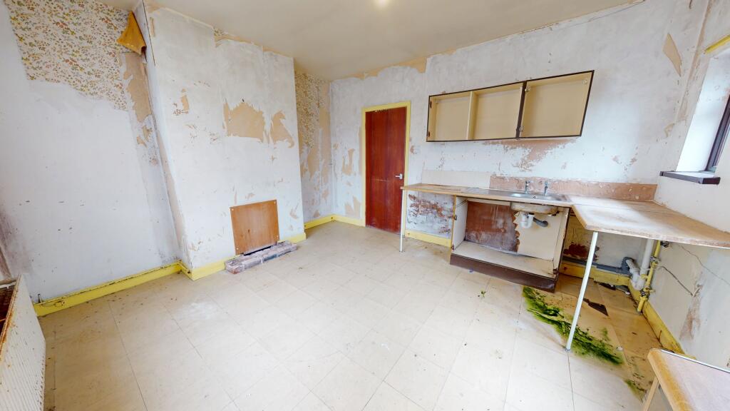
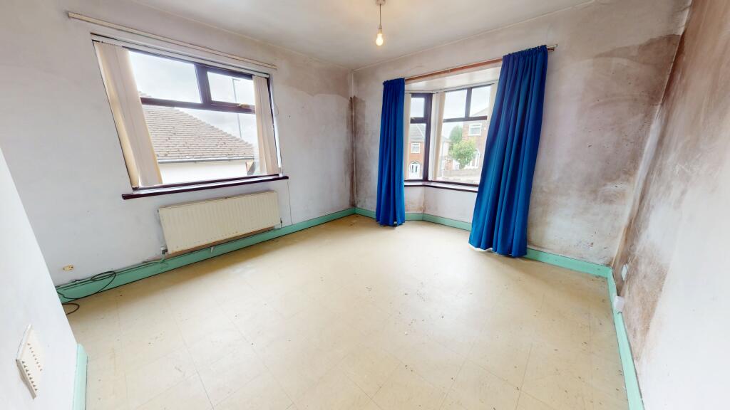
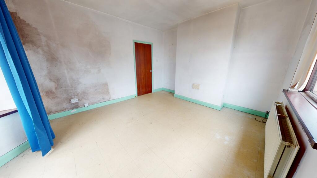
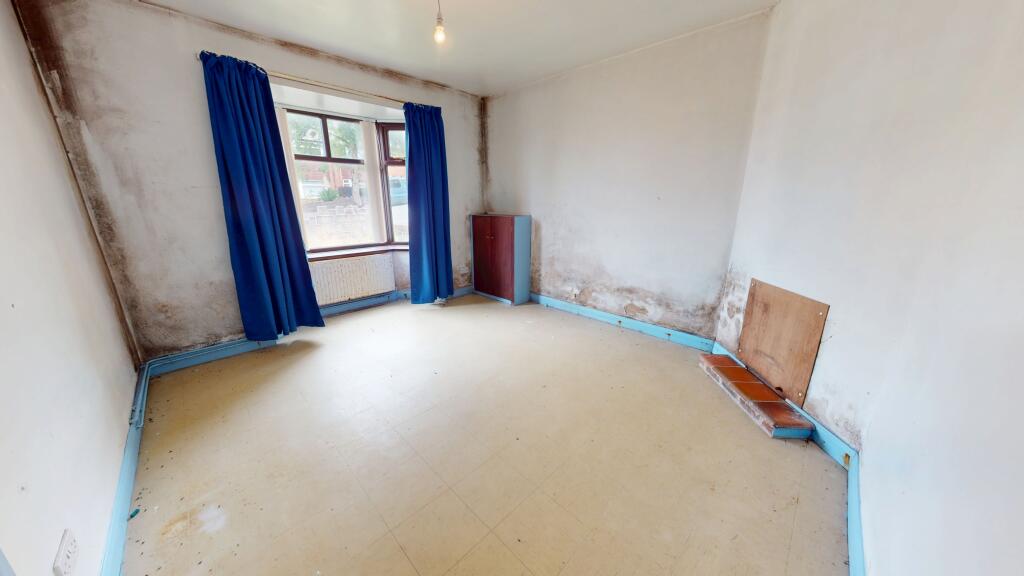
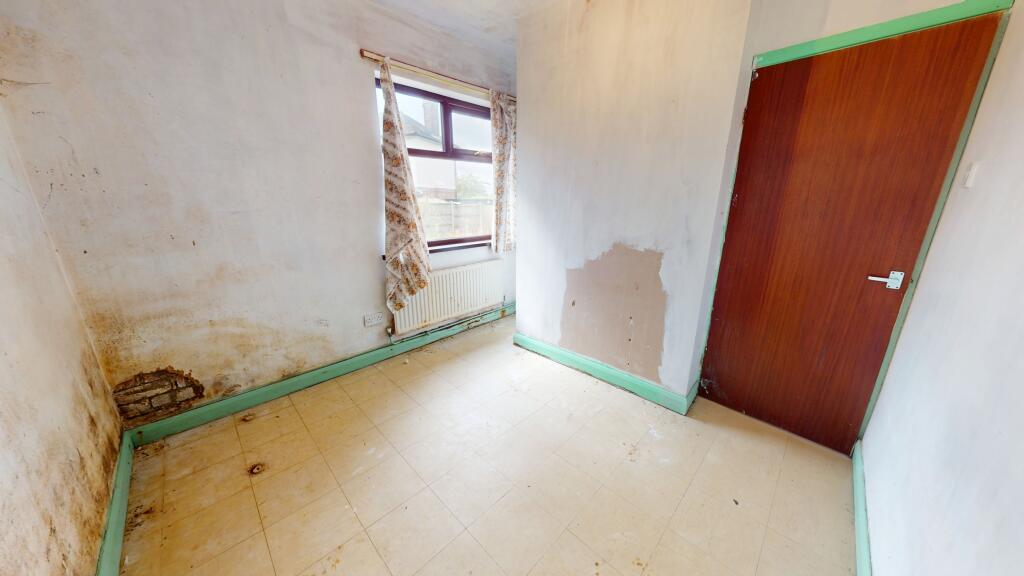
Photo 1 Photo 2 Photo 3 Photo 4 Photo 5 Photo 6 Photo 7 Photo 8 Photo 9
/ 9
Property details
Tenure
FREEHOLD
Council tax band
C
Local average
£256,517 (-41.5%)
Deprivation
Decile 5 (16,715 of 33,755)
Street crime
474 incidents within 1 mile (Apr 2026)
Key features
- NO CHAIN
- Two bedroom detached bungalow
- Requiring renovation
- Kitchen/diner
- Gated driveway
- Front & rear garden
- Bay-fronted lounge
- Entrance hallway
- Double glazing & gas central heating
- Close to Haywood Hospital
Additional details
- Heating
- Gas central
- Parking
- Driveway
- Garden
- Private garden
- Listed property
- No
Description
As you enter the property into the hallway you will find the lounge to the right which has a large bay window and a window to the side allowing plenty of natural light in. On the other side of the hallway is the front facing master bedroom which is a brilliant size. Next is the open plan kitchen diner which provides access into the garden. Completing the property there is a further bedroom and the family bathroom.
The front of the property provides off road parking and access to the rear.
EPC rating: D. Tenure: Freehold,
Listed by
Stoke-On-Trent
The Property Franchise Group
Reference: 166497242
EPC ratings on this postcode
We don't have a matched EPC for this property yet. Below are efficiency scores and details for other addresses on this postcode.
| Address | Current | Potential | Floor area | Age band | Type |
|---|---|---|---|---|---|
| 11, Greenbank Road, STOKE-ON-TRENT | 52 | 79 | 90 m² | England and Wales: 1930-1949 | Detached |
| 13, Greenbank Road, STOKE-ON-TRENT | 56 | 75 | 97 m² | England and Wales: 1930-1949 | Detached |
| 17 Greenbank Road, STOKE-ON-TRENT | 67 | 80 | 97 m² | England and Wales: 1950-1966 | Detached |
| 17, Greenbank Road, STOKE-ON-TRENT | 54 | 79 | 104 m² | England and Wales: 1930-1949 | Detached |
| 25 Greenbank Road, STOKE-ON-TRENT | 63 | 76 | 62 m² | England and Wales: 1930-1949 | Detached |
| 25, Greenbank Road, STOKE-ON-TRENT | 40 | 87 | 62 m² | England and Wales: 1900-1929 | Detached |
| 3, Greenbank Road, STOKE-ON-TRENT | 57 | 81 | 79 m² | England and Wales: 1930-1949 | Detached |
| 31, Greenbank Road, STOKE-ON-TRENT | 57 | 83 | 79 m² | England and Wales: 1900-1929 | Detached |
| 31, Greenbank Road, STOKE-ON-TRENT | 53 | 81 | 79 m² | England and Wales: 1900-1929 | Detached |
| 35, Greenbank Road, STOKE-ON-TRENT | 55 | 83 | 95 m² | England and Wales: 1930-1949 | Detached |
| 35, Greenbank Road, STOKE-ON-TRENT | 40 | 83 | 95 m² | England and Wales: 1930-1949 | Detached |
| 41 GREENBANK ROAD, STOKE-ON-TRENT | 61 | 82 | 126 m² | England and Wales: 1930-1949 | Detached |
| 41, Greenbank Road, STOKE-ON-TRENT | 45 | 72 | 111 m² | England and Wales: 1930-1949 | Detached |
| 45 Greenbank Road, STOKE-ON-TRENT | 59 | 72 | 181 m² | England and Wales: 1950-1966 | Detached |
| 45, Greenbank Road, STOKE-ON-TRENT | 53 | 66 | 189 m² | England and Wales: 1967-1975 | Detached |
Flood risk
Zone: 1
Risk: Low
Job (default Low)
Floorplans

Floorplan
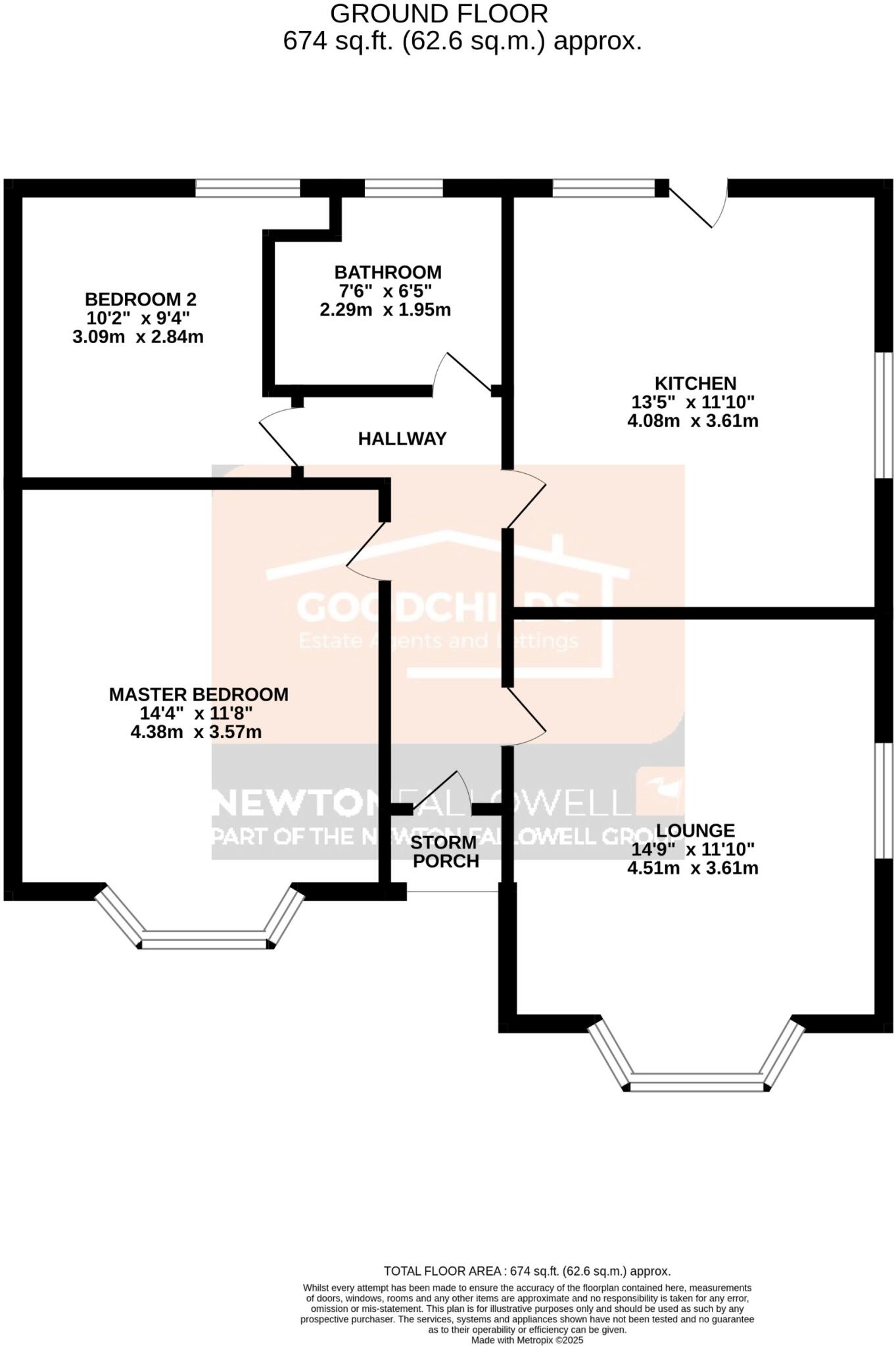
Floorplan
Price history
No sales history found for this property in Land Registry Price Paid data.
Sold Comparables
Same street and nearby sales within 0.25 miles (last 5 years). Data from Land Registry Price Paid.
| Address | Price | Date | Type |
|---|---|---|---|
| 13 EASTWOOD AVENUE, STOKE-ON-TRENT, ST6 7JP | £300,000 | 14/11/2025 | Detached |
| Same street 17 GREENBANK ROAD, STOKE-ON-TRENT, ST6 7EX | £187,000 | 08/09/2023 | Semi-detached |
| Same street 9 GREENBANK ROAD, STOKE-ON-TRENT, ST6 7EX | £120,000 | 21/12/2022 | Semi-detached |
| 68 GREENBANK ROAD, STOKE-ON-TRENT, ST6 7EY | £285,000 | 09/11/2022 | Detached |
| 607 HIGH LANE, STOKE-ON-TRENT, ST6 7EN | £280,000 | 18/10/2022 | Detached |
| 14 DUNWOOD DRIVE, STOKE-ON-TRENT, ST6 7BW | £182,500 | 19/05/2022 | Detached |
| Same street 41 GREENBANK ROAD, STOKE-ON-TRENT, ST6 7EX | £249,950 | 08/03/2022 | Detached |
| 23 EASTWOOD AVENUE, STOKE-ON-TRENT, ST6 7JP | £336,000 | 25/11/2021 | Detached |
Street average: £185,650 (3 sales)
Area average: £276,700 (5 sales)
Capital growth trend
Land Registry outcode average: last 12 months vs 5y and 10y ago (from sold prices).
House Price Index (HM Land Registry — official index, not sold-price averages): Stoke-on-Trent. Series: Detached. As of March 2026.
Rental Range
Estimated market rent for Stoke-on-Trent. Low = conservative, Realistic = average, Optimistic = best case.
Based on Local Authority from postcode lookup → Stoke-on-Trent.
LHA (30th percentile) floor for Staffordshire North: £479/mo (Apr 2025 – Mar 2026)
Location
Address
Norton Avenue
Nearby
Nearest stations, universities and amenities (distance from property).
| Type | Name | Distance |
|---|---|---|
| Bus stop | Greenbank Road | 0.1 miles |
| Bus stop | Norton Avenue | 0.1 miles |
| Hospital | Haywood Hospital | 0.2 miles |
| Hospital | Haywood Hospital Walk-in Centre | 0.3 miles |
| Shop | Simply Local | 0.3 miles |
| Shop | Salon Chloe | 0.3 miles |
| Train station | Longport | 1.6 miles |
| Train station | Kidsgrove | 2.8 miles |
| University | University of Staffordshire Stoke Campus | 3.5 miles |
Street-level crime
| Category | Count |
|---|---|
| Violence and sexual offences | 154 |
| Anti-social behaviour | 101 |
| Criminal damage and arson | 38 |
| Vehicle crime | 38 |
| Other theft | 32 |
| Shoplifting | 27 |
| Public order | 25 |
| Burglary | 17 |
| Drugs | 17 |
| Robbery | 10 |
| Other crime | 7 |
| Possession of weapons | 5 |
| Bicycle theft | 2 |
| Theft from the person | 1 |
| Total incidents | 474 |
Within 1 mile during Apr 2026. Source: data.police.uk (England & Wales).
Schools nearby
Nearest open schools with Ofsted ratings (England). Closed schools are not shown. Data from Get Information about Schools and Ofsted.
| Name | Type | Distance | Ofsted |
|---|---|---|---|
| Mill Hill Primary Academy | Primary | 0.3 miles | Outstanding — 24 Jan 2024 |
| Haywood Academy | Secondary | 0.4 miles | Good — 14 Jun 2023 |
| St Wilfrid's Catholic Primary School | Primary | 0.4 miles | Good — 12 Jun 2017 |
| St Margaret Ward Catholic Academy | Secondary | 0.6 miles | Good — 4 Mar 2013 |
| Burnwood Community Primary School | Primary | 0.7 miles | Good — 9 Nov 2015 |
Rental Comparables
Residential lets from OpenRent and Rightmove for the area (same bedroom count). Use to validate rent estimates. Student lets are excluded.
Average rent: £737/mo (32 listings)
Rent-driven metrics
Based on OpenRent comparables.
- Rent ratio — Monthly rent ÷ purchase price (1% rule). 1%+ = strong, 0.8–1% = okay, <0.8% = weak for cashflow.
- Max investor price — Rent ÷ 0.8%; the price at which rent would be 0.8% of price (Stoke-style target).
- Target investor price — Rent ÷ 1%; the price at which rent would be 1% of price (strong cashflow band).
- Gross yield — Annual rent as % of purchase price (no costs).
- Cost-to-rent — Price ÷ annual rent (from OpenRent comparables). Under 14× = strong, 14–16× = acceptable, 17×+ = compressed.
- Cashflow — Rent minus mortgage, 10% maintenance, £25/mo compliance. Assumes 75% LTV, 3.95% APR (5yr fixed), 25yr term.
- ROI — Annual profit ÷ cash in (deposit + 4% purchase costs).
Enter House Number
Enter the house number to help us retrieve more accurate pricing history and property data.
Please log in to submit or correct the house number for this listing.
Log in to continue