9
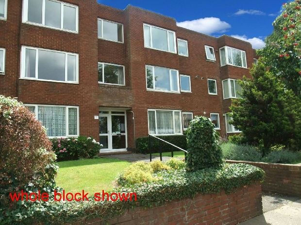
PHIPPSVILLE COURT, ST MATTHEWS PARADE, NORTHAMPTON, NORTHAMPTONSHIRE NN2 7JW
£109,995
Property details
Tenure
LEASEHOLD
Last sold
£104,000 Apr 2012
Local average
£133,400 (-17.5%)
Deprivation
Decile 3 (8,768 of 33,755)
Street crime
506 incidents within 1 mile (Apr 2026)
Key features
- 2 bedrooms
- Flat
Additional details
- Parking
- Yes
Description
.
Hall:
"L" shaped Hallway approached via wooden door, small recess storage area, storage cupboard and doors leading to Lounge, Bathroom, WC, Bedroom One and Bedroom Two
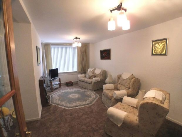
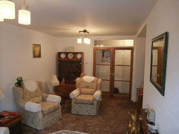
Lounge:
5.64m (18ft 6in) x 3.05m (10ft 0in)
Double glazed doors leading to Lounge with double glazed window to the front elevation over looking St Matthews Church, radiator, electric fire with surround, TV aerial and Telephone points
Lounge Alternate
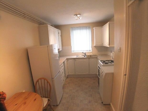
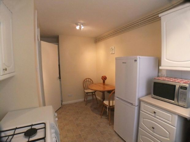
Kitchen Breakfast Room:
4.14m (13ft 7in) x 2.49m (8ft 2in)
A modern fitted Kitchen with a range of base and wall mounted units, single sink with drainer, gas oven and hob, space for fridge freezer and plumbing for automatic washing machine. Radiator,double glazed window to front elevation
Kitchen Breakfast Alternate
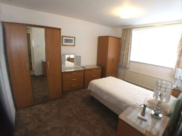
Bedroom 1:
4.01m (13ft 2in) x 3.05m (10ft 0in)
Double glazed window to the rear elevation, radiator and fitted wardrobes
Bedroom 2:
2.77m (9ft 1in) x 2.49m (8ft 2in)
Bedroom Tow/Dining Room with double glazed window to the rear elevation
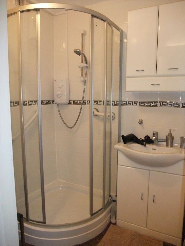
Bathroom:
1.68m (5ft 6in) x 1.55m (5ft 1in)
Fully tiled bathroom comprising of tiled corner Shower Cubicle, low level WC, Wash Hand Basin set in vanity unit with matching storage cupboard above
Outside:
Single garage in a block and residents parking
Additional information:
Lease - 99 year Lease from 1973
Service Charge - £457.60 per half year
Ground Rent - £14.00 per half year (if the lease is renewed Ground Rent is not applicable)
Listed by
Northampton Sales
Countrywide UK Sales - Connells
Reference: 36424307
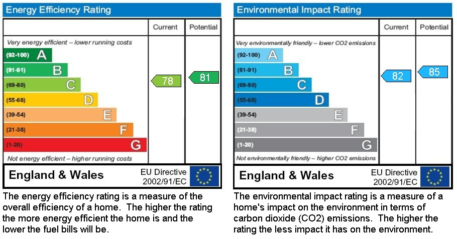
EPC Rating & Upgrade Cost
Fetching EPC data… Refresh this page in a moment.
Flood risk
Zone: 1
Risk: Low
Job (default Low)
Price history
| Event | Date | Price | % change |
|---|---|---|---|
| Sold | 30/04/2012 (14 years ago) | £104,000 | — |
Source: HM Land Registry Price Paid Data. Crown copyright.
Sold Comparables
Same street and nearby sales within 0.25 miles (last 5 years). Data from Land Registry Price Paid.
| Address | Price | Date | Type |
|---|---|---|---|
| BRADFORD HOUSE, 44 FLAT 9 KINGSLEY ROAD, NORTHAMPTON, WEST NORTHAMPTONSHIRE, NN2 7BL | £150,000 | 19/12/2025 | Flat |
| PHIPPSVILLE COURT 7 ST MATTHEWS PARADE, NORTHAMPTON, WEST NORTHAMPTONSHIRE, NN2 7JW | £135,000 | 06/06/2025 | Flat |
| PHIPPSVILLE COURT 20 ST MATTHEWS PARADE, NORTHAMPTON, WEST NORTHAMPTONSHIRE, NN2 7JW | £114,000 | 19/05/2023 | Flat |
| PHIPPSVILLE COURT 22 ST MATTHEWS PARADE, NORTHAMPTON, WEST NORTHAMPTONSHIRE, NN2 7JW | £100,000 | 31/01/2023 | Flat |
| 4 FLAT 5 THE DRIVE, NORTHAMPTON, WEST NORTHAMPTONSHIRE, NN1 4RY | £166,000 | 25/11/2022 | Flat |
| 17 FLAT 3 THE DRIVE, NORTHAMPTON, WEST NORTHAMPTONSHIRE, NN1 4RY | £169,000 | 18/11/2022 | Flat |
| BRADFORD HOUSE, 44 FLAT 1 KINGSLEY ROAD, NORTHAMPTON, WEST NORTHAMPTONSHIRE, NN2 7BL | £150,000 | 15/07/2022 | Flat |
| 4 FLAT 6 THE DRIVE, NORTHAMPTON, WEST NORTHAMPTONSHIRE, NN1 4RY | £150,004 | 03/09/2021 | Flat |
Area average: £141,751 (8 sales)
Capital growth trend
Land Registry outcode average: last 12 months vs 5y and 10y ago (from sold prices).
House Price Index (HM Land Registry — official index, not sold-price averages): West Northamptonshire. Series: Flats and maisonettes. As of March 2026.
Rental Range
Estimated market rent for West Northamptonshire. Low = conservative, Realistic = average, Optimistic = best case.
Based on Local Authority from postcode lookup → West Northamptonshire.
LHA (30th percentile) floor for Leicester: £648/mo (Apr 2025 – Mar 2026)
Location
Nearby
Nearest stations, universities and amenities (distance from property).
| Type | Name | Distance |
|---|---|---|
| Bus stop | Unknown | 0.0 miles |
| Shop | Georgie's | 0.0 miles |
| Shop | Capital | 0.0 miles |
| Hospital | St Matthews Hospital | 0.1 miles |
| University | University of Northampton St Georges Avenue | 0.6 miles |
| Hospital | Manfield Health Campus | 1.1 miles |
| University | University of Northampton - School of Podiatry | 1.2 miles |
| Train station | Northampton | 1.6 miles |
| Train station | Boughton | 2.7 miles |
Street-level crime
| Category | Count |
|---|---|
| Violence and sexual offences | 181 |
| Anti-social behaviour | 140 |
| Public order | 30 |
| Drugs | 25 |
| Other theft | 25 |
| Vehicle crime | 24 |
| Criminal damage and arson | 23 |
| Burglary | 19 |
| Robbery | 14 |
| Shoplifting | 10 |
| Possession of weapons | 8 |
| Other crime | 3 |
| Bicycle theft | 2 |
| Theft from the person | 2 |
| Total incidents | 506 |
Within 1 mile during Apr 2026. Source: data.police.uk (England & Wales).
Schools nearby
Nearest open schools with Ofsted ratings (England). Closed schools are not shown. Data from Get Information about Schools and Ofsted.
| Name | Type | Distance | Ofsted |
|---|---|---|---|
| Wallace Road Nursery School | Nursery | 0.3 miles | Good — 24 Jul 2022 |
| Kingsley Primary School | Primary | 0.4 miles | Good — 24 Jul 2023 |
| Cedar Road Primary School | Primary | 0.4 miles | Good — 3 Jul 2023 |
| Fairfields School | Other | 0.5 miles | Outstanding — 20 Mar 2014 |
| Stimpson Avenue Academy | Primary | 0.5 miles | Good — 19 Sep 2023 |
Rental Comparables
Loading rental comparables for this postcode. Refresh in a few minutes.
Rent-driven metrics
Based on Area rent estimate.
- Rent ratio — Monthly rent ÷ purchase price (1% rule). 1%+ = strong, 0.8–1% = okay, <0.8% = weak for cashflow.
- Max investor price — Rent ÷ 0.8%; the price at which rent would be 0.8% of price (Stoke-style target).
- Target investor price — Rent ÷ 1%; the price at which rent would be 1% of price (strong cashflow band).
- Gross yield — Annual rent as % of purchase price (no costs).