1 SWAN LANE
ASHFORD, SELLINDGE, KENT TN25 6EP
Sale by Tender

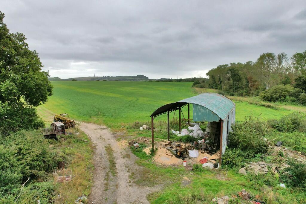
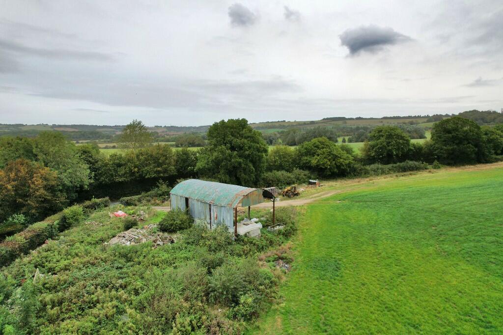
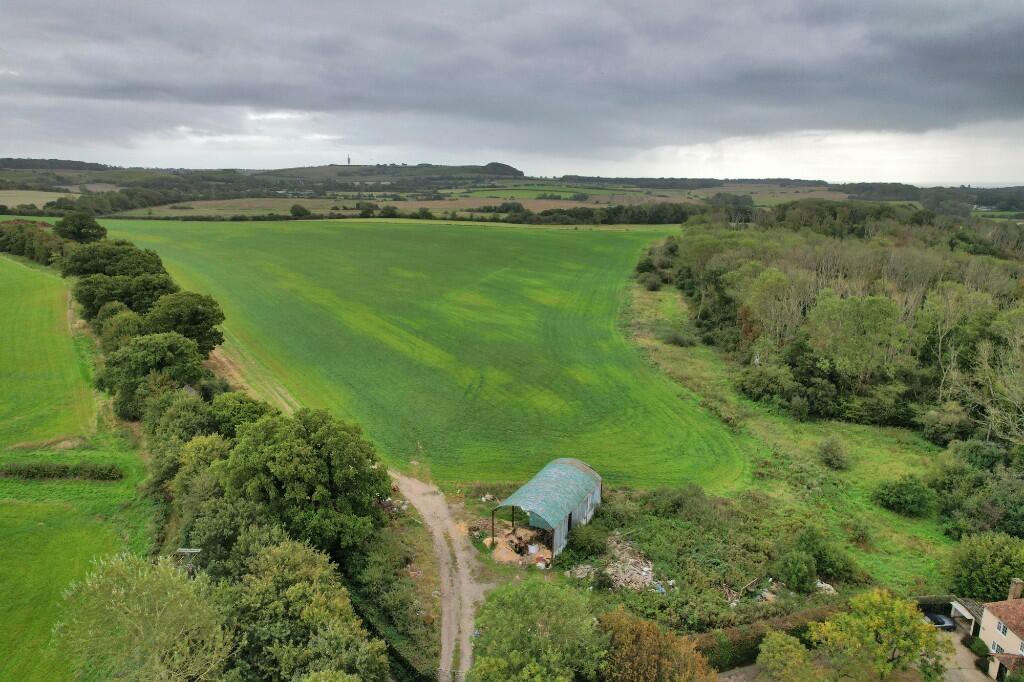
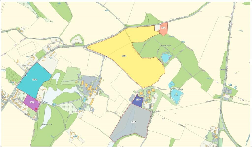
Photo 1 Photo 2 Photo 3 Photo 4 Photo 5
/ 5
Property details
Floor area
108 m²
EPC rating
F
Year built
England and Wales: 1900-1929
Last sold
£89,000 Jan 1997
Price per m²
£880/m²
Local average
£467,700 (-79.7%)
Deprivation
Decile 4 (12,380 of 33,755)
Street crime
3 incidents within 1 mile (Mar 2026)
Description
Located to the south of Blindhouse Lane the Dutch Barn comprises a three bay steel framed barn part clad in corrugated tin measuring approximately 104m2. The Barn is in a dilapidated state and stands within a curtilage of approximately 1.40 acres with direct frontage to Blindhouse Lane where there is a gated access. The Barn offers the potential for future conversion subject to the necessary planning consents. We understand the building is not currently connected to services although we have been informed that electricity and water services are available close by.
FOR SALE BY INFORMAL TENDER - CLOSING 8TH MARCH 2024
Listed by
Heathfield
BTF Partnership LLP
Reference: 144216719
EPC Rating & Upgrade Cost
Current rating: F
Potential rating: E
Inspection date: 03/10/2024
Current heating cost: £1,813/year
Potential heating cost: £1,595/year
Est. upgrade cost to C: £16,500
Recommendations
- Floor insulation (suspended floor) (£800 - £1,200)
- Floor insulation (solid floor) (£4,000 - £6,000)
- Solar water heating (£4,000 - £6,000)
- High performance external doors (£1,000)
- Solar photovoltaic panels, 2.5 kWp (£3,500 - £5,500)
Flood risk
Zone: 1
Risk: Low
Job (default Low)
Price history
| Event | Date | Price | % change |
|---|---|---|---|
| Sold | 03/01/1997 (29 years ago) | £89,000 | — |
Source: HM Land Registry Price Paid Data. Crown copyright.
Sold Comparables
Same street and nearby sales within 0.25 miles (last 5 years). Data from Land Registry Price Paid.
| Address | Price | Date | Type |
|---|---|---|---|
| Same street 5 SWAN LANE, SELLINDGE, ASHFORD, FOLKESTONE AND HYTHE, KENT, TN25 6EP | £380,000 | 17/11/2023 | Semi-detached |
| NORWEST HOLST-CRISPIN & BOARST STANFORD INTERSECTION, STANFORD, ASHFORD, FOLKESTONE AND HYTHE, KENT, TN25 6GH | £8,500,000 | 19/12/2022 | Other |
| IVY COTTAGE, 60 SWAN LANE, SELLINDGE, ASHFORD, FOLKESTONE AND HYTHE, KENT, TN25 6HB | £400,000 | 09/05/2022 | Other |
| Same street 11 SWAN LANE, SELLINDGE, ASHFORD, FOLKESTONE AND HYTHE, KENT, TN25 6EP | £405,000 | 24/09/2021 | Semi-detached |
Street average: £392,500 (2 sales)
Area average: £4,450,000 (2 sales)
Capital growth trend
Land Registry outcode average: last 12 months vs 5y and 10y ago (from sold prices).
House Price Index (HM Land Registry — official index, not sold-price averages): Folkestone and Hythe. Series: All dwelling types. As of February 2026.
Rental Range
Estimated market rent for Folkestone and Hythe. Low = conservative, Realistic = average, Optimistic = best case.
Based on Local Authority from postcode lookup → Folkestone and Hythe.
LHA (30th percentile) floor for Ashford: Apr 2025 – Mar 2026
Location
Nearby
Nearest stations, universities and amenities (distance from property).
| Type | Name | Distance |
|---|---|---|
| Bus stop | Downs Way | 0.0 miles |
| Shop | Sellindge Premier | 0.1 miles |
| Train station | Westenhanger | 1.5 miles |
| Shop | WHSmith | 1.8 miles |
| Train station | Sandling | 2.8 miles |
| Hospital | William Harvey Hospital (Ashford) | 4.6 miles |
| Hospital | WIlliam Harvey Hospital | 4.7 miles |
Street-level crime
| Category | Count |
|---|---|
| Criminal damage and arson | 1 |
| Other crime | 1 |
| Violence and sexual offences | 1 |
| Total incidents | 3 |
Within 1 mile during Mar 2026. Source: data.police.uk (England & Wales).
Schools nearby
Nearest open schools with Ofsted ratings (England). Closed schools are not shown. Data from Get Information about Schools and Ofsted.
| Name | Type | Distance | Ofsted |
|---|---|---|---|
| Sellindge Primary School | Primary | 0.2 miles | Good — 16 Mar 2023 |
| Lympne Church of England Primary School | Primary | 2.1 miles | Good — 18 Apr 2012 |
| Smeeth Community Primary School | Primary | 2.1 miles | Good — 14 Sep 2023 |
| Brabourne Church of England Primary School | Primary | 2.4 miles | Good — 11 Nov 2013 |
| Caldecott Foundation School | Other | 2.5 miles | Good — 5 Apr 2017 |
Rental Comparables
Loading rental comparables for this postcode. Refresh in a few minutes.
Rent-driven metrics
Based on Area rent estimate.
- Rent ratio — Monthly rent ÷ purchase price (1% rule). 1%+ = strong, 0.8–1% = okay, <0.8% = weak for cashflow.
- Max investor price — Rent ÷ 0.8%; the price at which rent would be 0.8% of price (Stoke-style target).
- Target investor price — Rent ÷ 1%; the price at which rent would be 1% of price (strong cashflow band).
- Gross yield — Annual rent as % of purchase price (no costs).