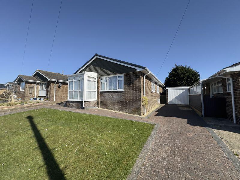
7 COOK AVENUE
NEWPORT, ISLE OF WIGHT PO30 2LL
£325,000
Property details
Tenure
FREEHOLD
Floor area
82 m²
Council tax band
D
Last sold
£310,000 Aug 2025
Local average
£411,455 (-21%)
Deprivation
Decile 6 (16,937 of 33,755)
Street crime
221 incidents within 1 mile (Apr 2026)
Key features
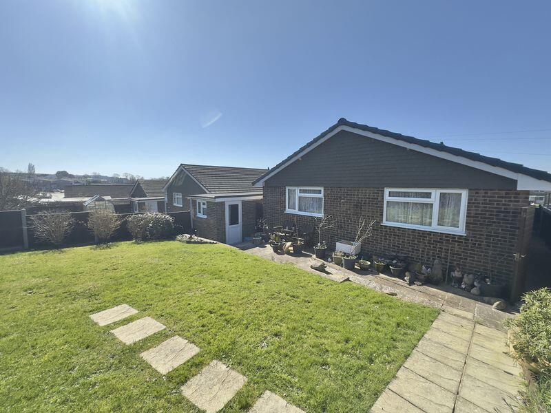
- CHAIN FREE
- DETACHED BUNGALOW
- OFF ROAD PARKING
- GARAGE
- WALKING DISTANCE TO TOWN CENTRE
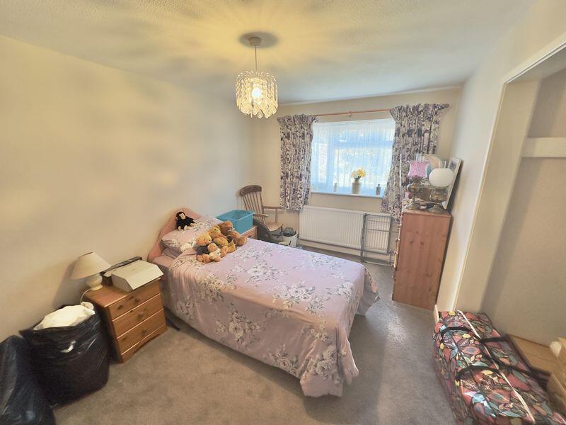
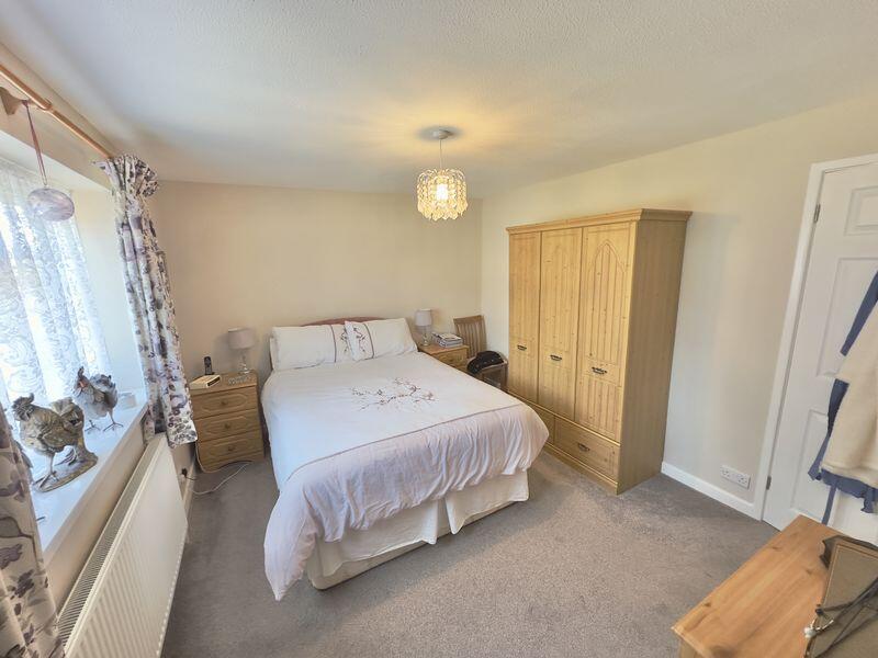
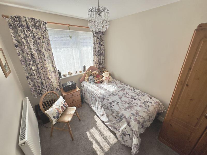
- THREE BEDROOMS
Additional details
- Parking
- Yes
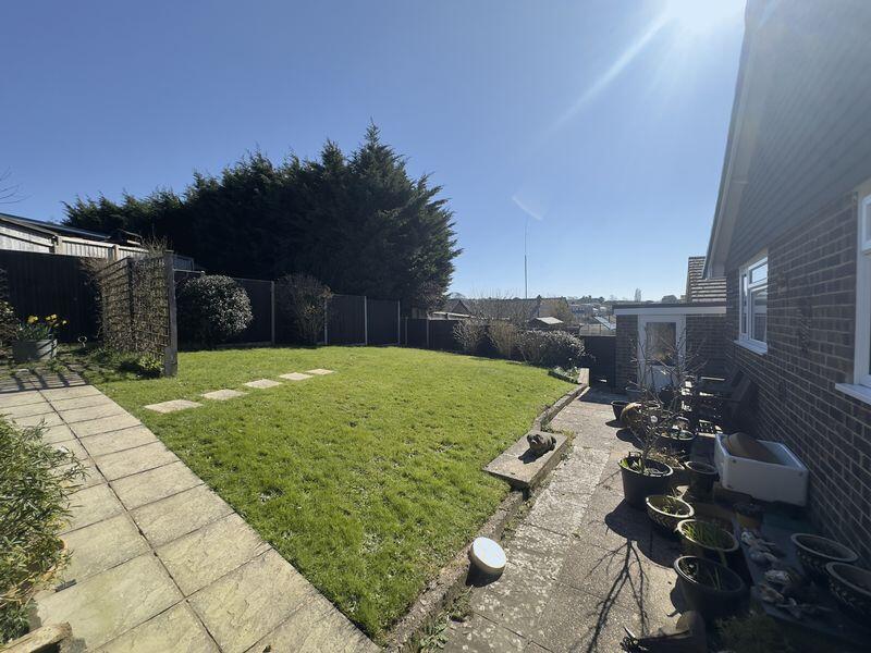
- Garden
- Yes
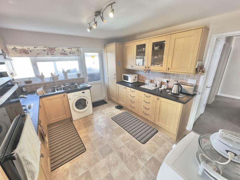
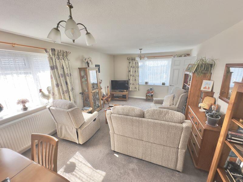
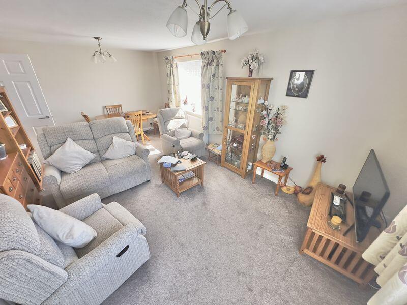
Description
Listed by
Newport
Red Squirrel Property Shop
Reference: 161720813
EPC Rating & Upgrade Cost
Fetching EPC data… Refresh this page in a moment.
Flood risk
Zone: 1
Risk: Low
Job (default Low)
Floorplans
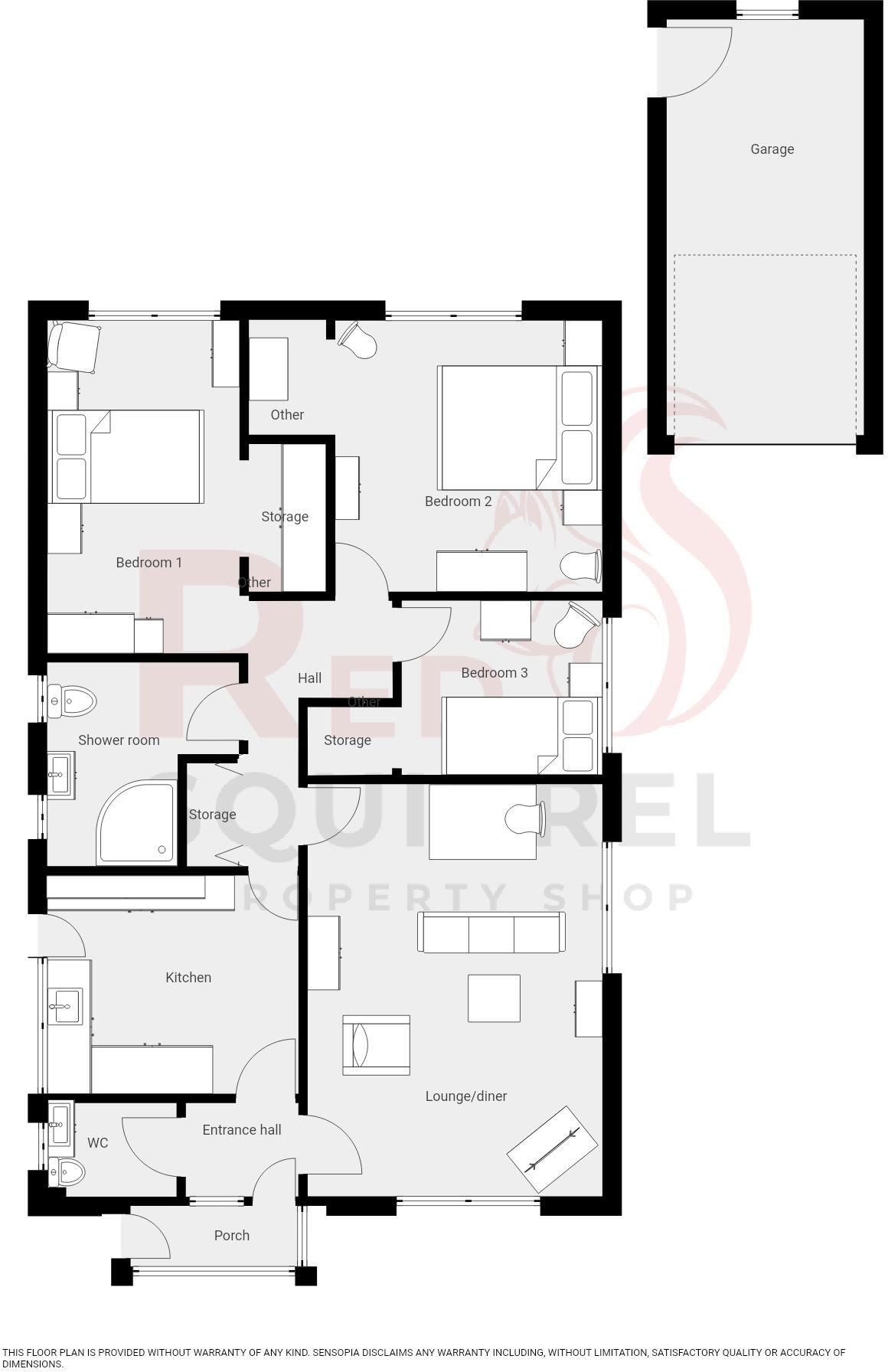
Floorplan 1
EPC Graphs
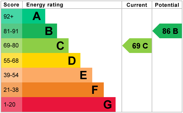
Energy Performance Certificate Graph
FENSA Certificates
This property has 2 FENSA certificate(s) on record, indicating window/door installations by FENSA-approved installers.
FENSA Certificate #11661124
Property Details
Street: 7 Cook Avenue
Town: NEWPORT
Postcode: PO30 2LL
Installation Details
Items: 10 windows and 1 door
Certificate Issued: 06/06/2016
Work Completed: 29/03/2016
This certificate data was retrieved from FENSA's database
FENSA Certificate #13137880
Property Details
Street: 7 Cook Avenue
Town: NEWPORT
Postcode: PO30 2LL
Installation Details
Items: 1 window and 1 door
Certificate Issued: 17/09/2018
Work Completed: 15/08/2018
This certificate data was retrieved from FENSA's database
What is FENSA? FENSA (Fenestration Self-Assessment Scheme) is a government-authorised scheme that monitors building regulation compliance for replacement windows and doors. Certificates indicate that work was completed by FENSA-approved installers.
Price history
75% since 2016
| Event | Date | Price | % change |
|---|---|---|---|
| Sold | 01/08/2025 (10 months ago) | £310,000 | +74.6% |
| Sold | 25/01/2016 (10 years ago) | £177,500 | — |
Source: HM Land Registry Price Paid Data. Crown copyright.
Sold Comparables
Same street and nearby sales within 0.25 miles (last 5 years). Data from Land Registry Price Paid.
| Address | Price | Date | Type |
|---|---|---|---|
| 16 COOPER ROAD, NEWPORT, ISLE OF WIGHT, PO30 2LR | £292,000 | 05/01/2026 | Detached |
| 18 VICTORIA ROAD, NEWPORT, ISLE OF WIGHT, PO30 2HA | £257,000 | 24/11/2023 | Detached |
| 39 STAPLERS ROAD, NEWPORT, ISLE OF WIGHT, PO30 2DE | £325,000 | 03/11/2023 | Detached |
| 14 GREENWOOD WALK, NEWPORT, ISLE OF WIGHT, PO30 2JS | £245,000 | 23/10/2023 | Detached |
| 10 ATKINSON DRIVE, NEWPORT, ISLE OF WIGHT, PO30 2LH | £290,000 | 30/08/2023 | Detached |
| 18 VICTORIA ROAD, NEWPORT, ISLE OF WIGHT, PO30 2HA | £180,000 | 25/08/2023 | Detached |
| Same street 1 COOK AVENUE, NEWPORT, ISLE OF WIGHT, PO30 2LL | £240,000 | 13/07/2023 | Semi-detached |
| 14 BELLECROFT DRIVE, NEWPORT, ISLE OF WIGHT, PO30 2JD | £265,000 | 17/03/2023 | Detached |
| 15 COOPER ROAD, NEWPORT, ISLE OF WIGHT, PO30 2LR | £297,500 | 20/12/2022 | Detached |
| Same street 22 COOK AVENUE, NEWPORT, ISLE OF WIGHT, PO30 2LL | £150,000 | 06/12/2022 | Flat |
| 23 CYNTHIA GROVE, NEWPORT, ISLE OF WIGHT, PO30 2JA | £325,000 | 21/10/2022 | Detached |
| 176 FAIRLEE ROAD, NEWPORT, ISLE OF WIGHT, PO30 2EN | £290,000 | 15/08/2022 | Detached |
| 23 BELLECROFT DRIVE, NEWPORT, ISLE OF WIGHT, PO30 2JD | £275,000 | 27/06/2022 | Detached |
| 18 HALBERRY LANE, NEWPORT, ISLE OF WIGHT, PO30 2ER | £300,000 | 11/04/2022 | Detached |
| Same street 32 COOK AVENUE, NEWPORT, ISLE OF WIGHT, PO30 2LL | £120,000 | 05/04/2022 | Flat |
| 1 ATKINSON DRIVE, NEWPORT, ISLE OF WIGHT, PO30 2LH | £320,000 | 24/03/2022 | Detached |
| 64 COOPER ROAD, NEWPORT, ISLE OF WIGHT, PO30 2PX | £360,000 | 02/03/2022 | Detached |
| 120 FAIRLEE ROAD, NEWPORT, ISLE OF WIGHT, PO30 2EL | £250,000 | 11/02/2022 | Detached |
| 12 BELLECROFT DRIVE, NEWPORT, ISLE OF WIGHT, PO30 2JD | £300,000 | 13/12/2021 | Detached |
| 35 HALBERRY LANE, NEWPORT, ISLE OF WIGHT, PO30 2ER | £255,000 | 07/10/2021 | Detached |
| 33 HALBERRY LANE, NEWPORT, ISLE OF WIGHT, PO30 2ER | £285,000 | 30/09/2021 | Detached |
| 18 CYNTHIA GROVE, NEWPORT, ISLE OF WIGHT, PO30 2JA | £277,000 | 24/09/2021 | Detached |
| 19 ATKINSON DRIVE, NEWPORT, ISLE OF WIGHT, PO30 2LH | £280,000 | 20/09/2021 | Detached |
| Same street 28 COOK AVENUE, NEWPORT, ISLE OF WIGHT, PO30 2LL | £145,000 | 24/06/2021 | Flat |
Street average: £163,750 (4 sales)
Area average: £283,425 (20 sales)
Capital growth trend
Land Registry outcode average: last 12 months vs 5y and 10y ago (from sold prices).
House Price Index (HM Land Registry — official index, not sold-price averages): Isle of Wight. Series: Detached. As of March 2026.
Rental Range
Estimated market rent for Isle of Wight. Low = conservative, Realistic = average, Optimistic = best case.
Based on Local Authority from postcode lookup → Isle of Wight.
Location
Nearby
Nearest stations, universities and amenities (distance from property).
| Type | Name | Distance |
|---|---|---|
| Bus stop | Cook Avenue | 0.0 miles |
| Bus stop | Atkinson Drive | 0.1 miles |
| Shop | Mace | 0.3 miles |
| Shop | Barton Washeteria | 0.5 miles |
| Hospital | Laidlaw Day Hospital | 0.8 miles |
| Train station | Wootton | 2.0 miles |
| Train station | Havenstreet | 2.9 miles |
| Hospital | Forton Medical Centre | 8.9 miles |
| University | St Andrew's Court Information Centre | 10.3 miles |
| University | Careers and Employability Service | 10.3 miles |
Street-level crime
| Category | Count |
|---|---|
| Violence and sexual offences | 71 |
| Shoplifting | 52 |
| Anti-social behaviour | 29 |
| Public order | 22 |
| Criminal damage and arson | 12 |
| Drugs | 8 |
| Possession of weapons | 7 |
| Other theft | 5 |
| Theft from the person | 4 |
| Vehicle crime | 4 |
| Burglary | 3 |
| Robbery | 3 |
| Other crime | 1 |
| Total incidents | 221 |
Within 1 mile during Apr 2026. Source: data.police.uk (England & Wales).
Schools nearby
Nearest open schools with Ofsted ratings (England). Closed schools are not shown. Data from Get Information about Schools and Ofsted.
| Name | Type | Distance | Ofsted |
|---|---|---|---|
| Summerfields Primary School | Primary | 0.1 miles | Good — 9 Sep 2024 |
| Medina House School | Other | 0.3 miles | Good — 24 May 2014 |
| Medina College | Secondary | 0.4 miles | Requires improvement — 23 Feb 2020 |
| Barton Primary School | Primary | 0.5 miles | — (Inspected (no overall grade)) |
| The Isle of Wight College | Other | 0.7 miles | — (No rating) |
Rental Comparables
Rental listings exist nearby, but none matched the 3-bedroom count for this property.
Rent-driven metrics
Based on Area rent estimate.
- Rent ratio — Monthly rent ÷ purchase price (1% rule). 1%+ = strong, 0.8–1% = okay, <0.8% = weak for cashflow.
- Max investor price — Rent ÷ 0.8%; the price at which rent would be 0.8% of price (Stoke-style target).
- Target investor price — Rent ÷ 1%; the price at which rent would be 1% of price (strong cashflow band).
- Gross yield — Annual rent as % of purchase price (no costs).