5 BROAD AVENUE
BEDFORD, BEDFORD MK42 9SN


Property details
Tenure
FREEHOLD
Floor area
98 m²
Council tax band
B
Last sold
£300,000 Feb 2025
Local average
£284,039 (+10.9%)
Deprivation
Decile 2 (4,366 of 33,755)
Street crime
370 incidents within 1 mile (Apr 2026)
Additional details
- Garden
- Yes
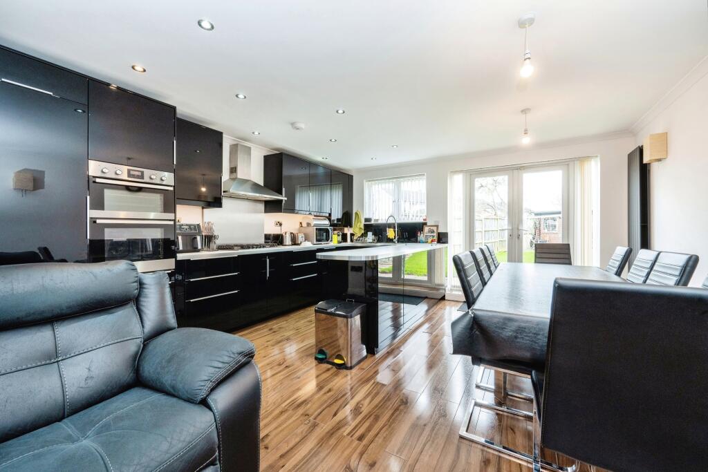
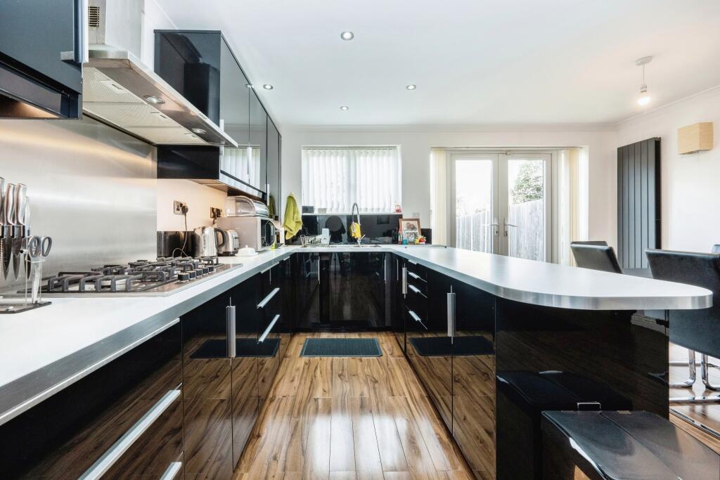
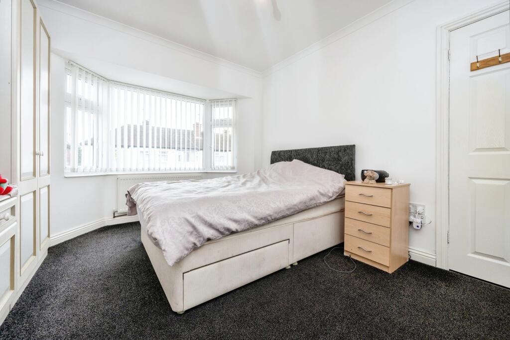
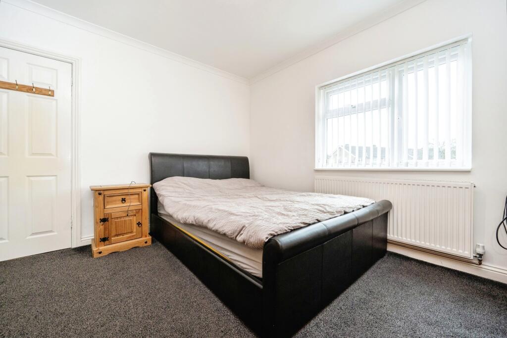
Description
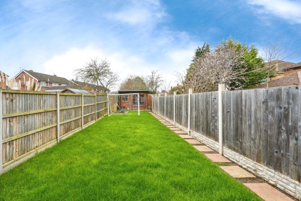
Externally, the property features a generous rear garden, complete with a versatile garden room at the rear. The location offers proximity to various amenities including shops, a main supermarket, and schools. With the convenience of a regular bus route to the town center and easy access to road links for commuting via the A6 and M1, this property presents an ideal blend of comfort and convenience for modern family living.
Listed by
Bedford
Countrywide UK Sales - Connells
Reference: 145243283
EPC Rating & Upgrade Cost
Fetching EPC data… Refresh this page in a moment.
Flood risk
Zone: 1
Risk: Low
Job (default Low)
Floorplans
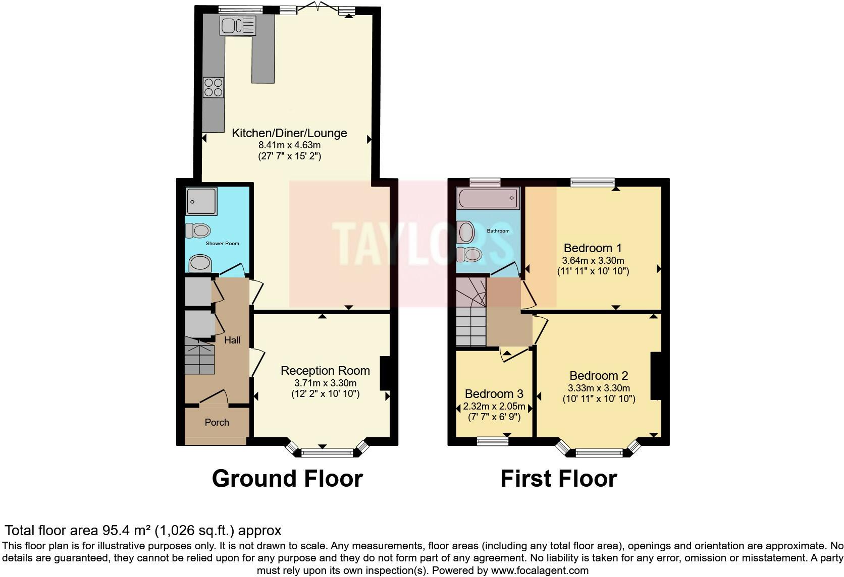
FLOOR-PLAN
EPC Graphs
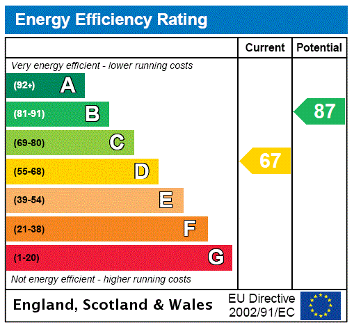
EPC Rating Graph
FENSA Certificates
This property has 1 FENSA certificate(s) on record, indicating window/door installations by FENSA-approved installers.
FENSA Certificate #10156627
Property Details
Street: 5 Broad Avenue
Town: BEDFORD
Postcode: MK42 9SN
Installation Details
Items: 5 windows
Certificate Issued: 17/03/2014
Work Completed: 21/02/2014
This certificate data was retrieved from FENSA's database
What is FENSA? FENSA (Fenestration Self-Assessment Scheme) is a government-authorised scheme that monitors building regulation compliance for replacement windows and doors. Certificates indicate that work was completed by FENSA-approved installers.
Price history
156% since 2013
| Event | Date | Price | % change |
|---|---|---|---|
| Sold | 18/02/2025 (1 year ago) | £300,000 | +156.4% |
| Sold | 18/10/2013 (12 years ago) | £117,000 | — |
Source: HM Land Registry Price Paid Data. Crown copyright.
Sold Comparables
Same street and nearby sales within 0.25 miles (last 5 years). Data from Land Registry Price Paid.
| Address | Price | Date | Type |
|---|---|---|---|
| Same street 9 BROAD AVENUE, BEDFORD, MK42 9SN | £260,000 | 14/11/2023 | Terraced |
| 141 MILE ROAD, BEDFORD, MK42 9UP | £295,000 | 15/09/2023 | Terraced |
| 22 HAREWOOD ROAD, BEDFORD, MK42 9TQ | £326,000 | 11/09/2023 | Terraced |
| Same street 11 BROAD AVENUE, BEDFORD, MK42 9SN | £257,500 | 12/05/2023 | Terraced |
| 15 ACORN WAY, BEDFORD, MK42 0QN | £299,999 | 20/06/2022 | Terraced |
| 106 MILE ROAD, BEDFORD, MK42 9TD | £295,000 | 08/04/2022 | Terraced |
| 58 MILE ROAD, BEDFORD, MK42 9TE | £332,000 | 17/02/2022 | Terraced |
| 46 BRACKLEY ROAD, BEDFORD, MK42 9SH | £165,000 | 11/08/2021 | Terraced |
Street average: £258,750 (2 sales)
Area average: £285,500 (6 sales)
Capital growth trend
Land Registry outcode average: last 12 months vs 5y and 10y ago (from sold prices).
House Price Index (HM Land Registry — official index, not sold-price averages): Bedford. Series: Terraced. As of March 2026.
Rental Range
Estimated market rent for Bedford. Low = conservative, Realistic = average, Optimistic = best case.
Based on Local Authority from postcode lookup → Bedford.
LHA (30th percentile) floor for Bedford: £997/mo (Apr 2025 – Mar 2026)
Location
Nearby
Nearest stations, universities and amenities (distance from property).
| Type | Name | Distance |
|---|---|---|
| Shop | Paul & Son | 0.1 miles |
| Shop | Costcutter | 0.1 miles |
| Bus stop | Unknown | 0.2 miles |
| Hospital | Bedford Hospital SDEC - Same Day Emergency Care | 0.7 miles |
| Train station | Bedford St Johns | 0.7 miles |
| Train station | Bedford | 1.4 miles |
| University | University of Bedfordshire Polhill Campus | 1.7 miles |
| Hospital | The Manor | 2.6 miles |
| University | Cranfield University | 8.0 miles |
Street-level crime
| Category | Count |
|---|---|
| Violence and sexual offences | 100 |
| Anti-social behaviour | 79 |
| Shoplifting | 64 |
| Criminal damage and arson | 27 |
| Public order | 24 |
| Other theft | 17 |
| Vehicle crime | 14 |
| Burglary | 11 |
| Drugs | 9 |
| Robbery | 7 |
| Bicycle theft | 6 |
| Other crime | 6 |
| Possession of weapons | 3 |
| Theft from the person | 3 |
| Total incidents | 370 |
Within 1 mile during Apr 2026. Source: data.police.uk (England & Wales).
Schools nearby
Nearest open schools with Ofsted ratings (England). Closed schools are not shown. Data from Get Information about Schools and Ofsted.
| Name | Type | Distance | Ofsted |
|---|---|---|---|
| Shackleton Primary School | Primary | 0.3 miles | Good — 10 Nov 2021 |
| Cherry Trees Nursery School | Nursery | 0.3 miles | Outstanding — 23 Jul 2019 |
| Bedford Academy | Secondary | 0.3 miles | Good — 16 May 2023 |
| King's Oak Primary School | Primary | 0.4 miles | Good — 2 Mar 2022 |
| Elstow School | Primary | 0.6 miles | Good — 13 Dec 2016 |
Rental Comparables
Residential lets from OpenRent and Rightmove for the area (same bedroom count). Use to validate rent estimates. Student lets are excluded.
| Title | Rent | Beds | Distance | As seen on |
|---|---|---|---|---|
| 3 Bed Bungalow, Broad Avenue, MK42 | £1,750/mo | 3 | 0.11 miles | OpenRent |
Average rent: £1,750/mo (1 listing)
Rent-driven metrics
Based on OpenRent comparables.
- This street — Gross yield for this street only (Land Registry sales + rental comparables, same postcode + street).
- Rent ratio — Monthly rent ÷ purchase price (1% rule). 1%+ = strong, 0.8–1% = okay, <0.8% = weak for cashflow.
- Max investor price — Rent ÷ 0.8%; the price at which rent would be 0.8% of price (Stoke-style target).
- Target investor price — Rent ÷ 1%; the price at which rent would be 1% of price (strong cashflow band).
- Gross yield — Annual rent as % of purchase price (no costs).
- Cost-to-rent — Price ÷ annual rent (from OpenRent comparables). Under 14× = strong, 14–16× = acceptable, 17×+ = compressed.
- Cashflow — Rent minus mortgage, 10% maintenance, £25/mo compliance. Assumes 75% LTV, 3.95% APR (5yr fixed), 25yr term.
- ROI — Annual profit ÷ cash in (deposit + 4% purchase costs).