The Bakers Arms
HIGH STREET, FARINGDON, UFFINGTON, OXFORDSHIRE SN7 7RP
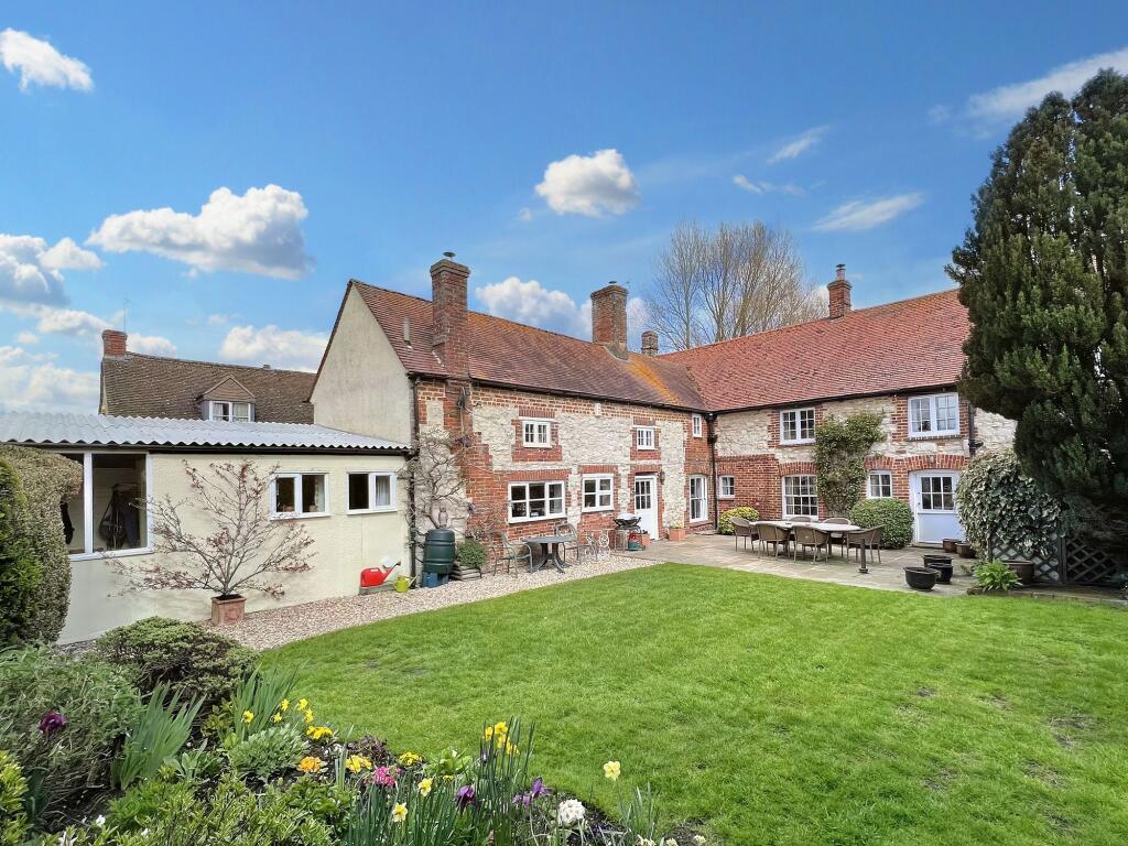


Photo 1 Photo 2 Photo 3 Photo 4 Photo 5 Photo 6 Photo 7 Photo 8 Photo 9 Photo 10 Photo 11 Photo 12 Photo 13 Photo 14 Photo 15 Photo 16 Photo 17 Photo 18 Photo 19 Photo 20 Photo 21 Photo 22 Photo 23
/ 23
Property details
Tenure
FREEHOLD
Council tax band
G
Last sold
£650,000 Sep 2007
Local average
£893,333 (-4.9%)
Deprivation
Decile 7 (20,703 of 33,755)
Street crime
3 incidents within 1 mile (Apr 2026)
Key features
- Stunning & Spacious Grade II Listed Period Property
- Bursting With Character Complete With Original Beams & Inglenook Fireplaces
- Five Bedrooms
- Three Bathrooms
- Five Reception Rooms
- Boot Room, Utility & Downstairs W/C
- Gated Driveway
- Detached Double Garage
- Landscaped And Private Rear Garden
- Popular Village Location
Additional details
- Electricity
- Mains supply
- Water
- Mains supply
- Sewerage
- Mains supply
- Heating
- Oil
- Parking
- Yes
- Garden
- Private garden
- Listed property
- No
- Restrictions
- No
- Required access
- No
- Rights of way
- No
- Flooded in last 5 years
- No
- Flood defences
- No
Description
This impressive property comprises; Entrance hall, downstairs w/c, utility room, boot room, pantry, workshop, kitchen/diner complete with AGA, dining room with inglenook fireplace and wood burner, L-shaped dual aspect sitting room with inglenook fireplace, family room, office with access to garden, landing, two family bathrooms, five spacious and light bedrooms, master with en-suite shower room along with built-in wardrobes.
To the rear of the property is a gated gravel driveway which provides plenty of off-street parking which leads up to the detached double garage. The rear garden has been landscaped and is mainly laid to lawn along with well stocked flower beds, borders and specimen trees. There is also a large storage shed as well as raised vegetable/fruit beds.
The property is freehold and is connected to mains electricity, water and drainage. There is oil fired central heating throughout. This property must be viewed to be fully appreciated.
Listed by
Faringdon
Preece and Co (UK) limited
Reference: 173629886
EPC ratings on this postcode
We don't have a matched EPC for this property yet. Below are efficiency scores and details for other addresses on this postcode.
| Address | Current | Potential | Floor area | Age band | Type |
|---|---|---|---|---|---|
| 2 New Cottages, High Street, Uffington, FARINGDON | 58 | 82 | 79 m² | England and Wales: 1967-1975 | Detached |
| Apple Tree Cottage, High Street, Uffington, FARINGDON | 40 | 73 | 96 m² | England and Wales: 1950-1966 | Detached |
| Apple Tree Cottage, High Street, Uffington, FARINGDON | 39 | 85 | 80 m² | England and Wales: 1950-1966 | Detached |
| Brook Cottage, High Street, Uffington, FARINGDON | 48 | 68 | 133 m² | England and Wales: before 1900 | Detached |
| Curtis Cottage, High Street, Uffington, FARINGDON | 65 | 97 | 113 m² | England and Wales: before 1900 | Detached |
| Janecroft, High Street, Uffington, FARINGDON | 46 | 76 | 131 m² | England and Wales: 1967-1975 | Detached |
| Long Thatch, High Street, Uffington, FARINGDON | 54 | 63 | 215 m² | England and Wales: before 1900 | Detached |
| Packers Forge, High Street, Uffington, FARINGDON | 37 | 72 | 169 m² | England and Wales: before 1900 | Detached |
| Pear Tree Cottage, High Street, Uffington, FARINGDON | 48 | 69 | 215 m² | England and Wales: before 1900 | Detached |
| Pear Tree Cottage, High Street, Uffington, FARINGDON | 46 | 73 | 229 m² | England and Wales: before 1900 | Detached |
| The Anchorage, High Street, Uffington, FARINGDON | 86 | 94 | 152 m² | — | Detached |
| The Coach House, High Street, Uffington, FARINGDON | 57 | 67 | 187 m² | England and Wales: 1983-1990 | Detached |
| The Coach House, High Street, Uffington, FARINGDON | 38 | 73 | 155 m² | England and Wales: 1967-1975 | Detached |
| The Sombornes, High Street, Uffington, FARINGDON | 53 | 71 | 184 m² | England and Wales: 1991-1995 | Detached |
| Vale Cottage, High Street, Uffington, FARINGDON | 25 | 53 | 167 m² | England and Wales: before 1900 | Detached |
Flood risk
Zone: 1
Risk: Low
Job (default Low)
Floorplans

All
Price history
110% since 1999
| Event | Date | Price | % change |
|---|---|---|---|
| Sold | 14/09/2007 (18 years ago) | £650,000 | +109.7% |
| Sold | 08/01/1999 (27 years ago) | £310,000 | — |
Source: HM Land Registry Price Paid Data. Crown copyright.
Sold Comparables
Same street and nearby sales within 0.25 miles (last 5 years). Data from Land Registry Price Paid.
| Address | Price | Date | Type |
|---|---|---|---|
| UFFINGTON STORES, UFFINGTON, FARINGDON, VALE OF WHITE HORSE, OXFORDSHIRE, SN7 7RA | £330,000 | 28/11/2025 | Other |
| Same street PEAR TREE COTTAGE HIGH STREET, UFFINGTON, FARINGDON, VALE OF WHITE HORSE, OXFORDSHIRE, SN7 7RP | £1,100,000 | 15/11/2023 | Detached |
Street average: £1,100,000 (1 sale)
Area average: £330,000 (1 sale)
Capital growth trend
Land Registry outcode average: last 12 months vs 5y and 10y ago (from sold prices).
House Price Index (HM Land Registry — official index, not sold-price averages): Vale of White Horse. Series: All dwelling types. As of March 2026.
Rental Range
Estimated market rent for Vale of White Horse. Low = conservative, Realistic = average, Optimistic = best case.
Based on Local Authority from postcode lookup → Vale of White Horse.
LHA (30th percentile) floor for Coventry: £997/mo (Apr 2025 – Mar 2026)
Location
Nearby
Nearest stations, universities and amenities (distance from property).
| Type | Name | Distance |
|---|---|---|
| Bus stop | Lady Walk | 0.2 miles |
| Bus stop | Shotover Corner | 0.2 miles |
| Shop | Absolutely Gorgeous | 3.4 miles |
| Shop | The Co-operative Food | 3.4 miles |
| Hospital | Wantage Community Hospital | 6.1 miles |
| University | University of Oxford | 7.9 miles |
| Train station | Richard Jefferies Halt | 8.8 miles |
| Train station | Lakeside | 8.8 miles |
| University | Royal Agricultural University (Cultural Heritage Institute) | 10.3 miles |
| Hospital | Marlborough House | 10.8 miles |
Street-level crime
| Category | Count |
|---|---|
| Violence and sexual offences | 2 |
| Criminal damage and arson | 1 |
| Total incidents | 3 |
Within 1 mile during Apr 2026. Source: data.police.uk (England & Wales).
Schools nearby
Nearest open schools with Ofsted ratings (England). Closed schools are not shown. Data from Get Information about Schools and Ofsted.
| Name | Type | Distance | Ofsted |
|---|---|---|---|
| Uffington Church of England Primary School | Primary | 0.2 miles | Good — 27 Sep 2022 |
| Longcot and Fernham Church of England Primary School | Primary | 2.3 miles | Requires improvement — 15 Jan 2023 |
| Shellingford Church of England (Voluntary Aided) School | Primary | 2.8 miles | Good — 24 May 2012 |
| Folly View Primary | Primary | 3.4 miles | Good — 15 Mar 2013 |
| Stanford In the Vale CofE Primary School | Primary | 3.5 miles | Good — 13 Mar 2013 |
Rental Comparables
Rental comparables are temporarily unavailable while listing-site fetches are paused. Try again later.
Rent-driven metrics
Based on Area rent estimate.
- Rent ratio — Monthly rent ÷ purchase price (1% rule). 1%+ = strong, 0.8–1% = okay, <0.8% = weak for cashflow.
- Max investor price — Rent ÷ 0.8%; the price at which rent would be 0.8% of price (Stoke-style target).
- Target investor price — Rent ÷ 1%; the price at which rent would be 1% of price (strong cashflow band).
- Gross yield — Annual rent as % of purchase price (no costs).
Enter House Number
Enter the house number to help us retrieve more accurate pricing history and property data.
Please log in to submit or correct the house number for this listing.
Log in to continue