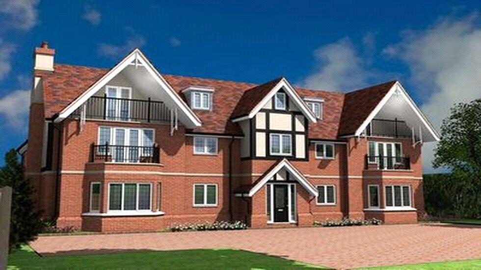
Apartment 2
LONGCROFT, 84, PACKHORSE ROAD, GERRARDS CROSS, GERRARDS CROSS, BUCKINGHAMSHIRE SL9 8JG
£1,550 pcm
Property details
Floor area
67 m²
Council tax band
E
Deprivation
Decile 10 (33,636 of 33,755)
Street crime
28 incidents within 1 mile (Apr 2026)
Key features
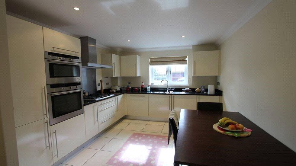
- Modern luxury apartment
- 15' Kitchen/diner
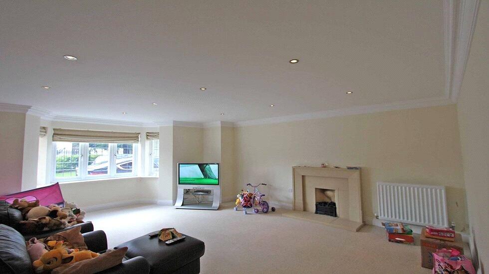
- 19' Living room
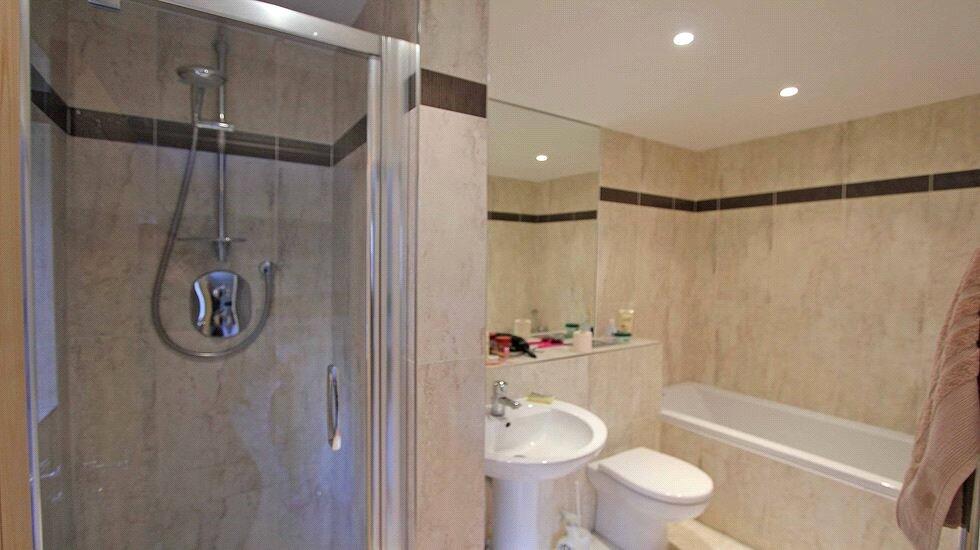
- Four piece en-suite bathroom
- Guest cloakroom
- UNFURNISHED
- One Allocated Parking Space
- Close to shops and station
Additional details
- Heating
- Gas central
- Parking
- Yes
Description
Listed by
Gerrards Cross Lettings
Leaders and Romans Group
Reference: 87880662
EPC ratings on this postcode
We don't have a matched EPC for this property yet. Below are efficiency scores and details for other addresses on this postcode.
| Address | Current | Potential | Floor area | Age band | Type |
|---|---|---|---|---|---|
| 88, Packhorse Road, GERRARDS CROSS | 63 | 73 | 250 m² | England and Wales: 1996-2002 | Detached |
| Apartment 2, Longcroft, 84 Packhorse Road, GERRARDS CROSS | 77 | 79 | 67 m² | England and Wales: 2007-2011 | Flat |
| Apartment 4, Longcroft, 84 Packhorse Road, GERRARDS CROSS | 81 | 81 | 71 m² | England and Wales: 2003-2006 | Flat |
| Apartment 6 Longcroft, 84, Packhorse Road, GERRARDS CROSS | 84 | 84 | 91 m² | England and Wales: 2007-2011 | Flat |
| APARTMENT, 7 LONGCROFT, 84 PACKHORSE ROAD, GERRARDS CROSS | 81 | 81 | 105 m² | England and Wales: 2007-2011 | Flat |
| APARTMENT, 8 LONGCROFT, 84 PACKHORSE ROAD, GERRARDS CROSS | 77 | 77 | 68 m² | England and Wales: 2003-2006 | Flat |
| Flat 1 The Lodge, 86, Packhorse Road, GERRARDS CROSS | 71 | 73 | 40 m² | England and Wales: 2003-2006 | Flat |
| FLAT 2, THE LODGE, 86 PACKHORSE ROAD, GERRARDS CROSS | 72 | 77 | 40 m² | England and Wales: 1991-1995 | Flat |
| Flat 3 The Lodge, 86, Packhorse Road, GERRARDS CROSS | 81 | 81 | 50 m² | England and Wales: 2003-2006 | Flat |
| Flat 4 The Lodge, 86, Packhorse Road, GERRARDS CROSS | 75 | 78 | 51 m² | England and Wales: 2003-2006 | Flat |
| Flat 4, The Lodge, 86 Packhorse Road, GERRARDS CROSS | 75 | 76 | 50 m² | England and Wales: 2003-2006 | Flat |
| Flat 5 The Lodge, 86, Packhorse Road, GERRARDS CROSS | 83 | 85 | 94 m² | England and Wales: 2003-2006 | Flat |
| Flat 5, The Lodge, 86 Packhorse Road, GERRARDS CROSS | 75 | 76 | 95 m² | England and Wales: 2003-2006 | Flat |
| Flat 8 The Lodge, 86, Packhorse Road, GERRARDS CROSS | 77 | 78 | 87 m² | England and Wales: 2003-2006 | Flat |
| Pinewood Lodge, 98 Packhorse Road, GERRARDS CROSS | 67 | 78 | 255 m² | England and Wales: 1950-1966 | Detached |
Flood risk
Zone: 1
Risk: Low
Job (default Low)
EPC Graphs
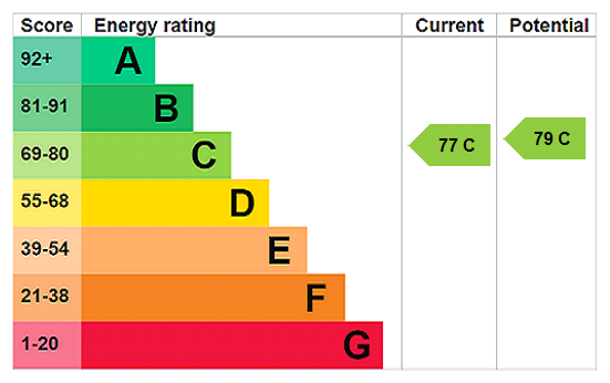
EPC Rating Graph
Rental Range
Estimated market rent for Buckinghamshire. Low = conservative, Realistic = average, Optimistic = best case.
Based on Local Authority from postcode lookup → Buckinghamshire.
LHA (30th percentile) floor for Bedford: £648/mo (Apr 2025 – Mar 2026)
Location
Address
Packhorse Road
Nearby
Nearest stations, universities and amenities (distance from property).
| Type | Name | Distance |
|---|---|---|
| Shop | Coco Nail Bar | 0.2 miles |
| Shop | Salon 77 | 0.2 miles |
| Train station | Gerrards Cross | 0.3 miles |
| Bus stop | Austenwood Common | 0.4 miles |
| Bus stop | The Bull Hotel | 0.6 miles |
| Train station | Denham Golf Club | 1.7 miles |
| University | Unknown | 5.1 miles |
| Hospital | Watford General Hospital | 7.5 miles |
| Hospital | Hounslow Medical Centre | 11.4 miles |
Street-level crime
| Category | Count |
|---|---|
| Violence and sexual offences | 7 |
| Shoplifting | 5 |
| Criminal damage and arson | 4 |
| Anti-social behaviour | 3 |
| Public order | 3 |
| Burglary | 2 |
| Vehicle crime | 2 |
| Other theft | 1 |
| Possession of weapons | 1 |
| Total incidents | 28 |
Within 1 mile during Apr 2026. Source: data.police.uk (England & Wales).
Schools nearby
Nearest open schools with Ofsted ratings (England). Closed schools are not shown. Data from Get Information about Schools and Ofsted.
| Name | Type | Distance | Ofsted |
|---|---|---|---|
| St Mary's School | Other | 0.1 miles | — (No rating) |
| Thorpe House School | Other | 0.3 miles | — (No rating) |
| Gayhurst School | Other | 0.6 miles | — (No rating) |
| Maltman's Green School | Other | 0.7 miles | — (No rating) |
| St Joseph's Catholic Primary School | Primary | 0.7 miles | Good — 15 Sep 2017 |
Rental Comparables
Residential lets from OpenRent and Rightmove for the area (same bedroom count). Use to validate rent estimates. Student lets are excluded.
| Title | Rent | Beds | Distance | As seen on |
|---|---|---|---|---|
| 1 Bed Flat, The Lodge, SL9 | £1,300/mo | 1 | 0.01 miles | OpenRent |
| Studio Flat, The Masons, SL9 | £1,095/mo | 1 | 0.24 miles | OpenRent |
| 1 Bed Flat, The Masons, SL9 | £1,295/mo | 1 | 0.24 miles | OpenRent |
| 1 Bed Flat, Oakridge Place, SL9 | £1,600/mo | 1 | 0.29 miles | OpenRent |
| 1 Bed Flat, Aston House, SL9 | £1,500/mo | 1 | 0.32 miles | OpenRent |
| 1 Bed Flat, Packhorse Road, SL9 | £1,200/mo | 1 | 0.37 miles | OpenRent |
| 1 Bed Flat, Woodlands, SL9 | £1,449/mo | 1 | 0.47 miles | OpenRent |
| 1 Bed Flat, Woodlands, SL9 | £1,549/mo | 1 | 0.47 miles | OpenRent |
| 1 Bed Maisonette, Woodlands, SL9 | £1,549/mo | 1 | 0.47 miles | OpenRent |
| 1 Bed Maisonette, Woodlands, SL9 | £1,549/mo | 1 | 0.47 miles | OpenRent |
| 1 Bed Semi-Detached House, Woodlands, SL9 | £1,649/mo | 1 | 0.47 miles | OpenRent |
Average rent: £1,430/mo (11 listings)
Enter House Number
Enter the house number to help us retrieve more accurate pricing history and property data.
Please log in to submit or correct the house number for this listing.
Log in to continue